In the previous episode, our dauntless adventurers had spent numerous days exploring the wilds of Chile’s Torres del Paine National Park, where they had run with the guanacos; risked being eaten by pumas; eluded the spell of a Selk’nam sorceress; were formally introduced to Patagonia’s hellacious wind; and had met a sweet Irish couple who could match their proclivity for hiking and whiskey-drinking. But they are only now halfway through their trip. More awaits, just across the border. Next stop: Argentina.
~~~~~~~~~~~~~~
BIG SKY COUNTRY
The morning that we departed Torres del Paine National Park was the sunniest we’d had all week. And after all the hiking sorties we had done, it felt good to have a “road trip” day of driving, listening to tunes on the stereo and sightseeing out the windows. We were eastbound, past herds of guanacos and the sparkling green waters of Sarmiento and Toro Lakes, and then up to the Argentine border at Don Guillermo Pass. Today was to be our “border crossing” day, and I was banking that it would go smoothly. It would be a first for me
(crossing into Mexico and Canada don’t count).
 |
| Hotel Las Torres |
 |
| Leaving Torres del Paine Nat'l Park. |
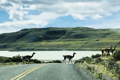 |
| Guanaco crossing. |
The Chilean customs house sits right on the pass, and we parked the car out front and wandered into the building, studying a multitude of signs in Spanish to ascertain the process for crossing an international border in the boondocks. After standing five minutes in the wrong line, we were civilly directed to the proper one—a longer line—and we started over. There was a procedural learning curve to all this, but I felt prepared when it came time to produce our rental car paperwork. These documents are paramount for a successful border crossing, or so I had read while looking into securing the car. I had come across internet posts by angry, international travelers who were turned around at the Chilean-Argentine border because they didn’t have the proper documents from the rental company
(which take up to thirty days to process!). When I passed the papers across to the agent behind the window, he meticulously checked our passports with the rental car docs to assure all of the info matched. And everything looked okay… until it wasn’t. He seemed to be searching for something and couldn’t find it.
“Necesito el registro,” the agent said to me.
Huh? For a moment I panicked. Was the paperwork screwed up?
“Registro de vehículo,” he tried again, pointing to the cars parked out front.
Vehicle registration! Si! I dashed out and fished it from the glove box. Problem solved.
In due course we were back in the car and driving across the border… only to stop at the Argentine customs house a mile down the road and do it all again. This time I had the car registration in the packet. The agent scrutinized everything; made some data entries into his computer; stamped our passports; handed them back to us and said: “Welcome to Argentina.”

Most of Patagonia is in Argentina, and most of it is rolling steppes of scrub and grass stretching to the horizon, not a tree in sight. Towns are small and few. This is Big Sky country, where you find an occasional cattle ranch or sheep farm, called estancias, tucked into the leeward side of a hill to shelter it from the pervasive wind. Glacier-fed rivers meander like turquoise veins across the land, bringing life. It is South America’s version of our Wild West, where adventurous souls once ventured to find fortune or escape the law. In 1860 an eccentric Frenchman, Orélie-Antoine de Tounens, proclaimed himself King of Patagonia with full support of the indigenous Mapuche tribes. Butch Cassidy and the Sundance Kid fled here in 1904 to evade U.S. marshals. They bought a 15,000-acre ranch and raised cattle for four years before the law caught up with them. The outlaws and Mapuche warriors are all gone today, but the wide open spaces remain unaltered.
Those wide open spaces made me a little anxious as we drove deeper into the steppes, for we had left that morning with only a partial tank of gas. There are no filling stations in Torres del Paine. Puerto Natales is the closest town to get gas, but it was in the opposite direction of where we were heading. So we had talked the hotel staff into selling us ten liters from their private supply which, hopefully, would get us to the next gas station down the road somewhere. The desk clerk had said it would be Esperanza, eighty miles past the border. It was going to be close: a good wager if I were a betting man.
 |
| Sheep on the move. |
As it turned out, we didn’t have to push our luck too far. We came across a gas station thirty minutes up Argentina’s Route 40, across the road from a small estancia called Tapi Aike, two buildings and a couple of pumps in the middle of
nowhere (my road map indicated a station here, but the hotel desk clerk had insisted it didn’t exist). The sign on the pump said no credit cards, cash only—and we didn’t have any Argentine pesos. But that wasn’t a problem: the station owner took U.S. dollars.
With a full tank of gas we continued north, crossing the Santa Cruz River and along the east shore of Lake Argentina, a glimmering sheet of topaz in the afternoon sun. We had been driving for two and half hours when we came around a bend and saw ragged peaks on the distant horizon. I estimated them to be around twenty miles away, but I was wrong. It was more like
SIXTY miles. Ever so slowly they grew in size, and the closer and larger they got, the more excited I became. Climbers know it well: the Fitz Roy Skyline. And after all of the photographs I’d seen of those peaks in climbing mags over the years… they were now right in front of me, filling the windshield.
.....................................
EL CHALTEN
The Tehuelches called it Chalten, which means “smoking mountain.” The near-perpetual “smoke”, however, is actually clouds, formed when moisture in the westerly winds condense over the Southern Patagonian Ice Field and crash into the mountain like a tsunami. Being the tallest peak in the range
(11,171 ft), it caught the eye of Argentine explorer Francisco Moreno during his 1877 survey expedition. He named it Fitz Roy, in honor of Captain Robert FitzRoy of the HMS
Beagle. Chilean and Argentine cartographers thus labeled the peak Fitz Roy in their mapping efforts of the next three decades. But the Tehuelches continued to call it Chalten.
For over a century both Chile and Argentina had claimed sovereignty to the territory around these mountains, and even today the dispute hasn’t been completely resolved
(on Google Maps, note the Chilean-Argentine border south of Cerro Fitz Roy is left blank for about forty miles). In 1985, to solidify their claim, the Argentine government established a small settlement just east of Fitz Roy on the Vueltas River. They built a police and fire station, a school, and housing for a dozen or so families. Then they gave the town a name: El Chalten. Today around 1,600 people live here during the tourist season
(Dec thru Apr) and more coming every year. The town is literally surrounded by Los Glaciares National Park, a cornucopia of mountains, glaciers, alpine lakes and rivers. I couldn’t wait to get at them.
 |
| El Chalten and the Fitz Roy Skyline |
 |
| El Chalten |
We rolled into El Chalten at the end of the day. Kevin had secured a two-bedroom cottage apartment behind a chocolate shop that would become our base of operations for the next few days. Our landlady, Anita, was a tall, striking woman who wore LaSportiva approach shoes and got us settled into our place. Her husband, Leo, ran the chocolate shop up front, his specialty being homemade alfajores. Their children were playing soccer with other kids in the back yard. I tried to get in on the game, but was woefully outmatched. Young whippersnappers.
Later we strolled down the main drag to find a place for dinner. The street was lined with small restaurants and cantinas, all of them bustling with patrons. Three young backpackers, shouldering heavy loads, marched past us on the sidewalk, followed by a middle-aged couple walking their dog
(more on the dogs later). There was a whole different vibe here than at Torres del Paine. You could feel the vivacity like an electric current. Big mountains beckoned at the edge of town—and a frontier town at that. There are two markets here, and a small bank with an ATM to get pesos—until the machine runs dry
(usually by late morning). There is one gas station; a couple of pharmacies; a police and fire station; a medical clinic... If you need more than that, you drive 130 miles to El Calafate. It’s the price you pay for living in an untamed paradise.
 |
| Our home at Anita's Place. |
 |
| Out for an evening stroll. |
Mi Viejo Nando was our choice for dinner, a few blocks down from where we were staying. Kevin ordered a good bottle of Argentine Malbec from the Mendoza region. I ordered up a steak… and was flabbergasted. Wow. It was probably one of the best—if not
THE best—steak I’d ever eaten
(at the least, tied with Doe’s Eat Place in Greenville, Mississippi). I’d heard the stories about beef from Argentina, and I’m here to tell you the stories are true. The cattle graze on pure pampas grass with no grain or hormones pumped into their diet, living under a big blue sky… It was the Wild West all over again. Like it should be.
.....................................
OBSCURED BY CLOUDS
At an elevation of 10,264 feet, Cerro Torre is only the eighth-highest peak in the Patagonian Andes. But from a mountaineer’s perspective, its story is steeped in melodrama and controversy like no other. The colossal spire soars four thousand feet above the glacier, sheathed in ice and battered by storms on a regular basis, and was called the “Impossible Mountain” for many years due to the long string of climbers who had failed to gain its summit. It’s big. It’s steep. The weather is usually awful. Alpinist/writer Greg Crouch once said that getting caught on this tower in a bad storm was akin to being mauled by a rabid dog.
So it came with much applause in 1959 when Italian alpinist, Cesare Maestri, claimed that he and his partner, Toni Egger, had climbed to the summit of Cerro Torre. Or had they? Only Maestri returned, reporting that Egger had fallen to his death on the descent, along with the camera and summit photos. In the ensuing years other teams made attempts at the summit, and all failed, leading some to suspect that maybe Maestri had never succeeded either. In 1970, Maestri returned to set the record straight, choosing a different line up the monster. The climb’s final headwall was as tall and sheer as an 80-story skyscraper, and for this he brought a secret weapon—a gasoline-powered air compressor. With this 200-pound beast, he was able to drill at a wholesale rate and install a line of bolts straight up the wall—only to retreat two hundred feet from the summit! So close. But close only counts when playing horseshoes or throwing hand grenades, so a substantiated first ascent would remain lost in the clouds. Furthermore, the use of a compressor to drill hundreds of bolt holes sparked a firestorm in alpinist circles, prompting Reinhold Messner’s manifesto
The Murder of the Impossible.
It wasn’t until 1974 that an undisputed first ascent was made by Italians Daniele Chiappa, Mario Conti, Casimiro Ferrari and Pino Negri via the Ragni Route up the west face. As for Maestri’s bolt-fest up the southeast side—infamously known as the
Compressor Route—it finally saw a successful summit bid by Americans Jim Bridwell and Steve Brewer in 1979. This route, with the rusty compressor still hanging from the upper wall, would become the most popular line up Cerro Torre. That is, until six years ago, when a Canadian-American duo chopped all the bolts on their descent from the summit, which prompted yet another firestorm over ethics, artistic expression and fascism. The route sees little traffic now. To date, only two or three parties have been able to climb it without the bolt ladders.
 |
| The infamous compressor. (photo by Lincoln Else) |
 |
| David Lama on first free ascent of the Compressor Route in 2012. (photo by Lincoln Else) |
One of my reasons for going to Patagonia was to see this iconic tower up close, and Kevin and I chose it for our first hiking day in El Chalten. It was 7½ miles up to Laguna Torre
(as close as you can get without an ice axe and crampons), and the trail started right at the edge of town and ascended without delay into the foothills. The morning was mostly cloudy with hints of sunshine to come—or at least that’s what we were hoping. After an hour of hiking, we reached the overlook where one can catch their first glimpse of Cerro Torre at the head of the Fitz Roy River valley. But there was nothing to see: the high peaks were all socked in. So we continued on, dropping down to the river and following it upstream.
In an old-growth beech forest we came upon three German climbers who were loping down the trail with full packs. They had just spent a week at the base of Cerro Torre, hunkered down in their tent to wait out the high winds, sleet and snow in near-whiteout conditions. The rock was sheathed in ice; food and fuel were running low. Finally they decided to bail. I tried to shine a little encouragement on their beleaguered state, saying that all they needed was a resupply run into town; a little rest; a hot shower. Then they could head back up when the weather improved and give it another shot. One of them smiled and shook his head: “No. We’re done.”
 |
| Fitz Roy Valley with Cerro Torre lost in the clouds. |
 |
| Kevin chats with a German climber. |
 |
| Beech forest along Fitz Roy River. |
When we reached Laguna Torre at noon, all the high peaks were still cloaked behind a curtain of mist and clouds. We settled into a comfortable nook in the rocks on the lake shore, eating our lunch in solitude, only a handful of hikers coming and going. Certainly the clouds would eventually burn off and reveal the spire. Right? After an hour the clouds began to lift, ever so slowly, exposing the glacier that skirted the base of the tower, and then the lower ramparts of stone and snowy ledges came into view... But that was as good as it got. After two hours of waiting, the upper two-thirds of the monolith were still hidden from us. And we couldn’t wait any longer. It was time to go.
As we trekked down along the rushing waters of the Fitz Roy River, I kept peeking over my shoulder to see if the tower had decided to reveal itself. It never did. At a stream crossing we met two Canadian climbers who were heading up, fresh and energized, nine-millimeter alpine ropes and crampons lashed neatly to the tops of their packs. They eyed the cloud buildup dubiously, yet retained an astute dose of optimism and can-do savvy. We wished them all the best. But as Kev and I had witnessed, the weather calls the shots on Cerro Torre.
 |
| At Laguna Torre, waiting for the clouds to lift. |
 |
| Heading back to El Chalten. |
.....................................
FINDING OUR GROOVE & THE LUCK OF THE IRISH
It rained all night after the Laguna Torre hike. In the morning it drizzled, a cold wind sweeping down the valley that would compel anyone to lose interest in going hiking. This made it a great day for souvenir hunting, and Denise had already cased out the shops, making my job easier. Chalten has one main drag—San Martin Avenue—so it didn’t take long for us to get the lay of the land. After shopping, it was time to grab lunch, so we stopped in at a bistro at the top of San Martin called
El Muro. It means “The Wall”, which refers to the two-story, overhanging climbing wall on the outside of the building. Inside, Argentine alt-rock filled the room and vintage ski and climbing paraphernalia adorned the walls. The bohemian flair was well suited for this town.
We were just finishing lunch when Kevin got the text message from Pete and Nicki: They had just arrived in town. Four days had passed since we last saw our Irish friends in Torres del Paine. They had since taken a bus into Argentina, first to El Calafate, and then to Chalten where they secured an apartment not far from where we were staying. The good chemistry we had felt with them in Chile had endured, and we picked up right where we left off when we got together again. Their quick wit and humor was second to none—what the Irish call “having the craic”. Pete had been a criminal defense lawyer back in Belfast, and Nicki had worked for the government
(Pete suspects she was an international spy, but she won’t cop to it because then she’d have to kill him). But then one day, about a year ago, both of them up and quit their jobs and moved to Peru, where they volunteered at a school in a poor neighborhood of Lima. Now they were on “summer vacation”, traveling through the hinterlands of South America.
 |
| The view from Mirador de Los Cóndores. |
We hit the town with Team Belfast that night. Our Arts & Culture Director, Denise, had made reservations at an artsy café/hostel that showcased live Argentine folk music, and we waded into a crowded room of mostly locals who had come to watch three talented musicians perform. There was no place left to sit, except for an empty couch and sofa chair directly in front of the stage—and on the seats were hand-written notes that said “RESERVADO PARA DENISE.” I don’t know how she pulled it off. We purchased some bottles of wine, kicked back, and enjoyed some superb music, like we were being entertained in our own living room.
The night was still young when the show ended
(translation: It’s nine o’clock and it’s broad daylight), so we sought out a restaurant called
Ruca Mahuida where pizza is their specialty. The place was rocking when we walked in, over half the tables shoved together to accommodate a large contingent of the Italian Alpine Club. Good cheer, wine, and ale flowed freely. One of the Italian alpinists, who told me he had cut his teeth on the limestone walls of the Dolomites and that Walter Bonatti was a god, waltzed across the room with the waitress, singing and twirling through the chaos and into the kitchen. It was one of those nights.
 |
| Front row seats at Kaulem's Hosteria & Gallery. |
In the morning, Kevin discovered that his wallet was missing. He and Denise had turned our cottage upside down searching for it. The car, too. Nothing. He then drove to the
Ruca Mahuida, knowing that he had it when he paid the dinner tab last night. Nope. Not there, either. Our landlady, Anita, suggested that he check the police station—it was a long shot, but what the heck. As he was driving there, Anita called the station and explained the circumstances, and she was still on the phone with the desk sergeant when Kevin walked in.
“Debes ser Kevin,” the officer said as he handed him his wallet.
Talk about luck. A small wad of pesos was missing, but everything else was there. Taking it as a good omen, we picked up Pete and Nicki in our trusty dusty Renault and rattled our way up the Vueltas River for some hiking and sightseeing. One of our jaunts was a scenic loop up to Laguna Azul, where Pete and Nicki made some delicious sandwiches and passed them around
(they had packed a complete deli!). We were almost back to the car when I realized that I’d lost my sunglasses. For the past mile of bounding down the trail, I had propped them on my head, the temples tucked under my fleece headband, but somehow they’d popped off. Right away I turned around and retraced our steps, scanning the grass and shrubs on both sides. I knew it would be like finding a needle in a haystack, but I had just bought them before the trip
(because I lost the last pair the same way). And guess what? I found them in a bush! That’s when I realized that maybe Pete and Nicki were bringing us good luck. They were our four leaf clover.
 |
| Only one at a time across the footbridges. |
 |
| Lake Azul. |
 |
| Lining up the next shot. |
 |
| Cerro Fitz Roy from Lake Azul. |
We invited them to our place that night for dinner. A pot luck
(no pun intended). We had leftovers from a pasta meal that Denise had cooked up two nights earlier, and Pete and Nicki brought half a pizza left over from last night’s meal at
Ruca Mahuida. Plus wine... and the last of Denise’s whiskey, the same bottle she had opened that first night in Punta Arenas. Outside, a wind-driven rain pattered against the side of the house as we laughed and bantered in the kitchen over a rollicking game of cards. We had found our groove in El Chalten.
.....................................
LAGOON OF THE THREE
Even with the bleak skies and spatters of rain during breakfast, we were committed to hiking up to Laguna de Los Tres. This was the premier hike of the area and we only had two days left to get it done. If we got hosed by foul weather today, we could always try again tomorrow—unless things got worse. It
IS Patagonia. Denise opted out, so it would be Kev, me, and Team Belfast going for it.
The main trailhead for Laguna de Los Tres starts right in town, and that’s the way most people do it. We, however, had a car. That allowed us to drive twenty minutes up the Vueltas River valley to the north end of Los Glaciares NP, and from there, take a less-traveled trail that would lead to the same objective. The hiking distance would be about the same
(16 miles round trip), but the harder-to-reach trailhead would equate to more solitude, at least until it joined up with the other trail for the final climb to the lake.
The hike began on the banks of the Blanco River, at the end of a dirt road that led to a quaint little inn called El Pilar In fact the trail started right in front of the inn’s dining room windows, which faced onto the river and high country. Hurrying past a couple inside who were eating breakfast, we were soon engulfed in a luxurious forest of old-growth lenga, a strong wind rustling through the big trees, heavy branches creaking with every gust. Once again, we got lucky with the weather as the damp, icy morning progressed into a fine day of partly sunny skies, and even the wind settled down. And as we had hoped, the Rio Blanco Trail was secluded, no traffic, and the view of the Piedras Blancas Glacier across the valley was utterly spectacular.
 |
| Start of the Rio Blanco Trail. |
 |
| Piedras Blancas Glacier. |
We stopped for lunch near Poincenot Camp, enjoying a tantalizing view of Cerro Fitz Roy poking above the ridge. We were getting close. Rested and re-energized, we crossed the Blanco River and trudged up a steep mountainside of switchbacks and sun-baked rock, well above timberline now, and when we crested that last barren ridge, the view took our breath away. The azure waters of Laguna de Los Tres glinted in the sun. And rearing up behind it was a fortress wall of jagged peaks, spires, and the imposing monolith of Cerro Fitz Roy itself, larger than life. Laguna de Los Tres—which means “Lagoon of the Three”—gets its name from the three highest peaks along the skyline: Fitz Roy, Poincenot, and Saint-Exupéry. I sat on a rock and marveled it. For a long time.
Two Frenchmen, Lionel Terray and Guido Magnone, were the first to climb Fitz Roy in 1952. The peak didn’t see another successful ascent for thirteen years
(by Carlos Comesaña and José Fonrouge of Argentina), and a third ascent until 1968 when Yosemite hardman, Yvon Chouinard, led a team to the summit. Chouinard came away so enchanted with these mountains that he would use the Fitz Roy Skyline for the logo of his new company, Patagonia. Today, the Fitz Roy cordillera is the epicenter for serious alpine pursuits in the Patagonian Andes. And even if you’re not a climber, it’s hard not to sit there at Laguna de Los Tres and not feel the magic around you.
 |
| Poincenot Camp. |
 |
| Almost there... (my cover-photo to Senior Outside Magazine) |
 |
| Laguna de Los Tres. |
Nicki lounged on a flat rock above the lake, soaking up the sun’s rays, while we gents scrambled along the shore to an incredible overlook of Laguna Secia far below. The scenery was simply mind-blowing in any direction you ventured to look. We spent over an hour absorbing it with body, mind, and spirit. Nobody wanted to leave. But alas, we shouldered our packs and started down to the real world. Or maybe I’ve got that backwards?
 |
| Cerro Fitz Roy on the right; Cerro Poincenot on the left. |
For those wanting to get a better feel for the gravity and caliber of climbing in the Fitz Roy range: In 2014, two Americans, Tommy Caldwell and Alex Honnold, completed a stunning traverse of the entire Fitz Roy Skyline in one push, becoming the first to do it. You can watch a short but awesome trailer to the film that captured it HERE. Climbers like Tommy and Alex are among the best of the best. Just last week (June 6, 2018)
, they broke the speed record for climbing El Capitan in Yosemite Valley in one hour and fifty-eight minutes. No, that’s not a typo. That’s three thousand feet of vertical stone in… Under. Two. Hours.
.....................................
Navigation to...
PART ONE PART TWO PART FOUR


Marvelous narrative Master Barry - you really captured the essence of the place my friend... and a magical place it is!
ReplyDeleteLike the so-called trips to the moon, I'm certain this was all faked using Photoshop because, obviously, nothing could be that beautiful and spectacular.
ReplyDeleteYou got a point there, Robbie. The scenery was surreal. But no photoshopping. :-)
Delete