“When are you going to come visit me?” my cousin, Kathē, asked me. Again. It wasn’t the first time she had extended the invitation to visit her in the hinterlands of the Idaho panhandle, where she migrated fourteen years ago from Southern California. I always knew that I had an open invitation. Now it was October. Terry was back at work. So, what the heck… Let’s do this. Idaho, here I come! I packed the van, loaded up the mountain bike and grabbed a dog. I also called my long-time amigo, Sun Valley Rick, and warned him that I was coming his way. A little mountain exploring in the Gem State was on the agenda. More or less, hike and bike as much as my knee could handle.
- - - - - - - -
Clustertruck to St. George
It was ten o’clock on a Monday morning when I backed out of my driveway. The sun was bright. I was stoked. Toby was stoked. We would be in St. George in plenty of time for a sunset ride in Snow Canyon. Woohoo!
In spite of my bon voyage swagger, as soon as I turned the corner at the end of the block, I noticed that my turn signals were not working. Hmm. They had worked just fine yesterday when I filled up with gas and propane. Returning to the house, I pulled into the driveway and went spelunking under the dashboard to locate a loose connection or blown fuse. Everything looked fine. Now what?
Our mechanic’s garage is just three miles down the road, so I dashed over and asked Vinnie if he had time to take a look. He did. Electrical problems are either an easy fix… or a nightmare. I got the easy fix.
“A bad relay,” Vinnie said. They could have one delivered that afternoon. How much? He just waved me away. “Forget about it.”
Vinnie’s the Man.
It was two o’clock when I finally left town, driving up I-15 to Cajon Pass and out across the Mojave Desert. The turn signals worked like a charm. I was rolling into Vegas, baby, as the sun was setting, and that is when the traffic slowed to a crawl. Freeway night construction had just begun, and we all creeped along in a single lane, bumper-to-bumper, for what seemed like forever. But I was patient. I was chill. I engaged Toby in stimulating conversation (application of Mandelbrot fractal sets to Chaos Theory) until I broke free of the mayhem and was handed a wide-open highway to Utah. It would be smooth sailing to St. George now. Right?
Wrong.
An hour out of Las Vegas, the cars ahead of me hit the brakes and came to a dead stop. And there we sat. And sat. Trapped in the middle of nowhere with no exit ramps. I had a half-bar of cell service, enough to text Terry and ask if she could investigate the holdup. Her reply: “Northbound I-15 closed due to accident. Expect delays.” An understatement if I ever heard one.
That was at eight-thirty. By nine-thirty, motorists were dousing their headlights and shutting off engines—me included. Three college-age girls in the Toyota Camry ahead of me got out and rummaged for pillows and extra clothes in the trunk, and then jumped back in the car. The trucker in the eighteen-wheeler next to me was watching a movie—Mad Max, I think. Up and down the freeway, people were settling in for the night. I climbed in the back, got comfortable, and read my Kindle until I nodded off.
The shrill squawk of a siren and flashing blue lights woke me with a start sometime later. A state trooper was driving slowly down the shoulder, announcing via loudspeaker that it’s illegal to turn off your engine and headlights in a freeway lane.
Really?
It was one o’clock in the morning when the long procession of cars and trucks ahead of me began to move. Progress was slow at first. But, in due course, I was back to full speed ahead, into the night—and I never did see any signs of the accident that shut the freeway down for over four hours. The “Welcome to St. George” sign was a sight for sore eyes when it flashed by in the headlights. By the time my head hit the pillow, it was two-thirty in the morning. No, wait—it was actually three-thirty, because I’d crossed into the Mountain time zone. In any case, it was a lonnnng Day One of the trip.

- - - - - - - -
Up in Smoke
There are one thousand road miles between St. George and my cousin’s place near Sandpoint, Idaho. I was giving myself four days to cover the distance, with the notion that I would have time to tick off a trail ride each day as well. After a short, sweltering ride in Snow Canyon outside St. George, I drove up to Salt Lake City and found the entire basin choking in smoke. The majestic Wasatch Mountains at the edge of the city were lost in a smoggy haze. Was there a wildfire somewhere? Yep. BIG wildfires—500 miles away, in Oregon and Northern California. All the smoke was drifting east. Crossing into Idaho, the air quality wasn’t much better in Pocatello and Idaho Falls. I was almost in Montana before the ruddy skies began to show signs of turning blue again. Clearly, a good rainstorm was needed to wash away the haze—but it was not in the cards. Nevertheless, western Montana was inspiring. Big Sky Country, indeed. On the afternoon of Day 5 of the trip, I was into the Idaho panhandle, skirting the shores of Lake Pend Oreille, and arrived at my cousin’s house in time for happy hour. How’s that for timing?

Stoddard Creek Campground in Idaho, twelve miles from the Montana border. We spent the night of Day 3 here. The FS campground was officially closed for the season (restrooms locked; water shut off), but one could boondock. We had an entire campground loop to ourselves.
Ah, good Irish whiskey after a ride up Stoddard Creek, where Toby flushed a big-ass buck out of the trailside bramble (not that savvy with the Boone & Crocket Scale, but I’ll call it an 8-pointer). It bounded into the woods with der Pudelhund charging after it—and that’s when it hit me…. It’s hunting season. He returned several minutes later, empty-handed, and no worse for wear. He can run all day.
Late-afternoon hike along the Clark’s Fork River – Beavertail Hill State Park, Montana.
Clark’s Fork River. There was a fetching single-track along here.
Breaking camp at Beavertail Hill State Park, where most of the sites were vacant. Our next stop would be Sandpoint, Idaho. But first… One more ride along the Clark’s Fork.
The Clark’s Fork River near Thompson Falls. The Idaho panhandle is only an hour away.
- - - - - - - -
Welcome to Sandpoint
Sandpoint clings to the north shore of Lake Pend Oreille, not far from the Canadian border, and when my cousin, Kathē, moved up here fourteen years ago, I had to wonder: How was this sun-kissed, Southern California girl going to handle the winters up here? Very well, it turns out. She embraced them and made this lakeside paradise her new home. I stayed with her and her husband, Tom, for three days. It was good catching up, sequestered in the woods. Great meals. And rain. Yes, the fall weather had finally caught up with me, washing the last smudges of smoke from the sky.

Kathē & Tom’s place in the forest. They live in Sagle, a rural community near Sandpoint.
My cousin and Tom, getting dinner started. My job: Keep the wine flowing (a very important job, I might add).
A master chef.
Toby and Hamilton became fast friends. Being a city dog, der Pudelhund was intrigued with waking up in the morning to deer and wild turkeys in the front yard.
Old barn in Sagle.
- - - - - - - -
The Silver Valley
“You gotta check out Wallace,” my pal, Kevin, had recommended. He’s my go-to guy for hiking and biking in the Pacific Northwest. And I had already planned on passing through Wallace on my way back south, so why not?
It didn’t take much research to realize that I’d struck gold with Wallace. Or should I say “silver,” because the town sits right at the center of Idaho’s Silver Valley, the largest silver mining area in the nation at one time. But that’s not all. Just a few miles up a side canyon from Wallace is the old mining town of Gem, where my maternal grandmother had lived for a while when she was a child. She used to tell me stories of her life in a mining town—I just didn’t know where it was exactly, because she said it no longer existed. It was a ghost town. But lo and behold, I found it! (Thanks, Kev!)
Wallace, Idaho: a charming little town of around 900 people. Hard not to like. Founded in 1884, it became the hub of the mining and timber commerce for the area, with a population four times greater than it is today. Most of the town was destroyed in 1910 by a massive forest fire known as the Big Burn. The lucrative profits from the silver mines were used to rebuild it.
In 2004, the mayor of Wallace proclaimed that the town was the center of the Universe, and a manhole cover in the intersection of Sixth and Magnuson—the hatch clearly identifying itself as “The Center of the Universe”—marks the precise location. This prompted British comedian/writer, Danny Wallace, to visit Wallace, Idaho, and write a book: “Danny Wallace and the Centre of the Universe.” Or as the great Tommy Chong would say: “Far out, man.”
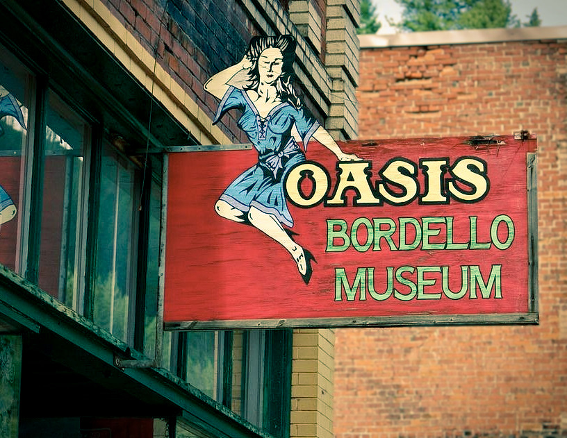
In its heyday, numerous brothels operated in Wallace, employing up to sixty young ladies to accommodate the demand (men outnumbered women 200 to 1). The Oasis was one of the last to close its doors in the 1950s. Now it’s a bordello museum—which, due to COVID, was closed.
Fall colors in the neighborhood.
Hiking the Pulaski Tunnel Trail, which starts on the outskirts of Wallace and ascends into the solitude of the West Fork of Placer Creek. Ed Pulaski, to which the trail is named, was a forester and local hero who led 40 of his firefighting crew to safety during the 1910 wildfire that destroyed Wallace. The trail leads back to an old mine tunnel where Pulaski—who knew these mountains like the back of his hand—led his crew to escape the inferno. We didn't quite make it to the tunnel: rain turned us around. (For a hair-raising account of the fire, plus a good narrative on the formative years of the U.S. Forest Service, I recommend reading The Big Burn.) West Fork of Placer Creek
Deep in the woods. The Big Burn turned the mountainsides here to barren ash 110 years ago.
Four miles out of Wallace, up Canyon Creek Road, is the mining hamlet of Gem. My grandmother lived here in 1923-25 when her father got a job in one of the mines. The money was good, but the work was dangerous.
A handful of people still live in Gem. The narrow canyon only has room for a row of houses on either side of the street. In fact, back in the day, the street also served as the rail line, because there was no other place to put it. Grandma, who completed the 6th and 7th grade here, told me that ore trains would run right through the middle of town. Boy, she wasn’t kidding.
Gem, circa 1900.
Misty rain in the mountains.
Three miles further up the canyon from Gem is the ghost town of Burke. It, too, was a thriving boomtown back in the day. It is estimated that, collectively, 5½ billion dollars of silver was extracted from the mines between here and Gem. The ruins in the background belong to the Star Mine, which operated from 1896 to 1981. It was the last to shut down.
The Star Mine has a vertical shaft that goes down 8,100 feet, making it the deepest mineshaft in North America.
The Star Mine’s administration offices.
Burke, circa 1910. Fun fact: Actress/pin-up model, Lana Turner, was born here in 1921.
Ruins on Shifters’ Hill. It was called Shifters’ Hill, which overlooks the old Burke townsite, because the company-owned homes along this slope housed the mining shift bosses.
And so concluded Day 8 of my trip, snapping photos of ramshackle homes on Shifters’ Hill in the rain. I returned to the van; drove back down to Wallace and jumped on I-90, heading east for Montana. The good news: the rain had stopped. The bad news: it was getting dark and I couldn’t find a place to camp for the night. I passed three campgrounds, and all three were closed for the season. Locked up. Cell reception was spotty. The Campendium app on my phone proved useless for finding something. Every time I would find a decent spot in the woods, it would be posted “No Trespassing” and “No Camping” (with bullet holes in the signs). It was getting late. I was hungry. Toby needed a drink. Now what?