To say it has been a weird year is an understatement. (Who would’ve thought toilet paper would become the most coveted prize in the universe?) Like most of you—if not all of you—we sheltered in our command bunker and watched March turn into April... May… June… Travel plans were scuttled. Zoom happy hours became vouge. Wine consumption skyrocketed. My hair got longer and longer.
When the closure protocols began to ease up, there was a cautious sense of relief. Could we travel safely? Sure. Just stay away from other people. Terry suggested that we head for the hills and go camping. Sounded good to me. How about a drive up the coast of northern California and southern Oregon? Perfect.
We threw the trip together just days before departure—not an easy task when many of the campgrounds were still closed due to COVID-19. It felt like we were planning the Zombie Apocalypse Road Trip: food; water; wine; TP; hand sanitizer; masks; disposable gloves; ninja poodles for protection; more TP; more wine. We were ready for anything—well, almost anything. Our van lacks a bathroom, and many of the campgrounds that were open would not promise that their restrooms and showers would be open. In fact, one campground required that your RV have a bathroom, otherwise they wouldn’t take you. So, as a hedge, we rented a Sprinter camper van. It was only four feet longer than our vintage rig, but had a small toilet/shower enclosure. NOW we were ready for anything.
Getting Started (More wine, please)
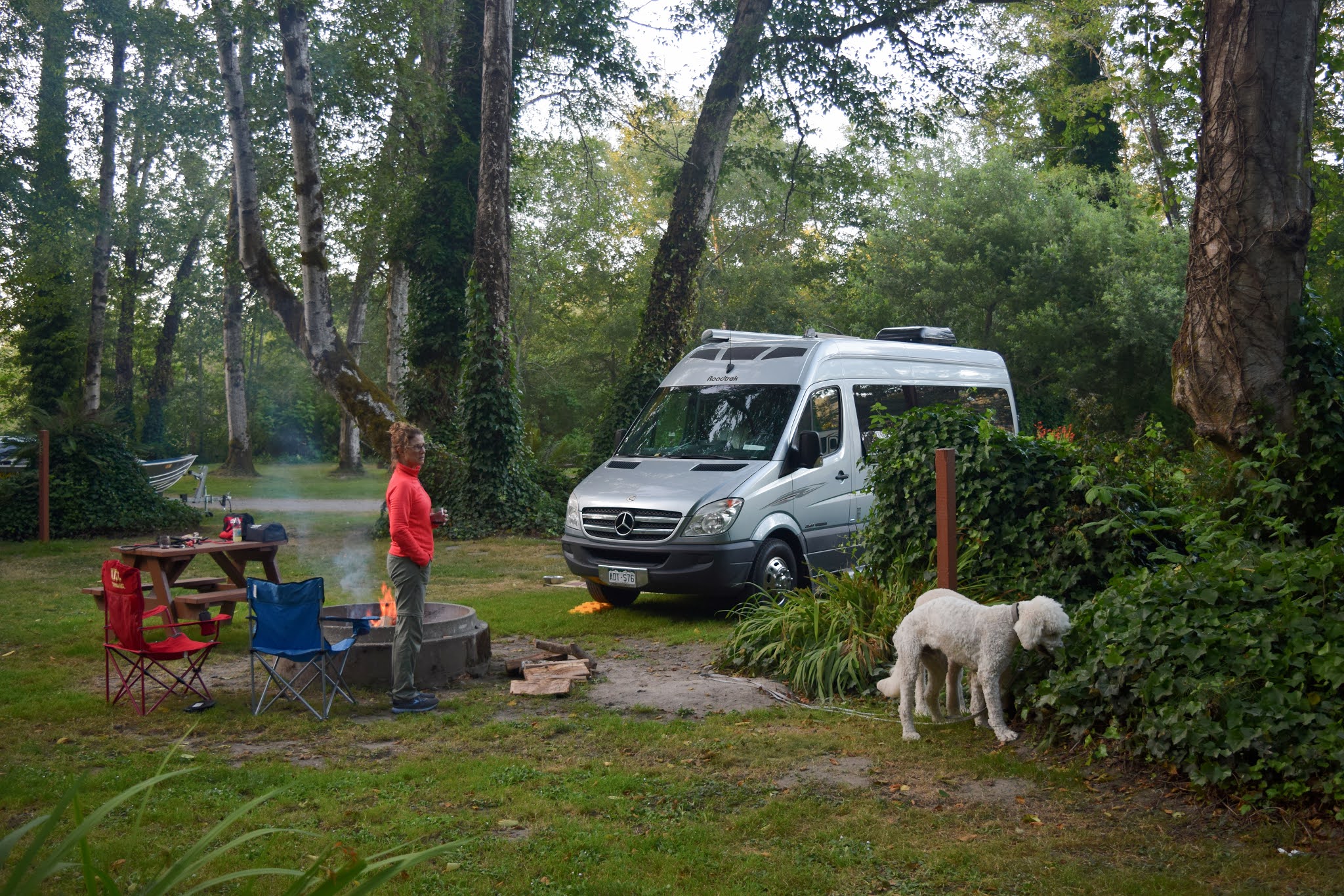
Our first camping night was in the Standish-Hickey Redwood Grove on the Eel River. It was a State Park campground, and we had booked one of the last sites before we left home. Lucky us. When we checked in at the gate, the ranger handed us the COVID-19 regulations, which we were required to sign to use the campground, that stipulated: 1) No more than eight people allowed in a campsite, and they must all be from the same household; 2) You are not allowed to visit other campsites; 3) Social-distancing protocols and masks are required when you leave your campsite, i.e. going to the restroom, fetching water, or hanging out at the river; 4) If you don’t follow the rules, the Park Service reserves the right to kick you out.
It sounded reasonable under the circumstances. Yet, only about half the people followed the guidelines to a tee (we were among the few who wore masks in the restroom). The most flagrant offenders were around the corner from us, where thirty or more people had gathered in two adjacent campsites, the adults crowding around the bonfire while their kids darted from campsite to campsite—and none of them were wearing masks. When we walked up to the entrance station office to complain, the young park ranger just froze, like a deer (wearing a mask) caught in the headlights. He finally responded with a feeble shrug of resignation, like: “What do you want me to do about it?”
We were not exactly off to a great start here. Returning to the van, we sheltered in place. And drank more wine. You can’t go wrong with wine during a pandemic.
Campsite at Standish-Hickey Redwood Grove

Driving through the stately groves of Humboldt Redwoods State Park. Humboldt County was the epicenter of the Timber Wars of the 1990s. Not far from here is the ancient redwood tree that Julia “Butterfly” Hill climbed to protest clearcutting of old-growth forests. She refused to come down, living on a 6’x 6’ platform at the top of the tree for 738 days to save the grove. The power of one. ~~~~~~~
I have explored the entire California coast over the years, from Mexico to the Oregon border, except for the Lost Coast. Somehow this stretch always got overlooked. It is remote and rugged, with few roads—all narrow and twisty—and even fewer people. It is a land of giant redwoods; hidden beaches; bucolic valleys… and pot farms. Loads of pot farms. We drove past a few of them, the plants now cultivated in greenhouses. (Fun Fact: 20% of Humboldt County’s population is involved in cultivating marihuana.)
An old, single-lane bridge spans across the Mattole River into the Land of the Lost Coast.
Exploring along the Mattole River. In case anyone is wondering, we have two dogs now. Meet the new guy, Wolfgang—aka Wolfie, or Dennis the Menace, or Dogzilla. He’s a poodle/golden retriever hybrid that we rescued; brought him home right when the zombie apocalypse hit.
Toby and Wolfgang in their element.
We spent the night at a county campground on the Mattole River, which had literally just re-opened two days before our arrival. We nabbed the last site. There were grassy open spaces between campers here—a far cry better than the crowded petri dish at the Standish-Hickey campground. The ranger apologized for the showers being closed. Not a problem: we have one in the van.
The Lost Coast has about eighty miles of shoreline, but only this six-mile stretch has a road running along the beach.
Stunning vistas around every turn.
The Lost Coast is the largest undeveloped coastline remaining in the nation outside of Alaska. The ranch house at the foot of the hill is the only residence for miles. (Check out the 360 view!)
~~~~~~~
This charming little town, founded in 1852, sits near the coast at the mouth of the Eel River, shrouded in fog most mornings. It’s the northern gateway to the Lost Coast and renowned for its restored Victorian homes and commercial buildings. Ferndale hosts the Humboldt County Fair—we camped on the fairgrounds—and is also the home of the
Kinetic Sculpture Grand Championship, a zany, artsy, human-powered race you gotta see to believe. (No race this year due to the pandemic). We spent a day strolling around town, checking out the neighborhoods.
Main Street, Ferndale.
Downtown was relatively quiet. Many of the restaurants were closed, and some of the shops as well. The pandemic has been economically brutal to these small towns who rely on summer tourists.
The elegant Gingerbread Mansion is now a B&B inn. It was built in 1895 by Ferndale physician, Dr. Hogan Ring.
Yet another beautiful restoration.
~~~~~~~
We camped four nights at the mouth of the Klamath River, a stone’s throw from the Yurok Nation. The tribe’s ancestral lands stretch forty-four miles up the Klamath to the confluence of the Trinity River: mountainous terrain where roads are few and far between. Steeped in ageless folklore, the river is part of the Pacific Northwest’s Salmon Coast. And to the Yuroks, as it always has been, salmon is everything.
We stayed at a private campground called Kamp Klamath, where the tent-camping area was only one-quarter full. Nice and quiet. It served quite well as a base camp for day excursions. A grand view of the mouth of the Klamath River. The cemetery in the foreground belongs to the Williams family, a Yurok clan who lived along these bluffs in the early to mid-1900s. They operated a fish camp on the beach below.
The weathered remnants of the Yurok fish camp below the Williams’ cemetery. The structure in the foreground is a sweat lodge. In the background at right is the ceremonial room.
Hiking out to where the river meets the sea. A coexisting tumult of wind, sun, and fog.
In the distance are fishermen at the ocean breakers. It was an ebb tide, and the river was deep and swift here. We kept the dogs out of the water.

We drove into the hamlet of Klamath one afternoon to find a laundromat (it was closed), and that’s when Terry spotted this fine-looking canoe parked on a back street. It had been carved from the trunk of a redwood tree, and while we were ogling it, the owner, Dave Severns, drove up and started hitching the trailer to his truck. Terry struck up a conversation, and Dave explained that he had learned how to make a dugout canoe from tribal elders. In that respect, it is an almost-lost art—sort of like real Navajo rugs—and he is determined to keep the knowledge from being lost. How long did it take to make this canoe? Two to three months, he said, using modern tools. But ages ago, with only stone and elk antlers for tools, it would take a master canoe-builder two years to complete one of this size. Dave had big plans of giving canoe tours up the Klamath this summer. Then the pandemic broke out.

This is all that remains of the old arch highway bridge that spanned the Klamath River. It was completely wiped out in the Christmas Flood of 1964 (as well as the village of Klamath), effectively cutting off Crescent City from the rest of the state. A bigger and better bridge was then built a mile upstream.
~~~~~~~
This was the main reason we came up here: Sequoia sempervirens, the tallest living organism on the planet. Half of the remaining old-growth redwood groves hug the coast between Crescent City and Eureka, protected in the contiguous reserves of Redwoods National Park, and California’s Jedediah Smith, Del Norte, and Prairie Creek State Parks. Over three hundred feet tall and a thousand years old... Big trees resonate with us.
The mystical forest.
Coastal redwoods gain most of their height during their first century of life. The tallest tree—discovered in 2006—is named Hyperion and stands 380 feet tall. It is over 600 years old and still growing at around 1½ inches per year. How do you measure the height of a redwood tree, you ask? Simply climb to the top and drop a tape measure to the base. I’m not kidding. Oh, and there is no trail to Hyperion, so you gotta find it on your own.
The old Cal-Barrel Road is now closed to vehicles and—even more importantly—dog-friendly. It meanders two miles up into old-growth groves with a few side trails to explore. Park rangers will frown—I mean a BIG frown (or a ticket)—if you take Fido on most of the other trails. So, remember… Don’t feed the rangers.
Here’s a riddle for you: Why did the elk cross the road?
At the coast of Prairie Creek State Park: windswept dunes and miles of empty beaches.
~~~~~~~
This bustling harbor town serves as the headquarters to the Redwoods National and State Parks. Trapper/trailblazer, Jedediah Smith, was the first European-American to visit and document the Tolowa fishing villages along the crescent-shaped cove. But things have changed a lot since 1828. We stopped here to re-supply at Safeway and seek out a laundromat. We also had dinner at a harborside restaurant called Crescent Seafood (our only dining out of the trip), where your meal is delivered fresh from the boat to the kitchen. Delicious.
The rugged coast between Klamath and Crescent City.
Fishing and crabbing are big in Crescent City. This is the new marina. The old one was destroyed in 2011 by a tsunami caused by the 9.0 earthquake in Sendai, Japan.
Terry wanted to charter a three-hour tour on this boat. I nixed it—the owners looked too much like the Skipper and Gilligan.
~~~~~~~
Oregon Beaches (A small sampling)
Other than day-sorties to the coast from Portland, we’ve never spent any time exploring the beaches of Oregon. Big mistake. We drove fifty miles north along the coast from the California border, and our takeaway is…. Astounding. Mind-blowing. It was one stunning beach after another and... NO PEOPLE! (Okay, there were few, but they hardly count.) We loved it. The dogs loved it. Three days were not enough. When are we going back?
Our camp was just outside Gold Beach. It was a small, private campground, mostly empty. They were only accepting parties who called ahead and had a bathroom in their RV. (Restrooms and showers were closed.)
Wolfie officially learned to swim in the Rouge River. Turns out, he’s quite the water dog.
Gold Beach
Ariya's Beach
Nesika Beach
~~~~~~~
Last Night in the Trinity Alps
Nobody was happy (especially the dogs) when our escape-the-pandemic road trip was nearing the end. Back in Northern California, we drove east through the mountains on the Trinity Highway, winding along the emerald ribbon of the Trinity River, where, in the fall, steelhead trout and salmon lurk for the catching. And then there’s Sasquatch. There are more Bigfoot sightings around here than any other part of the West. Camping on the Trinity would be our last night under the stars.
Nope. We didn’t see any of these dudes.
The Trinity River
Our last campsite.
An early-morning romp before the long drive home...