
Alas, after many months of planning, the Big Event of the Year was upon us. Terry’s son, Doug, would be marrying Brianna on May 7th up at Lake Tahoe, and it was like the final countdown to a mission to Mars. Nothing was overlooked. Everything was triple-checked. Terry would be flying up while I’d be taking the car. I had a half-dozen bottles of wine in the trunk, along with two cases of beer and a few gallons of Margaritas for the wedding rehearsal dinner that Ter was hosting—oh, and I was also transporting the exquisite dress that the groom’s mother would be wearing to the wedding. That’s why I needed to drive up: there was a load of freight to be delivered (just call me Mr. FedEx). We had it all synchronized. I would leave town before Terry so I could pick her up at the Reno airport precisely when she landed. Like I said, it was Mission to Mars (or if I screwed it up, Marooned on Mars).
While Ter was making the wedding an “extended weekend” event, I was stretching it into an eleven-day road trip—sort of a Tour de California—with intentions of bringing my road bike along. This idea had been hatched over the winter when I made plans with my long-time pal, Kevin, to come up to Sonoma County and ride King Ridge. Kev had raved about it. Everything I read on it was astounding: an ultra-scenic 50-mile loop, almost all of it on twisty, country lanes with steep grades to climb and race down. Count me in!
And so it was set. With the car loaded with booze, wedding apparel and a bike, I lighted out for Reno twenty-seven hours before Terry would arrive there by plane. The countdown had commenced.
~~~~~~~~~~~~
MAY 4th –
I roll into Adelanto at 9:00 AM, stopping at a Starbuck’s to secure more caffeine. If all goes to plan, I’ll be across the Mojave Desert and into the Owens Valley before noon. The goal today is to stop in Big Pine for a half-day spin up to Westgard Pass—Ride #1 of the trip—and then drive on to Lee Vining for the night where I’ve booked a room at Murphy’s Inn. It’s clear and sunny right now. But according to the weather forecast, that might soon change.
 |
| The old Silver Dollar Saloon in Red Mountain is boarded up now. The stories it could tell. Back in the 1920s, the mining town’s heyday, the Silver Dollar was a boisterous watering hole most nights of the week. Some friends and I dropped in for a beer on a Friday night in 1977 on our way up to the Sierras. We were curious. The saloon was doing fair business, mostly locals. George Jones played on the jukebox. A couple of cowboys were shooting pool in the back. With our long hair and Lowe hiking boots, we stood out like a sore thumb. Today, Red Mountain has dwindled to 120 residents. It is very close to being a ghost town. |
 |
| One of the most beautiful drives on the planet is on U.S. 395 along the Eastern Sierra. I’ve done it countless times and it never grows old. This is where I parked when I reached Big Pine (the trees in the distance), off SR 168 that leads up to Westgard Pass. From here I would ride my bike up to the pass, a distance of ten miles, gaining 3,000 feet in elevation. And as the weather forecasters predicted, a storm front was moving in. |
 |
| This stretch is the steepest part of the ride—and the most fun coming down. The rest of the grade is about 5-6 percent. |
 |
| This is the grand view when you come barreling down from Westgard Pass. At an elevation of 7,313 feet, Westgard is the narrow gap that separates the White Mountains to the north and Inyo Mountains to the south. It is also the gateway to the Ancient Bristlecone Pine Forest where one can see pine trees that germinated as long ago as 3000 BC. |
MAY 5th –
I’m up early and packing my bag—gotta be at the Reno airport by 11:00 to pick Terry up. It rained on and off all night but has stopped for now, just cold and grey outside. With Tioga Pass closed—normally not open until Memorial Day weekend—Lee Vining is practically a ghost town and the only place to get a meal last night was the Mobil station. The bison burger and IPA hit the spot. But the coffee and bagels here at the motel are deplorable, so it’s best I strike off and snag breakfast up the road in Bridgeport. After that it's on to Reno to pick up my sweetheart, and then Truckee here we come!
 |
| The Mono County Courthouse in Bridgeport is 136 years old, the second-oldest county seat in the state. The elegant architecture is pure New England, as is the Bridgeport Inn across the street where I’m having breakfast. I love this little town. And not much has changed since my first visit here as a teenage angler. |
 |
| Terry makes final arrangements with the caterer as we eat lunch in downtown Truckee. Everything went as planned: I rolled into Reno at 11:00; picked her up at the airport; drove up to Truckee. Mission accomplished. |
MAY 6th –
Slept in this morning (7:30!). Ter and I had the whole cabin to ourselves, but six more people will be staying here tonight. Lots to do today to prep for the wedding rehearsal dinner, which is being held down the street at Al & Nancy’s house. The original plan was to have the shindig in Beth & Tom’s yard, but the long-range weather forecast was so dismal that their good friends, Al & Nancy, offered the use of their spacious abode. How cool is that? And it’s a good thing—it rained last night and another storm is on the way. As for now, the weather is holding; I see a few patches of blue sky. Maybe I can squeeze in another ride?
 |
| The last vestiges of winter cling to the roadside in the Tahoe-Donner neighborhood. I had originally set my sights on a climb up to Donner Pass for Ride #2, but yesterday’s sleet and snow squashed that idea. Now, leaden skies yield to brief patches of blue, all morning long, until I finally decide to take the Domane out for a quick spin. Ter: “How long will you be gone? We have to be at the rehearsal at 4:00.” Ron: “Don’t worry, I’ll be back in twenty minutes.” Famous last words. Somewhere I made a wrong turn, and I was so enthralled with the downhill flow of this winding road that I didn’t realize it right away—I had dropped significant elevation before it sunk in. I was lost. Okay, not really lost: merely on the wrong side of the mountain. Then it began to rain. And then it hailed. On I rode until I came upon a teenager on a bicycle. Is he lost too? No. He pointed me in the direction to Truckee. By the time I reached town, 90 minutes had passed since I had left the cabin. Also, I now had cell reception and thought it prudent to phone in. Ter: “Where are you???” Ron: “Starbucks.” I was not scoring points here. Pressed for time, Ter had to drive into town to fetch me so we wouldn’t be late for the rehearsal. |
 |
| And yes, we made it to the rehearsal on time. Here, Brianna’s dad, Doug, practices the part where he gives the bride to the groom. I've been in Doug's shoes. It's a big deal. |
 |
Hanging out with the mother of the groom at the rehearsal dinner.
|
 |
| Chow time. |
 |
| This is our hero, Al, with Terry’s sisters, Beth & Kathy. He opened his home to us for the rehearsal dinner which, in light of all the rain in the forecast, was totally awesome. Al, we love you man. |
MAY 7th –
Wedding day. This is it. I hitch a ride into town with Doug, Kevin and Matt for breakfast. I’ll be hanging out with the young bucks today—if I can keep up. Showtime is 5 PM.
 |
| Doug's best man, Kevin, zip-lines through the forest behind the cabin Terry rented for the weekend (next door to Beth & Tom’s place, which was convenient). After breakfast in town, we had several hours to burn before the wedding. We retreated inside when it started to rain. Cards and whiskey followed. I had one shot and then took a nap. |
 |
| Matt, Doug and Kevin are decked out and ready to go. Salute! |
Some cool shots by wedding photographer, Phylicia Nicole …


 |
| The beautiful Mulcahy sisters: Terry, Maureen, Kathy & Beth. |
 |
| It may have been raining outside, but inside it was jumpin’ hot on the dance floor. |
MAY 9th –
It’s Monday morning and all is quiet at Beth & Tom’s mountain chalet—very quiet, because I’m the only person here. Yesterday, after a Mother’s Day brunch in town with the Mulcahy clan, I drove Ter and Kathy down to the Reno airport for their flights home, and by the time I got back up to Truckee, everyone else had departed. So last night, it was just me and a Netflix movie—oh yes, and the ice cream in the freezer.
It looks like the rain is gone: bright and sunny outside. I’m packing up and heading down the mountain—this time, westbound to Sonoma County. If this gorgeous weather holds—and it’s supposed to—I’ll be riding King Ridge tomorrow. Stoked! Next stop: Kevin’s place in Healdsburg.
 |
| Kevin is tour guide extraordinaire and wine scholar as well. I’m in good hands. I had arrived at his Healdsburg home at noon, and after a quick lunch, he suggested a 20-mile flatland ride through the vineyards along Dry Creek: a mellow warm-up for tomorrow’s big King Ridge sortie. I changed into cycling duds and proceeded out to the car to put my bike on the rack. Kev looked at me funny and said: “What the hell are you doing?” I’m accustomed to driving many miles to get to the start of a good road ride, but in Healdsburg, they start from your driveway. |
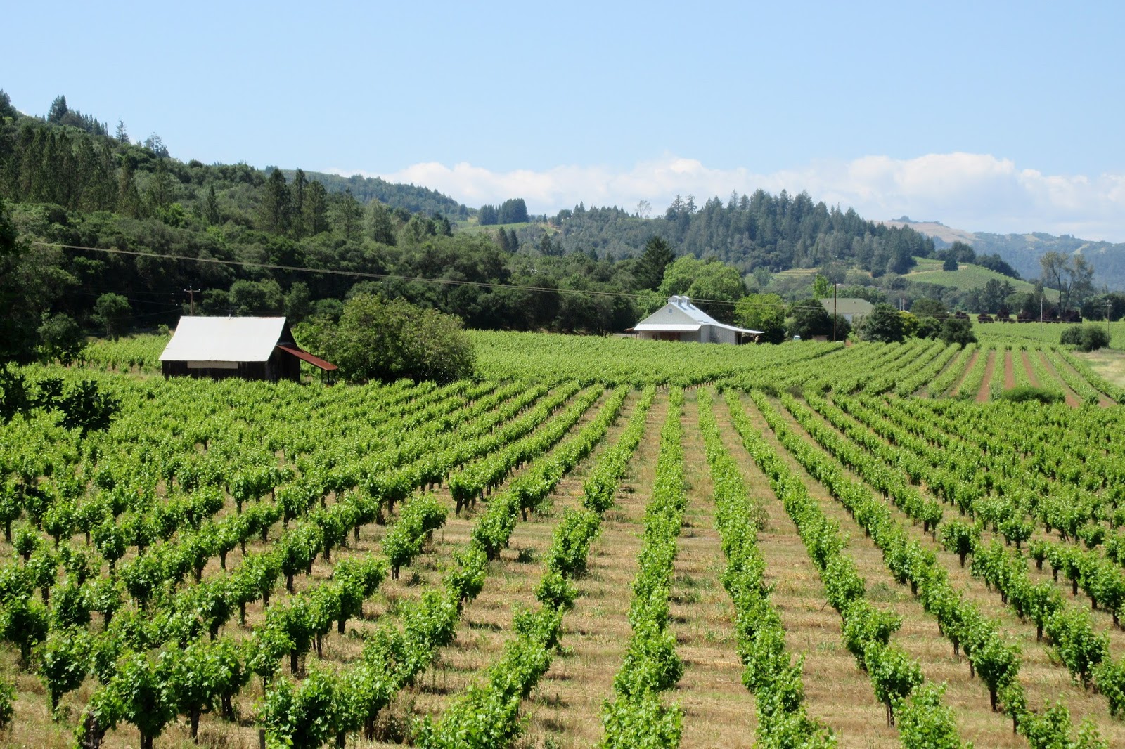 |
| Nice scenery for a bike ride. There are sixteen “Viticulture Areas” in Sonoma County that reflect the various micro-climates and soil conditions for growing particular types of grapes to perfection. The Dry Creek Valley is known for its Zinfandel and Sauvignon blanc. Vino is big business here, and Sonoma and its neighbor to the east, Napa, consistently produce some of the best in the world. |
 |
| This is the century-old Geysers Road Bridge, a 140-foot trussed span across Big Sulphur Creek. There were all sorts of rustic, photo-op gems on this backroads ride. |
 |
| Kevin would spin through the countryside and suddenly point to a winery and give you the lowdown and back story on the vintner. |
 |
| A vintner’s home. Classic Sonoma. |
 |
| Kevin’s wife, Denise, cooks up a delicious dinner. She’s an incredible lady who wears many hats around the Feldman home: chef; seamstress; organic gardener; raises bees for honey and chickens for eggs. Shared a lot of good times with her and Kev in the ‘80s when they lived in Riverside. I had hooked up with Kev for some adventures in Utah last month, but I hadn’t seen Denise in ten years. It was wonderful to reminisce and catch up during my visit. |
I can’t believe it!! I have come down with a bad cold. Must’ve picked it up in Tahoe, I dunno, but crap… King Ridge is out. Felt okay on the ride yesterday; thought maybe the sniffling and itchy throat was nothing more than a hay fever episode. Wishful thinking. As the night wore on, it just got worse and worse. I had Kev drop by the drug store so I could load up on Benadryl and Nyquil. Good thing, because I wouldn’t have slept a wink last night without it. Now my head is plugged up, I got a bad sore throat and a good Benadryl buzz going. But it’s beautiful outside. So after breakfast, we’ll head out and maybe ride something easy. Maybe. I’ll see how it goes after I eat something.
 |
| Cruising along the top of King Ridge. Kev had driven up two gnarly grades—each, about 1,500 feet of gain—before pulling over to park. There we jumped on our bikes. I was very much under the weather, but the spectacular scenery helped immensely to ease the misery. |
 |
| Moo. It's open range up here. |
 |
| Nope, not Ireland. King Ridge, Sonoma County. |
 |
| After about 4-5 miles and 700 feet of climbing, I was pooped. So we turned around and rode back to the car. Kevin then drove me around the remainder of the 50-mile loop so I could see it firsthand. Man. I’ve got to come back and ride the whole enchilada. |
MAY 11th –
Feeling better, but far from 100%. The irony is that I went all winter and had not a sniffle, and now… Boom. Talked to Ter yesterday: she feels fine. So I got this bug on my own. Kevin & Denise were awesome hosts, but now I’m off to San Francisco, starting the return leg of my travels. No riding today: I’m not up to it. The plan is to stay at Beth & Tom’s place tonight in SF. Visit. Rest. And then rest some more.
 |
| By mid-morning, I’m driving across the Golden Gate Bridge into the City. Here are six facts on this iconic landmark—which turns 80 next year—that you may not know… 1— The original design, submitted in 1921, was a clunky cantilever hybrid that critics said resembled “an upside-down rat trap.” After much debate, it was rejected. New engineers (rival bidders from the original RFP) were brought onto the project and they came up with a graceful suspension design that was unanimously approved. 2— The U.S. War Department fervidly opposed the project, fearing that an enemy surprise attack could bomb the bridge, trapping Navy warships in San Francisco Bay. The military eventually gave its approval, but insisted the bridge be painted in black and yellow stripes so it would be readily visible to passing ships in foggy conditions. The Army Air Corps then argued that it should be painted with red and white stripes so it could be more noticeable from the air. 3— In the 1930s, the rule of thumb on high bridge construction projects was to expect one fatality for every $1 million in cost. By those standards, the construction safety record for the $35 million GGB was well below the norm for the day: only 11 workers were killed. Chief project engineer, Joseph Strauss, made safety a higher priority, developing several unprecedented measures to reduce accidents. As an example, this was the first construction site in America to require workers to wear hard hats. 4— Three months after the bridge opened in 1937, H.B. Wobber strolled the span alongside a tourist he had just met on a bus. Wobber suddenly turned to his companion and said “This is where I get off” and then leaped over the side, becoming the first to commit suicide by jumping off the bridge. Sadly, over 1,600 people have killed themselves in this fashion over the years. 5— Most of the construction financing came from bonds sold by the Golden Gate Bridge District—very little was state/federal funding. Despite being in the midst of the Great Depression, voters in the District’s six counties approved a $35 million bond issue that required them to put their homes and businesses up as collateral. The last of the bonds were retired in 1971. 6— The signature orange color for the bridge was not intended to be permanent. The steel girders delivered to the construction site were coated in a reddish primer to protect them from corrosive elements. As the bridge was being erected, project architect, Irving Morrow, found that he preferred the vivid hue of the primer over the more conventional paint choices such as black or light gray. The red-orange color was not only visible in the fog, but it complemented the natural topography of the surrounding hills and the cool blues of the bay and sky. The custom color, GGB International Orange, is manufactured by Sherwin-Williams. |
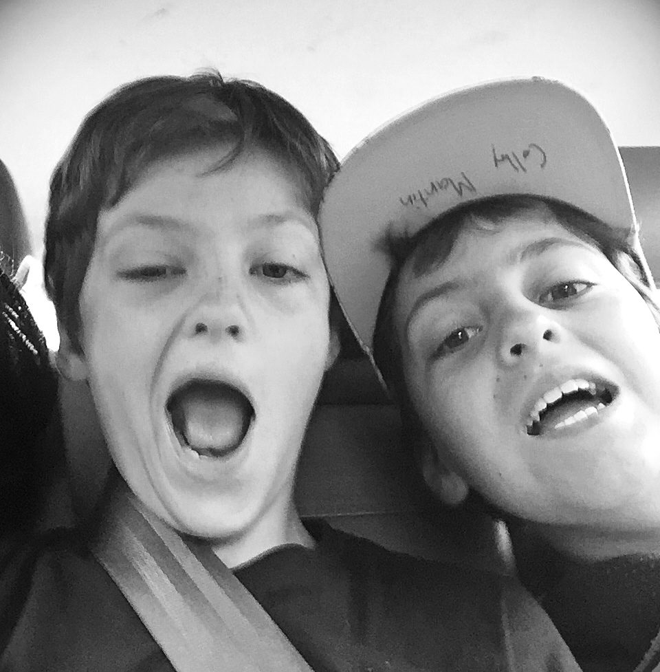 |
| My nephews, Nic and Colby, ham it up in the back seat on the way home from school. I had spent the afternoon visiting with Beth and running errands with her before picking up the boys. A family dinner at home was our plan for tonight. |
MAY 12th –
It’s my birthday today (sixty-something, can’t remember). I go downstairs, where Beth is heading out the door with a mug of coffee in her hand, off to work. Tom is in the kitchen, dressed in shirt and tie, preparing breakfast for the boys. I sit down and have a bite with them. Nic and Colby are full of energy—I need two cups of coffee to attain that level of exuberance. At 7:30, Tom herds them out to the car and off to school and office they go. As for me, the sore throat is gone, but now I’ve got a cough; the congestion has gone to my lungs. Oh well. Today’s objective: Big Sur. If I feel up to riding, would sure like to check out a stretch of Highway 1 along the coast.
 |
| Ride #5. I pulled off Highway 1 at the Bixby Bridge. Last night, I had scoped out a stretch of highway to ride that started here and went ten miles down the coast to Mill Creek. It was an out-and-back ride, so I could turn around anytime if I wanted. |
 |
| Looking back north at the elegant Bixby Bridge where I parked the car. Constructed in 1932, it is still one of the tallest single-span concrete bridges in the world. |
 |
| Livin' it. |
 |
| The first recorded documentation of this coastline was in 1542 by Spanish explorer Juan Rodríguez Cabrillo. Today it is quite possibly the finest road-cycling ride in the universe. |
 |
| I was constantly stopping to snap photos. How could you not? |
 |
| I reluctantly turned around at mile 10 and headed back to the car. The entire stretch from Big Sur to San Simeon is 65 miles. It should be on every cyclist’s bucket list. I know I’ll be back. |
 |
| I celebrated my birthday at the Sea Chest Oyster Bar on Moonstone Beach in Cambria with an excellent Chardonnay (from Sonoma, naturally) and sea bass baked to perfection, all the while the sun’s orange disk was sinking into the Pacific Ocean. A good way to end the day. |
MAY 13th –
Fog shrouds the coastline in the morning. Seagulls glide along the surf. I’m feeling even better today, and after checking out of the motel, I turn south onto Highway 1. I’ll be staying at my brother Jeff’s place in Carpenteria tonight. But first, I’m hankering to get in just… One. More. Ride.
 |
| Morro Rock looms off the coast, the northern-most of nine volcanic plugs that dot the landscape between here and San Luis Obispo. The Chumash, who lived in this area for centuries before Europeans arrived, consider this rock a very sacred site. |
 |
| On the road for Ride #6. I had taken Highway 1 to Lompoc and parked the car downtown with aspirations of riding from there out to the coast, a distance of 10 flat miles with a fierce headwind. |
 |
| Lompoc is known as the “Valley of Flowers,” and riding through the fields along country lanes is a vibrant encounter. |
 |
| Once the flower seed capital of the world in the '60s and '70s, Lompoc has seen a continuous decline in production ever since as growers moved operations to South America. More and more, farmers here are switching to growing vegetables as they’re more profitable. I rode through many fields in full bloom, but was told that it’s a fraction of what it used to be. |
 |
| NASA Space Launch Complex 2 stands in the distance at Vandenberg Air Force Base. There are six active space launch facilities spread out across the base, and another 6-7 pads that are used by the military for ICBM and anti-missile testing. (No doubt a few rocket scientists live around here.) From where I snapped this photo, it is—quite literally—the end of the road. There is limited access to the pristine beach and NO TRESPASSING signs everywhere. And so, after a brief look-around, I started back to Lompoc. I had a dinner date in Carpenteria with Jeff & Ramona. |
MAY 14th –
Saturday morning, Ramona is in the kitchen cooking up an incredible breakfast. Jeff and I visit at the table with mugs of java. Alas, it will soon be time for me to head home. But I’m ready. I miss my sweetheart. (And I know she misses my cooking.)
 |
| Jeff and I hang out in his back yard before I hit the road. It has been a remarkable trip. By the time I reach home, I will have completed a thousand-mile circuit around this Golden State of deserts, mountains and sea, the highlight of which was Doug & Brianna’s wedding where good times were had by all. But what enriched the journey so well were the bike rides—albeit brief in some cases—that I was able to fit in, and of course, the treasured visits with friends and family along the way. Yes, it was a drag catching a cold. And a super-drag to miss out on the mighty King Ridge ride. But that’s okay. As an old geezer who just celebrated another birthday, all I can say is—don’t sweat the small stuff. I’m alive and breathing. I’ll be back. |
To see all of Doug & Bri's wedding photos, click here...
https://www.flickr.com/photos/91696789@N00/albums/72157668677018411
The remainder of the Tour de California pics are here...
https://www.flickr.com/photos/91696789@N00/albums/72157669295783241