Terry found the trip online: "Five Days in the San Juan Islands". In a kayak. On water. With killer whales under the water. In a nutshell, my wife grew up sailing on Long Island Sound, so perishing at sea is in her blood. At least that’s my perspective. I can count on one hand the times I’ve been in a sea kayak—and those were day trips on docile waters. But five consecutive days of paddling in the Salish Sea?
“Come on, what’s not to like about this trip?” she posed.
Okay. Up to a point, she had a point. We would be navigating through a stunning archipelago off the Washington coast, exploring enchanted isles, sleeping under the stars, communing with eagles and seals and, yes, possibly even those humongous
orcas that lurk under the waves. It did sound enticing. From the time I first laid eyes on the San Juans three decades ago from the railing of a Canada-bound ferry, I was hooked on their mystique and rugged beauty. Terry and I had visited Orcas Island in 2008. We had hiked to the summit of Mt. Constitution—the highest point in the island chain—and stood in awe over the panoramic view of all those islands spread out before us. We both felt compelled to return some day. And here we were, nine years later, ready to do some in-depth exploring.
We booked the trip with Anacortes Kayak Tours, which Ter had selected due to their unique trip itineraries and stellar Yelp reviews. AKT would handle all of the logistics, gear, and food. All we needed to do was show up at the point of departure with our clothes and sleeping bags. Our journey would begin on San Juan Island, out at the west end of the island chain, and end five days later at the ferry/seaport town of Anacortes on the mainland. In all, we would be paddling about 45 miles. Rain or shine.

We arrive in Friday Harbor on San Juan Island on a Saturday afternoon, taking the ferry out from Anacortes. Our kayak trip doesn’t begin until Monday, so we have tonight and all of Sunday to explore the island before we depart. Friday Harbor is a quaint little town of 2,300 people, the largest town in all the San Juans. It was named after Joe Poalie Friday, a native Hawaiian who herded sheep here for the Hudson Bay Company in the 1870's. Just sixty air miles from Seattle, it is a bustling place at the peak of summer, but sleepy and tranquil in the winter—at least that’s what a local told us, who prefers the town in its off-season sleepy state.
Dining on the Friday Harbor waterfront.
On the road to Cattle Point at the south end of San Juan Island. We rented scooters for Sunday. Ter had never operated a motor bike of any kind before, and she was a little apprehensive at first. I told her it was no different from her mountain bike, other than this had a throttle. Piece of cake. The island is 55 square miles, so touring the countryside on scooters was definitely the way to go.
A red fox saunters over to where we’ve stopped at a turnout. He was looking for a handout, practically doing handsprings to get us to feed him. Dude. Go catch a vole.
The
Pelindaba Lavender Farm was one of our stops, where the San Juan Island Lavender Festival was in full swing, complete with a trippy marimba band. We roamed through the fields, listening to the music, and sampled the homemade lavender/vanilla ice cream
(pretty good) and lavender brownies
(tastes like soap). There are 25 acres of
Lavandula of numerous species being cultivated here.
This stainless steel sculpture, called
Pi in the Sky, sits in the middle of a lavender field. Several local artists were showing their work at the festival. Cool stuff.
A century-old lighthouse stands vigil on Lime Kiln Point on the west side of the island. Off in the distance, on the other side of the Haro Strait, is British Columbia, Canada. In the mid-19th century, the San Juan Islands were claimed by both Great Britain and the United States, with settlers from both countries beginning to move in and homestead parcels of land. Things escalated until an American farmer shot a pig that was rooting in his garden—a pig belonging to a British subject—and thus sparked the
Pig War. It took years to straighten out. Ultimately, it was negotiated that the Canadian/American border would run down the middle of the Haro Strait, giving the San Juans to the United States. As for the dead pig … it was the only casualty in the conflict.
. . . . . . . . . . . . . . . . . . . .
JULY 16th –
Enjoyed a great day touring San Juan Island on motor scooters. We did a full loop, about 40 miles. Beautiful coastline! Afterwards, we had dinner again on the Friday Harbor waterfront. Now we’re in our motel room, sorting gear and setting aside what will go on the kayak trip. The things we don’t need will be given to AKT, who will then ferry it back to Anacortes and store it in their office until the end of the trip. Ter is fretting about getting cold at night. Finally, she tosses another layer of warmth onto the “kayak” pile. On the TV, the weatherman predicts a chance of rain by mid week. Reality sets in: We’ll be paddling for five days, rain or shine. But we’re ready for it. We’re stoked.
. . . . . . . . . . . . . . . . . . . .
There’s a flurry of activity on Smallpox Bay in the morning as kayakers prepare to launch. It’s a popular put-in site on the west side of the island. We arrived on time, but there had been a snag: the ferry bringing our kayaks and guide out from Anacortes had broken down. When they finally arrived
(the three nearest kayaks are part of our group), we quickly loaded up and shoved off.
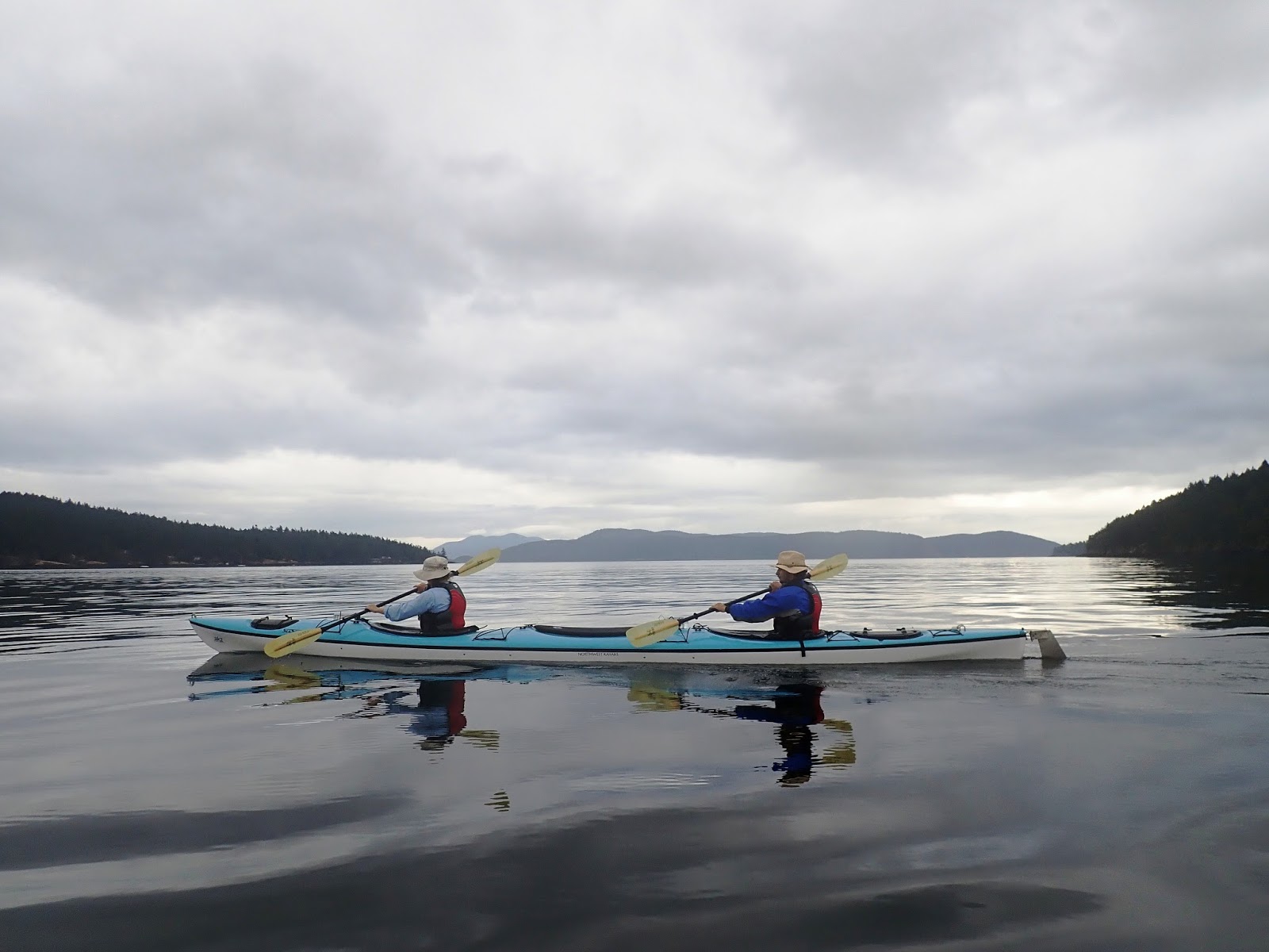
After a 2½-hour delay on getting started, we are on the water and paddling north, up the coast of San Juan Island. There are four kayaks in our AKT flotilla: two tandems and a pair of singles. Terry and I got the yellow tandem, where my wife jumped in the forward cockpit and appointed herself captain. I’ve got the aft seat, which operates the foot pedals that control the rudder. It took some time for me to get the hang of steering, for I was constantly over-correcting, or my foot would pop off one of the pedals, and Captain Bligh would snap: “More to the right! …Left! …You’re off course! …No, right!” It was all new to me: synchronizing our paddle strokes; maintaining a fluid rhythm; staying balanced and on course. The cross-wind and sea currents certainly didn’t help matters, either. But as the day progressed, my piloting skills improved. Otherwise, there would’ve been a mutiny.

Our AKT guide, James, leads the way across the glassy surface of a kelp forest off Spieden Island. These underwater forests along the shorelines dampen the waves and sea currents, making for a mellow paddle over the top of them. Seals and salmon use them to hide from killer whales.
Zenzi cruises along the shoreline of Spieden Island. She’s one of the four clients on the trip, and the only client who has any kayaking experience. As for Spieden, it had this "Mysterious Island" allure going for it. In the early 1970's, it was used briefly for hunting big game. Exotic animals, including lions, tigers and rhinos, were brought in, where game hunters then paid for the privilege of shooting them. From a van. The proprietors of the operation called it
Safari Island. But the general public, once they discovered what was going on, called it an outrage, and before too long, it was shut down. Today the 500-acre island is owned by James Jannard
(founder of Oakley), and nobody lives here but the resident wildlife, which includes Mouflon sheep from Corsica, and Sika deer from Asia.
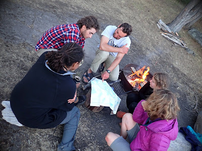
James stands back as his guide apprentice, August, shows off his culinary skills. We made camp for the night on Stuart Island. We’re sitting around the table here, hors d'oeuvres and Glenfiddich close at hand, watching these guys whip up an incredible dinner. Camp chefs, extraordinaire.
A short hike up the hill from camp is the
Stuart Island School. Pictured are the old classroom
(left) and library/office. A more modern building—with indoor plumbing—was added nearby in the meadow in 1980. Even today, only about forty people live on the island year-round, and hence the school never saw more than a handful of students. In fact, it closed down in 2013 because there were no kids to teach.
Looking across the Haro Strait into British Columbia. At sunset, we all hiked up the steep, faint trail to the summit of Stuart Island, and caught this magnificent view along the way. Stuart is the northern-most island of the San Juans, and it’s not very big
(less than three square miles). To live here means living completely off the grid. There are no restaurants, stores, or markets. There is also no ferry service, which is how the island has managed to preserve the pristine, wilderness ambiance that many of the others in the archipelago have lost. And that is precisely the way the residents here like it.
. . . . . . . . . . . . . . . . . . . .
JULY 17th –
Our first day on the water was a long one. We paddled around 11 miles, getting a late start and arriving at camp later than anticipated. James and August cooked up a great pasta dinner. There are six total in our group, giving the trip an intimate feel. The two other clients, Zenzi and Allison, are wonderful ladies. Zenzi is from Austin. Allison comes from St. Louis. We make a good bunch, with lots of gaiety around the camp table. After dinner, we went for a hike and scaled the island's summit at sundown. Spectacular! We came back down through the woods at nightfall, owls hooting in the dark. Now we’re in our tent, rubbing sore shoulders and backs—and taking more ibuprofen. We are total newbies at this kayak thing, but loving it. More miles to pull tomorrow.
. . . . . . . . . . . . . . . . . . . .
Day 2: After breakfast and breaking camp, we all lend a hand to carry the gear down to the beach, where James meticulously stows it away. I am amazed at the amount of cargo these kayaks can carry.
Departing Stuart Island, across a windless, Salish Sea that's as smooth as glass.
We stop for lunch in a driftwood cove on the northeast side of San Juan Island. Warm and sunny, it’s a perfect beach day.
Our campsite on Jones Island is possibly one of the best in the universe. It even had a tree swing! But oddly, James was very averse to ever camping on this island again.
“Raccoons,” he warned. “They’re out of control.”
“It's the Raccoon Mafia,” August added with a perfect Sicilian godfather accent.
James expounded on how the wily critters raided your camp after dark; tore into packs; tried to steal your food; kept you up half the night. However, we had already paddled nine or ten miles today, and the next potential campsite was several miles further along. That didn’t sound very appealing, either. So, James left it up to us, the paying customers. And we chose to take our chances on Raccoon Island.
A poster on the Jones Island message board.
 |
| photo by Zenzi Griffin |
A dining table with a view. Sitting across from me is Allison from St. Louis. She had just graduated from college, flew out to Portland, bought a used truck with a camper shell, and then drove up to Seattle for this kayak trip. Afterwards, she’ll drive up to Squamish in BC to go rock climbing, and then meander down to Yellowstone and Jackson Hole, and who knows where else in the West. She’s on an adventure.
After dinner, James brought out his chart and we gathered round. As our guide, he had invaluable knowledge for navigating through this maze of islands. On the chart, he had marked small arrows, red and green, at key channels between the islands. The red arrows indicated the sea current’s direction during ebb tide. The green arrows showed the direction during flood tide. Using an app on his iPhone, he could then synch with the latest tide tables and interpolate the speed and direction of the current at various locations over the next 24 hours. This was important, because the peak-tide velocities in the narrower channels could be significant.
(Case in point, Deception Pass, which we would NOT be going through.) After he had the tides dialed in, James then checked the latest weather forecast, and from all of this information, he plotted our intended route for tomorrow, seeking the path of least resistance. “Threading the needle,” he called it. Bottom line: A front was moving in, and we would be paddling into a headwind first thing in the morning.
Day’s end on Jones Island. This serene isle is much smaller than Stuart
(about 180 acres), and a Washington state wilderness park in its entirety. There’s nothing here but campsites, secluded coves and hiking trails.
. . . . . . . . . . . . . . . . . . . .
JULY 18th –
Another splendid day—though the shoulders are sore again. We left the rainfly off so we can gaze up at the stars tonight. The latest forecast calls for a chance of rain the next two days, but it's remarkably clear right now. The wind is sighing through the trees. Waves lap rhythmically onto rocks. The campfire crackles and pops. It’s utter enchantment. Haven’t seen any raccoons lurking about, but still ... to allay the worries, I helped James and August suspend all of our food from a high tree branch (including our good Scotch). It’s bomb proof, no way can they get it. Pretty sure.
. . . . . . . . . . . . . . . . . . . .
TO BE CONTINUED...