In the last episode, we left our six, intrepid kayakers digging in for a long night on Raccoon Island. Their fearless leader, Cap’n James, had warned of the devious ‘Coon Pirates who raided the camps late at night, and had directed the work on fortifications to thwart them. In addition, the expedition’s food supply was hung from a sturdy tree branch, out of harm’s way. If any critters were to resort to thievery, Aide-de-camp Augustus had been charged with bludgeoning them with big rocks. “We must steel ourselves for the worse and hope for the best,” proclaimed Cap’n James, for they all knew that to lose their food
(and whiskey) would jeopardize the mission. They had paddled twenty miles the first two days of the journey. But to reach the Holy Grail of Anacortes, there were still another twenty-five miles to go. Hence our saga continues, as to the fate or glory of James, Augustus, three daring ladies, and an old dude.
Day 3: The morning pack-up on Jones Island. The day greeted us with sunny skies, but the wind had strengthened during the night and was now kicking up whitecaps out in the channel. There had been no raccoon raids during the night, much to everyone’s relief. Hanging the food in the tree and keeping a spotlessly clean campsite had done the trick—either that, or the varmints had all been deported.
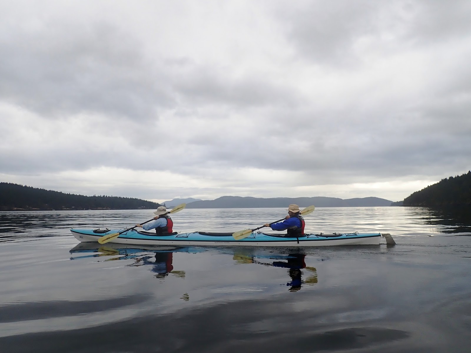
The first two miles of the day are across open, choppy seas, paddling into a brisk headwind. The bigger waves broke over the bow, and the wind would fling the spray into our faces. Being in the forward cockpit, Ter caught the brunt of it. It was demanding work with no rest, the most challenging section yet of the trip.
From the still waters of a kelp forest eddy, James watches August and Allison turn into the tidal current. I was beginning to grasp how to read the water’s surface to locate the boundary lines between currents and eddies. James had led us up the south shoreline of Crane Island, from eddy to eddy, to avoid the majority of wind and current, both of which were flowing against us. The small island above James’ hat is Bell Island, which is where we are heading next. The larger landmass and mountains beyond Bell is Orcas Island.
This is our camp on Blind Island, a tiny isle that sits at the entrance to Blind Bay on Shaw Island. We had come ashore early in the afternoon and called it a day, set up the tents, and then paddled across to the Shaw Island ferry dock
(across the bay in photo) for ice cream.
It seemed that our happy hours were commencing a little earlier each night.
The sunset view from Blind Island, which is less than three acres in size, the highest point being forty feet above sea level
(where this photo was taken). A German immigrant, John Fox, homesteaded here in the early 1900’s. However, the island’s solid bedrock prevented him from drilling a reliable well, and the cisterns he built couldn’t supply enough fresh water. The homestead was eventually abandoned, and all that remain are a few structure footings and plugged holes. Supposedly, John Fox is buried here somewhere, but no signs of a grave exist. The island is now a state park and has four, primo campsites.
. . . . . . . . . . . . . . . . . . . .
JULY 19th –
We only logged about six miles today, but the first two were a bitch, paddling into a stiff headwind. Fully loaded, our tandem kayak handles like a container ship: not the least nimble, but it takes the waves pretty well. We made camp on Blind Island, a small isle at the entrance to Blind Bay. After lunch, we paddled across to the Shaw Island ferry dock and bought ice cream at the general store. I asked the young man serving up the ice cream cones how many people lived year-round on Shaw, and he said about 250. Life goes by slow and quiet here. There’s no rush. We sat outside in weathered chairs overlooking the bay and savored the afternoon. Back at camp, we launched into happy hour, then dinner, and then gathered round a warm fire, roasting marshmallows, and discussed tomorrow’s plans. Storm clouds are rolling in. The weather is changing. It’s noticeably colder tonight than last night, and there’s a chance of rain in the forecast.
. . . . . . . . . . . . . . . . . . . .
Day 4: Under ominous skies, Allison and August make the crossing from Shaw Island to Orcas Island. We had a big day ahead of us—in addition to a chance of rain—so James had us starting extra early to catch the flood tide just right.
A purple sea star
(Pisaster ochraceus) clings to the rocks along the shore of Orcas Island. Catching low tide first thing in the morning, we came across scores of these fascinating creatures. They are considered a
keystone species in the tidal zones of the San Juans.
 |
| photo by Zenzi Griffin |
More sea stars. These are orange. There are also burgundy red ones. Why the different colors? Check out
Dr. Mah’s research.
We drift with the current for a short break, musing on Blakely Island in the distance, and the 4,000 yards of open water we must cross to reach it. An hour or more is what it will take to paddle across. The skies have been dark and threatening all morning, but so far, no rain. Hopefully our good luck will persevere.
An old bronze bell hangs on the jetty at the Blakely Island Marina. After the crossing from Orcas Island, we stopped here for coffee and pastries at the general store. There are about sixty year-round residents on Blakely.
We head into Peavine Pass, the narrow channel that separates Blakely Island
(right) and Obstruction Island
(left). James had timed it perfectly, for we were riding a two-knot flood tide through here. Supplemented with paddle strokes, we were scooting along at four to five miles per hour.
Pelican Beach is our camp for the night, an alluring cove on the northeast end of Cypress Island. There were several sailboats anchored offshore, some of them a group of friends who had come out from Anacortes to camp, all of them amiable folks.
This handsome ketch was anchored off Pelican Beach. We were admiring it from shore, when a young couple sitting nearby said: “That’s our boat.” No kidding? It was a vintage, all-wood vessel in pristine condition. Turned out, they had purchased it just two weeks ago. They had quit their jobs and were making it their home, with plans to eventually sail abroad. Would we like to come aboard for a tour? Uhh… Yeah!!
Aboard the
Ursa Major with owners Hayden & Michaela, and their yellow lab, Alex.
Not a bad rig for cruising around the Salish Sea, living the dream.
 |
| photo by Zenzi Griffin |
The
Ursa Major’s main cabin. It’s kind of like living in our camper van. Except our van is smaller … and would sink if you put it in the water.
Yet another gorgeous sunset. We had hiked to the top of Eagle Cliff, 750 feet above camp, to watch it. Hayden and Michaela had joined us, and several of our camp neighbors were on the summit as well. The air was still, and a hush came over our eclectic group of voyagers as everyone gazed at the technicolor sky, soaking in all the beauty and good vibes. If we were to keep a “Best Sunsets Ever” album, this would be one of them.
On the summit of Eagle Cliff.
. . . . . . . . . . . . . . . . . . . .
JULY 20th –
What a day! We broke camp extra early, the skies dark and brooding; beat across 2+ miles of open water to Blakely Island, where we had coffee and pastries at a sleepy marina; shot thru Peavine Pass on a flood tide; dodged rain; beat across the Rosario Strait (another 2+ miles of open water); paddled around the north end of Cypress Island; made camp on beautiful Pelican Beach; took a tour of a real pirate ship; made new friends; Glenfiddich; a tasty dinner; an evening hike to the summit of Eagle Cliff to watch the sunset; and finally, crawling into our tent on the beach and calling it a night. I’m guessing we paddled about 11 miles today—about the same as our first day, but this time, feeling much stronger afterwards. I think we’re getting the hang of it. Or maybe it’s the lightened cargo of food and whiskey?
. . . . . . . . . . . . . . . . . . . .
Day 5: In the morning, just before launching, we had one of our camp neighbors take some group shots. You gotta have a good group shot that captures the theme of the trip.
(No, not Gilligan’s Island. More like Treasure Island.) The AKT Flotilla lineup, L-R: Zenzi, Ter, yours truly, Allison, Aide-de-camp August, and Cap’n James.
James points out the route that we’re taking this morning: down the east shoreline of Cypress Island for a spell, and then across the mile-wide channel to Guemes Island. The snowy ramparts of Mt. Baker can be seen faintly on the horizon at far right.
 |
| photo by Zenzi Griffin |
Always looking for that perfect shot. The advantage of being in a tandem kayak was that I could stop paddling and snap photos while Ter kept pulling. However, it annoyed her to no end when I’d say: “Pick it up, babe, we’re falling behind.” What she didn’t know was that I’d already calculated that I was sitting far enough aft to be out of swinging range of her paddle. But it never crossed my mind that she could throw it at me.
We came ashore for lunch on an empty beach on the west side of Guemes Island. Guemes is eight square miles in size, with about 600 people living on it—including August. Since it would be our last meal together, James pulled out the camp stove and whipped up some grilled cheese and jalapeño jelly sandwiches. Out. Of. This. World.
After lunch, we pull around the south end of Guemes Island where Anacortes is suddenly dead ahead on the mainland
(directly above Ter’s hat). We’re coming into the home stretch.
Cruising along the Anacortes docks and relishing the last mile of the journey. We had paddled about forty-five miles in five days, far exceeding any distance Terry or I had traveled in a kayak before. We explored nine islands in the San Juan archipelago, made new friends along the way, and somehow, managed to dodge the rain and escape the wrath of the Raccoon Mafia. Sadly, we did not see a single killer whale, which, we were told, is unusual. The best we had going for a “Wild Kingdom” moment was
two bald eagles killing a baby seal. So what was the best thing about the San Juans? Besides the terrific people who shared the journey with us, we would have to say it was the awesome sunsets. We’ll never forget those sunsets.
There are 172 islands in the San Juans, ranging from 50+ square miles to an acre in size, to which we set foot on only nine of them. Here they are…
SAN JUAN - Second-largest island in the archipelago, but largest in population (7,000). Still very rural, and the best way to explore the island is on a scooter, which you can rent from Susie Doyle, proprietor of Susie’s Mopeds. We stayed in Friday Harbor for two nights before the trip, and also came ashore for lunch in a cove on the east side of the island on our second day of kayaking.
POSEY - A tiny, one-acre isle off the north coast of San Juan Island. We stopped here for lunch on the first day. There are two or three campsites.
STUART - The northern-most island of the chain, with a population of around forty who live off the grid. We camped here the first night.
JONES - A small, wilderness island off the southwest coast of Orcas Island. Incredibly scenic. We camped here for our second night.
BLIND - Three acres of rock and trees at the entrance to Blind Bay on Shaw Island. Four secluded campsites; excellent views in any direction. We stayed here for our third night.
SHAW - We came ashore for ice cream and beer (not consumed at the same time).
BLAKELY - Sparsely populated, similar to Stuart Island. We pulled in at the marina on our fourth morning for coffee and donuts.
CYPRESS - Picturesque mountains and forests, mostly wilderness. A gem. We camped here on our last night, and also came ashore earlier that day for lunch.
GUEMES - At the east end of the island chain, just three-quarters of a mile off Anacortes on the mainland. We stopped for our last lunch on a vacant beach.
. . . . . . . . . . . . . . . . .
If you'd like to see all of the photos from this trip, click HERE.
We also spent several days in Seattle, before and after the kayak trip, visiting my sister, PJ, and Ter’s brother, Mike. If you'd like to see the photos of us knocking around the Emerald City, click HERE.