Thursday, October 30, 2014

City of Gardens


The third and final leg of our British Columbia vacation took us across the Strait of Georgia to Vancouver Island. We boarded the ferry at Tsawwassen and steamed through the scenic San Juan Islands to Swartz Bay, where we then disembarked and drove on to Victoria. Terry’s bike accident in Pemberton had put a pall over the prospects of what we’d be able to do for the rest of the trip. The doctor in Whistler had warned that she not even think about cycling, or anything else physically demanding that could strain her knee and make matters worse. So we got online and searched for ideas. And are there cool things to do in the City of Gardens without having to get on a bicycle and break your neck? You betcha.    


We arrived in Victoria, the provincial capital of British Columbia, late in the afternoon, and soon after checking into our bed & breakfast inn, we strolled down to the harbor to look around. It is one of the oldest cities in the Pacific Northwest, established by Great Britain in 1843 initially as a fort and naval base. Located on the Strait of Juan de Fuca at the southern tip of Vancouver Island, it was strategically sited to thwart any Yankee incursions northward.


Having dinner with my beautiful wife at an outdoor cafĂ© on the marina is one way to express “Life is good”.        


A 25-year-old English immigrant, Francis Rattenbury, an auspicious young architect with no resume of accomplishments as yet, was awarded the contract to design the Parliament Building. Influenced by the Baroque and Romanesque Revival styles that were popular in late-Victorian times, the project far exceeded its budget and took five years to build. But when it opened for business in 1898, it was to immense fanfare and launched Rattenbury’s career as a successful architect.  


An evening stroll brought us to the renowned Empress Hotel, where we just had to go inside and snoop around a bit. This is another of Rattenbury’s architectural designs, completed in 1908. The five-star hotel has 477 rooms, four restaurants, two ballrooms, an indoor pool and a luxury spa. Back in the day, kings, queens and tycoons stayed here on a regular basis. In the 1960s, during a major renovation project, the “Empress” sign over the entrance was added and the bluebloods were appalled. In their opinion, if you didn’t already know it was the Empress, then you had no business staying there.


No trip to Victoria would be complete without a visit to Butchart Gardens, where pathways wander through 55 acres of botanical wonder. It sees almost a million visitors each year—they literally arrive by the busload—so to get a jump on the crowds, we made sure to be at the front gate when it opened. The grounds were originally part of a limestone quarry operated by Robert Butchart, who made a fortune manufacturing and distributing Portland cement. (The kiln chimney in upper right corner of photo is the last remnant of the cement plant.) Starting in 1906, as the quarry began to play out, Robert’s wife, Jennie, hauled in tons of topsoil and fertilizer from the surrounding dairies and slowly transformed the scarred landscape into a private Garden of Eden. She had quite the green thumb, and over the years, the gardens were expanded until they encompassed the large home they had built there. Today it is a thriving enterprise, still owned and operated by the Butchart family.


Maintenance is a gargantuan endeavor at Butchart Gardens. Depending on the season, there are 45 to 60 full-time groundskeepers, some of them professional arborists, horticulturists and landscape architects. I’m thinking they must have one big gnarly tool shed.


The Japanese gardens were my favorite. Though they lack the vibrant colors of the English and Italian gardens, the impeccable harmony of landscape and hardscape makes one desire to just linger and meditate.  


Hanging out in the Japanese gardens.


Fountain statue in the Italian gardens.


Giant sunflower.


The small placard next to this rose bush said: “Maggi Barry” – New Zealand, 1993. Ha! I must snap a photo of this. And as I move in for a close-up shot of one of the blossoms, a middle-aged couple walks up to ogle it.

“Hey look,” the woman says to her husband. “I gotta take a picture of this and send it to Maggi. They named a rose after her.”

Huh? I stood up and looked at her. “That’s my sister’s name,” I told her.

Small world.


     ~~~~~~~~~~~~~~~~~~~~~~~~

After an enjoyable day at Botchart Gardens, we drove back into Victoria, deliberating on what to do next. It was mid-afternoon. We could check out the Royal BC Museum. Maybe see Craigdarroch Castle? Or a harbor cruise? In the end, we returned to the Rosewood Inn for a little R&R at the B&B. Ter needed to rest her knee. But also, I was starting to get pangs in the gut, maybe indigestion, and all I wanted to do was lie down and recoup. And of course, that’s how it always begins. I know that now.

Within twenty minutes of returning to our room, I was writhing in agony on the bed, waves of pain so intense that I couldn’t think straight or carry on a conversation. It felt like somebody was driving a dagger into the left side of my abdomen, and then sadistically twisting the blade. I’ve only felt such incredible pain once before, about four years ago, and so with dreaded certainty I knew the probable cause: A kidney stone.

I told Terry: No effing way am I going to the ER in a foreign country on my vacation. No. Way. Period. But when the third tsunami of pain knocked me to the floor, and I was calling out for morphine, she promptly got directions to the nearest hospital from the desk clerk and we were on our way.

Royal Jubilee Hospital was a nice-looking facility with shiny glass facades. Inside, the Emergency Care Admissions lady asked to see my Care Card. Every Canadian has one. Instead, Ter pulled out my Kaiser Permanente card and placed it on the counter. The lady tossed it back at her. It was worthless here. The only cards they took from foreigners were Visa or MasterCard, and I was in too much pain to negotiate.

Once they had my credit card number, we were directed to the ER waiting area, which had the ambiance of a crowded three-ring circus. I was instructed to sit on a bench seat outside the lab and wait for them to draw a blood sample. An hour later, we were still waiting. The two technicians who were working the lab casually ignored us.

Meanwhile, a disheveled fellow was escorted back by an armed security guard and instructed to sit on our bench seat, right next to Terry. Once the guard departed, the guy began to moan, pleading with every nurse and doctor that passed by. He clutched his stomach and bellowed that his appendix was going to burst any minute. He needed pain meds. Now. Please. Turning to Terry, he lamented that he was fifty-five years old and was going to die. In response, the much-older man sitting on the other side of him said: “Oh, hush up. I’m eighty-seven. You’re not going to die.”

As the two men argued over who was going to croak first, an RN called my name and ushered me into one of the exam bays. His name was Kyle, a buff dude; military haircut; tattoos on his arms and neck; possibly ex-JTF2, which is Canada’s Special Ops force. Who knows? One thing for sure, he totally knew how to insert an I.V. catheter. Smooth as silk. He was done before I knew he’d started. But when he found out that the lab tech hadn’t drawn my blood yet, he rolled his eyes and led me back to the bench where Terry was sitting and told me to wait there.        

By now, almost two hours had passed. Lucky for me, the pain was subsiding, so when Kyle returned with a hypodermic syringe full of morphine, I held up my hand. Wait a minute, I told him. I had no desire to be flying high as a kite right there in the waiting room—especially a waiting room that reminded me of a three-ring circus. Maybe I didn’t need the heavy artillery. He tried to persuade me otherwise, but I shook my head. Finally, as a compromise, he injected me with a cocktail of anti-inflammatory drugs and I’d wait to see how things went.

While all this was going on, the disheveled chap who was sitting next to Ter—the same guy who’d been moaning in pain earlier and was convinced he was dying—gazed pensively at the syringe of morphine. He never took his eyes off it. And when Kyle was finished and walked away, the guy quietly stood up and marched out of the ER, his burst appendix apparently healed. Which goes to show, miracles do happen.

In due course, an attendant paged me and I was led to another exam bay, where a doctor soon arrived and apologized for the long wait. He examined me thoroughly and asked a load of questions. By now, I was no longer having the pain attacks at all. Maybe I’d passed the stone? It was possible. Nevertheless, as a precaution, he wrote me a prescription for Ketorolac and told me to take it easy. Thirty minutes later, I was released.

And the lab techs never did draw my blood.

     ~~~~~~~~~~~~~~~~~~~~~~~~


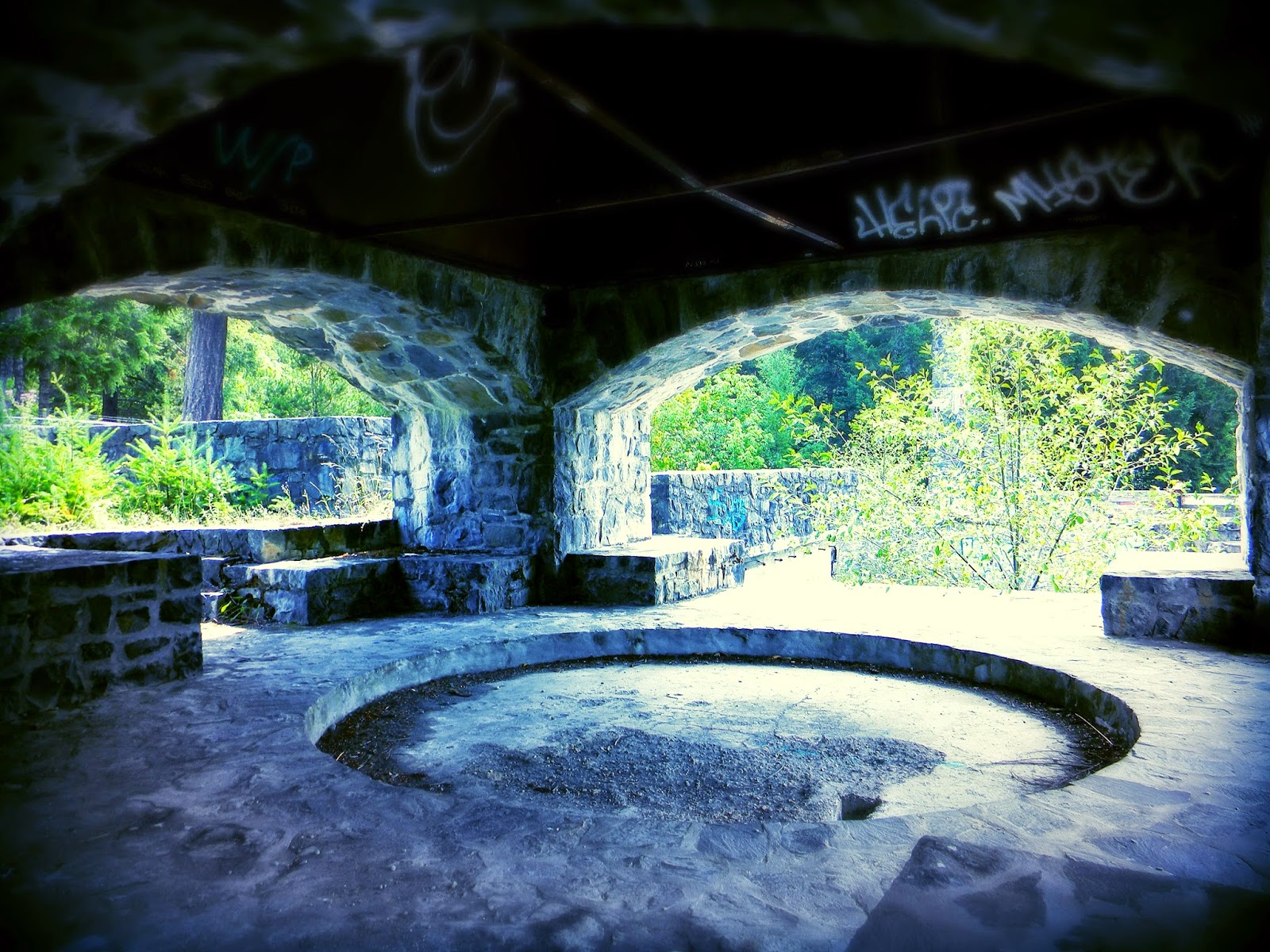
The next morning, we drove 25 miles down the coast to the Sooke River, and then followed it upstream for a few more miles to the Sooke Potholes Provincial Park. I had read beforehand that this area was one of Victoria’s best kept secrets. It was off the tourists’ map, mostly locals came here. We parked in a dirt pullout and walked down a pathway to an incredible overlook of the gorge. It was a sheer drop of 400 feet to the river. But the best part was yet to come: This is where you’ll find the ruins of the Deer Trail Chateau.


In the early 1980s, Victoria developer Albert Yuen bought a prime, 160-acre parcel along the Sooke River with intentions of building a resort and conference center. He christened it the Deer Trail Chateau and literally built the foundations at the very precipice of the gorge. Construction ensued in fits and starts for the next decade. The framework went up. A roof was added. But then investors got cold feet, funding dried up, and the project was abandoned.


The massive, four-sided fireplace at Deer Trail Chateau was large enough to roast an entire ox. For perspective, the archways are about six feet tall and twelve feet wide.


Stairways lead to nowhere throughout the ruins today. All of the decaying wood walls, flooring and roof were removed several years ago for fear of it collapsing or catching fire.


This is an old photograph of the abandoned Deer Trail Chateau before the timber and roof were removed. After a fierce, decade-long battle over what to do with the property, a land conservancy group bought it in 2004 with intensions of creating the Sooke Potholes Provincial Park. The little town of Sooke cried foul: They were under the impression that the land would be sold to another developer, who would then build some sort of resort that would bring jobs and tax revenue. In the end, the conservancy won out. The land is now part of the Provincial Parks system.


Directly under the chateau ruins, the Sooke River spills into a string of large pools. These are the “potholes” to which the park gets its name. Incredible high-diving here—though getting to some of these pools can be daunting.


Part of our hike along the Sooke River was done via the Galloping Goose Bikeway. A century ago, this was the roadbed of a narrow-gauge railway that extended up the river to Leechtown, a gold-mining settlement of which little remains. You can catch the bikeway in Victoria, where out to Leechtown and back is 68 miles. It is flat, mellow riding through mostly rural or wilderness scenery. We stopped and chatted with a Vancouver couple who were riding it. They had boarded the ferry with their bikes yesterday, and then rode into Victoria and stayed at a B&B. Today they were riding the Goose. Tomorrow they would pedal back to Swartz Bay and take the ferry home. Big smiles adorned their faces. So I wager we’ll have to put this on our tick list if we’re ever in Vic again.  


We stopped off to see Hatley Castle on the way back into the city. It was built by coal-mining/railroad magnate, James Dunsmuir, in 1908, and featured the finest in oak and rosewood paneling throughout; teak flooring; giant stone fireplaces; a steam heating system; and the latest in new-fangled electric lights and appliances. Total living space was over 25,000 square feet. And yes, it cost a fortune. But as Mr. Dunsmuir was quoted as saying: “Money doesn’t matter, just build what I want.” The highlight of our visit was me chasing a large gaggle of Canadian geese across the South Lawn. Crazy Americans.


Our stay at the Rosewood Inn was exquisite (again, thanks to LeRoy). It’s located in a historical district near the harbor, where just about everywhere is walking distance. On our last night in town, we strolled down to a local eatery that the desk clerk had recommended. We passed by house after house that had been restored, many of them quite old. In fact the Rosewood, built in 1932, was one of the “newer” homes that populated the neighborhood. Just three blocks down was the gabled, Victorian home where Canadian artist, Emily Carr, was born in 1871. Back then, this was the residential core of the town.


We dined at the Bent Mast, a pub located at the corner of Toronto and Simcoe. The house was built in 1884. And according to the waiter that served us, it's haunted.  


This is the last picture taken in Vic, hanging out at the Bent Mast, sampling the local ales on tap. (Tough duty, I know.) Just 24 hours earlier, I was writhing in agony from a kidney stone attack. And now… Well.  Bartender, bring me another IPA.


We boarded the noon ferry to Tsawwassen. Passengers lounged on deck, soaking up the sun’s rays as we cut a course back through the San Juan Islands. Within a few hours we’d be on a big bird, flying home. It had been an “interesting” vacation, starting off normal enough in Squamish, climbing and hanging out with good friends. But then came the freak fall in Pemberton, and a rush to the hospital in Victoria. Weird. One must conclude that not all vacations ensure smooth sailing. There can be rough patches. Sort of like Life in general. In the end, nevertheless, we made the very best of it.


BACK HOME
Clearly we both had to see doctors when we returned. Ter saw an orthopedic surgeon, who ordered an MRI of her right knee. Turns out, she indeed tore her ACL. I saw my doctor as a follow-up to my Canadian ER visit. Since I was feeling fine and dandy, he suggested we just keep an eye on things. Six weeks later, I was back in the ER, shooting up morphine and passing another kidney stone—or the same stone, as my urologist pointed out in the CAT scan. It had nailed me first in Victoria, and was doing so again. And it’s still stuck there as I write this blog, along with a SECOND rock. So now I’m scheduled for a “procedure” to extract them. Ter’s injury will take longer to recover from, but recover she will. She’s tough as nails (and beautiful, and brainy). In time, she’ll be back out riding in Chino Hills, kicking my butt up South Ridge.      


MORE PHOTOS 
For the entire photo album of Victoria, go here...
https://www.flickr.com/photos/91696789@N00/sets/72157648063362735/.


NOTABLE EATERIES & PUBS 
For the foodies and winos out there... 

The Wood (Pemberton):  Dropped in for dinner, not expecting much. Left fully satisfied and impressed. Good BC wines on hand. The salmon was grilled to perfection.

Araxi (Whistler):  Exemplary menu, flawlessly prepared; incredible service; vast wine selection. It’s not cheap, but you certainly get what you pay for. Besides, I had a hot date that night. :-) 
  
Milestones (Victoria):  We normally shy away from chain restaurants on our travels, and Milestones are planted all across Canada. But this one is sited right on the harbor, overlooking the marina and boats. We dined on the patio for the great view. Very good.  
  
The Bent Mast (Victoria):  A jovial neighborhood pub in a 130-year-old house that has a couple of ghosts living in it. You just can’t get this in Yorba Linda.


Sunday, October 26, 2014

Whistler & the Pemberton Blues


The second leg of our BC trip took us inland along the Cheakamus River, deeper into the mountains, where glaciers clung to jagged peaks and jade forests swaddled the valley floor. We had spent the first four days of our stay in Squamish, hanging out with some of our SoCal climbing amigos with high hopes of getting in four days of climbing, but having to settle for two due to inclement weather. But the climbing gear was now pushed to the back of the trunk. Now we were venturing into mountain-biking country. Pemberton. Whistler. Especially Whistler, the irrefutably best mountain-biking destination in North America—or at least that’s what we’d been hearing for years, so it was time to take the pilgrimage and see for ourselves.


Our first stop was quaint little Pemberton, population 2,400. Sited in a fertile valley on the banks of the Lillooet River, the town got its start in the 19th century as a Wild West outpost for fur traders and gold prospectors. There were no roads into town—only a rugged mule trail—until the new railroad line from Squamish reached it in 1914. This became the only way in or out of Pemberton until the highway was completed in the 1950s. A laid-back, counterculture lifestyle is the way folks like it here, sans the glitz of Whistler twenty-five miles down the road. There’s a couple of good music festivals each summer; a nice golf course; good fly fishing—and of late, a stellar network of cross-county bike trails built by the local riders, which, of course, was why we were here.


It was past nine o’clock when the last of the sun’s rays were cast upon Mt. Currie. We were dining at The Wood at the time, where the view of the peak from our table was as you see it here. Beautiful.


We were at the Pemberton Bike Company first thing in the morning. It’s the only mountain bike shop in town: housed in the same building as The Pony, which is the only saloon in town (no irony there). A kindly chap named Peter ran the bike shop, and while he fitted my wife for a cross-country ride to rent, I browsed around the tiny store. Mounted along the top of the interior walls were old Bob Marley record album covers, a complete collection of everything he released, according to Peter. He’s a big fan of the reggae legend. In fact, the Rastafarian colors—green, yellow, red and black—are also the colors of the Pemberton Bike Company’s logo. But, as Peter explained, the connection runs much deeper: The last big music festival that Marley performed before his untimely death from cancer… was in Pemberton.

Peter finally got us fitted out on a couple of x-country Giants, both of them decent performance models. Unfortunately they didn’t have any women-specific bikes available, and the smallest men’s frame he had was a medium with 29-inch wheels. The bike was a little too big for her, and she had ridden a 29'er only once before. Not the best match by far, but… Peter handed us a trail map and we were off.


Fifteen minutes of riding got us to the railroad bridge across the Lillooet River and into the wilderness. Bike and foot traffic across the bridge was prohibited, but Peter assured us that everyone did it—just watch out for the Mounties, because they occasionally ticketed people. On the other side, we stopped to consult the map. That’s when I heard rustling in the woods, but it was too dense to see what lurked there. A bear? No. It was a solo rider, hiding in the trees until he was sure we weren’t Mounties. In the end, he heard us talking—our foreign accents gave us away—and he came pedaling up the trail with a friendly smile, and even helped us with directions.


Peeling off from the railroad, we followed the Teepee Trail into the forest. I had all the trail connections memorized to make a loop: Teepee to Happy to Waco Connection to Nimby, and then a rollicking ride back down Lower McKenzie.


We caught glimpses of the Lillooet River as we zipped along, the woods becoming so dense and shadowy that we had to remove our sunglasses to see the trail clearly. Not long after I took this photo, no more than a mile from where we left the railroad bridge, Terry took a spill. At first it appeared to be a small tumble—hell, I’ve seen this lady crash far worse than this, where she just got back on her bike, wiped away the blood and grime, and kept riding. But not this time. I could tell by the way she cried out. And when I ran back to where she was sitting in the trail, the first thing out of her mouth was: “I think I broke my leg.”


Though it was soon apparent that she didn’t break a leg, her right knee did get tweaked and she was limping badly. Continuing was not a wise option, so we turned around and headed back. On the rougher parts of the trail, I had to ride one bike ahead; jog back; ride the other bike ahead; then jog back and help her along. This took some time, and it was mid-afternoon when we got to the bike shop.

We bolstered our resolve with many Mohitos at The Pony. In retrospect, it had seemed like such a silly accident—in ski parlance, like falling on the bunny slope. If anything at all, it validated the importance of fitting the bike to the rider. Which is why hindsight is such a virtue. Now, the best we could do was head down to Whistler, check into the hotel, ice the knee, and hope things would look rosier in the morning.


On Fitzsimmons Creek, near the base of Whistler Mountian, Andy Munster built a makeshift cabin out of scrap lumber. The year was 1974, and even back then, there was no cheap rent to be found in the Whistler area. So Andy and some of his friends erected their own abode on Crown land, across the road from the garbage dump. He had no electricity, no running water, no indoor plumbing at all. But it was a place to live rent free—and the ski lift was just a short hike away. In no time at all, more rustic cabins were being erected by free-spirited souls, and soon they had their own little squatters’ village. Their frontier lifestyle was short lived, however. Land developers had their eyes on the same Crown land, and the shanties were razed in 1979 to make way for progress. As for Andy Munster: he’s now a big-time builder of custom homes in the area, each fetching millions of dollars.


Trendy Whistler Village now stands on the site of the old garbage dump and squatter cabins, and with all the restaurants and shops, it’s a hopping place well into the evening. We stayed at the Clock Tower Inn (thanks, LeRoy!), which was comfy and walking distance to everything. Whistler hosted most of the ski and snowboard events for the 2010 Vancouver Winter Olympic Games.


In the morning, Terry called a doctor’s office in the village and they said to come right in. Her knee did seem better—the ice and naproxen had definitely helped—but if we were going to ride bikes, even an easy ride, she wanted an MD to assess it first. In the examination room, the doctor probed Terry’s knee and bent her leg every which way, and when she was done, she gave us her frank assessment: “You tore your ACL, so no riding.” Just like that. Boom. The doctor didn’t have the greatest bedside manners (think House), but recognizing that she had pretty much dropped a bomb, she assured Ter that there was no reason to cut our vacation short and rush home. Just stay away from any athletic shenanigans. Take it easy. Smell the roses.


During one of our walkabouts, we came upon the Whistler Museum. Inside is an impressive collection of memorabilia and displays recounting Whistler’s history, from the Squamish and Lil’wit First Nation presence to the 2010 Winter Olympic Games. One of my favorite exhibits was this old refrigerator that belonged to one of Whistler’s more prominent ski bums, Gord Harder. It doesn’t get any more renegade than this. Live to ski… drink beer… sleep… repeat.


Sean works at the Whistler Resort rental shop, fitting each bike to its rider; tuning shocks; checking brakes. On his time off, he rides the mountain. Hard. It’s a simple life: working to ride, and living the dream. Come fall, at the first dusting of snow, he’ll return to Vancouver and college. Or maybe not. Many of his friends will stay and get jobs as lifties and ski all winter. Like gravity, the allure is unremitting.


I rented a bike for our last day in Whistler. At first, I didn’t want to ride without Ter. It felt weird. But she assured me it was okay, we had come all this way, yada yada. From that perspective, I could see her point. It would be like flying all the way to Rome, and then not bothering to see the Coliseum. So I rented a Giant Glory, strapped on body armor and I was set.


The trail Dirt Merchant illustrates the meticulous detail and labor involved to achieve flow and harmony for the downhill shred. When it comes to trail design, this place takes the cake.


In Whistler, kids learn to ride a bike before they can walk.


The caliber of riders here was astounding. I sat for a while at one of the high-speed jumps on A-Line and watched a few soar by, transforming momentum and gravity into an art form.


The inuksuk Ilanaaq stands vigil over the valley with a panoramic view of the Coastal Range. About twelve feet tall, it was designed and erected for the 2010 Winter Olympic Games and also became the event’s icon. The Inuits built the first inuksuks in the arctic regions of Canada centuries ago, using them for landmarks and reference points across the vast tundra. But they were more than just giant “cairns.” There is a spiritual nuance as well. In Inuit dialect, inusuk means “Something which acts or performs the function of a person.”


Mid-afternoon, I met up with my sweetheart for lunch at the Roundhouse Lodge, the gondola station near the top of the mountain. Afterwards we spent the remainder of the day hiking some of the easier trails in the high country. Whistler is indeed a special place, but for us, it lingered as bittersweet. As the old adage goes: If handed lemons, make lemonade. And with a few more days left in our vacation, we were going to make the best of it. In the morning we would pack up, head back to the coast and hop on the ferry. Next stop: Victoria.


MORE PHOTOS 
For the entire photo album of Pemberton and Whistler, go here...
https://www.flickr.com/photos/91696789@N00/sets/72157647644393890/


Monday, October 20, 2014

Stawamus in the Mist


We touched down in Vancouver early Tuesday evening, eager to embark on a twelve-day British Columbia road trip. We picked up the rental car; grappled with traffic through downtown Van; got lost; got back on route; stopped for dinner at a White Spot near Stanley Park; then over the Lion’s Gate Bridge at sunset, out of the city and jetting up the coastline where the scenery was ethereal in the fading light. By nightfall—which is 10:00 up here in July—we were in Squamish, knocking on the front door of LeRoy Russ’s bayside residence.

In terms of rock climbing, Squamish is Canada’s ground zero, the cat’s meow. Blackish gray monoliths rise out of a rainforest laced with cascading streams, the emerald waters of Howe Sound sparkling offshore. It is the climber’s epitome of Shangri-La in the Pacific Northwest. There are tons of routes here, and more being developed all the time. If the weather held—a chance of rain is always a factor in the PNW—we could get in three or four days of climbing. What better way to kick off a vacation?


Early morning, I rolled out of bed and peered out LeRoy’s living room window to the imposing hulk of the Stawamus Chief shrouded in clouds. Damn. Just as the weatherman had predicted, a front was moving in off the Pacific. Then again, that’s Squamish for you, where it can turn from sunny T-shirt weather to rain parkas, and then back again, in short order.


Our friends Ben Chapman and Pam Neal had arrived at LeRoy’s place a few days earlier—driving all the way up from Los Angeles in two long days—and they had already put in some quality time on the crags before the weather changed. Now we were all sitting around the breakfast table, surfing the internet on laptops, iPhones and crystal balls, looking for just One Sunny Forecast to hang our hat on. Surely the crud would blow over soon. Right? But it was not in the cards.


Since wet rock is not well-suited for climbing, the five of us opted to go for a hike and investigate some routes. First stop was Shannon Falls, where LeRoy led us into the woods along a faint but discernible footpath to the AMO Wall. Deep in the timber, a velvety stillness prevailed. Somewhere up ahead, as yet unseen, was the base of a 400-foot cliff.


We drove to the Smoke Bluffs after lunch, where the morning’s intermittent drizzle turned to rain. But deter us, it did not. Ben was determined to scope out some routes on the numerous crags here, and with guidebook in hand—a challenge to keep dry in the rain—he led the procession up and down the maze of trails that meander through the wooded cliff bands. At one point, Terry and Pam stopped at a short wall with two nice-looking hand cracks slicing up the stone (photo). They pondered the first moves; where to get a good hand jam; where to place that first piece of pro; strategizing and optimizing—in the rain. These ladies are climbers to the core. 


The next morning the Chief was still veiled in rain and mist. It struck a menacing pose, rising 2,300 feet above the shores of Howe Sound, dark and gleaming, and erasing all hopes for a climbing agenda. We were grounded for a second day.


LeRoy has made Squamish his summer home since about 2001, ever since retiring from the executive world and taking up mountaineering and skiing full time (yeah, it’s a tough gig, but somebody’s gotta do it). He and his partner, Margo Koss, are both founding members of the SCMA, and each summer they open their BC condo to club members who wish to venture north of the border. My own visits to climb up here with LeRoy have been quite memorable. He is the host with the most. 


The town of Squamish, named after the First Nation people who have lived in this region for centuries, got its humble start in the 1910s as the southern terminus of a railroad line that extended into the hinterlands of the province. Built at the head of an ancient fiord, it remained isolated from Vancouver until a highway and railroad could be carved and blasted out along the rugged coastline in the 1950s. Before then, the only way to get here from the city was by ship. The logging industry was big throughout most of the 20th century, but the last lumber mill closed in 2006. Today, with a population of around 17,000, Squamish is the fastest growing town in British Columbia. 


The 2002 crime thriller, Insomnia, starring Al Pacino and the late Robin Williams, was filmed in and around Squamish. Al Pacino’s character checked into the old Chieftain Hotel downtown, and a few scenes were shot in its lobby and bar. If you wish to have a drink in a genuine Canadian pub, go here. But if you’re looking for that generic SoCal sports-bar ambiance, then continue down the street to the Howe Sound Brewery.


On the third day, we awoke to blue skies. Yes! Ben and Pam got the drop on us and headed right out to the Smoke Bluffs. I assured them we would catch up. Unfortunately, Ter and I got out there later than anticipated and we couldn’t find them anywhere. It’s easy to get disoriented in the forested maze of trails. We passed one rock formation where I knew Ben had been assessing a route the other day in the rain. But no one was there. Finally we decided to just find something to climb, because it was late morning by then.  


We settled on Tunnel Rock for several reasons: 1) The trail we were on just ended there; 2) we had the crag to ourselves, and; 3) we wanted to go climbing NOW. All in all, we scaled five routes. Pictured here is The Constant Gardener (5.8), a delightful crack with a tricky start and perfect hand jams up higher.


Erin is a yoga instructor and lives in town. She rendezvoused with two of her Vancouver friends at Tunnel Rock and they climbed next to us in the afternoon.


One of the Vancouver guys was kind enough to snap a photo of us together (a rarity, except for the occasional selfie). The furry brown mass at Terry’s feet is Erin’s wooly mammoth dog, who adopted us for the afternoon.


When Terry volunteered to lead Easy Skankin' (5.8), I was all for it. I’d watched the Canadians struggle with it earlier, which didn't shore up my confidence much. The technical crux is a slippery off-width crack at the bottom. But the psychological one is near the top where the crack/corner terminates (triangular pod above Terry’s head) and one must step out right, onto the exposed face, and run it out to the chains. Long story short, my wife crushed this route. I followed it, and fell at the off-width. Twice.  


Marc and Jillian Cyr joined the crew on Saturday. LeRoy and Ben had picked them up at the airport in Van late the night before, and they were all smiles at the base of the Stawamus Chief the following morning, in the queue to climb Rambles (5.8). Ter, LeRoy and I trailed them as a party of three. 


LeRoy cruises up the first pitch of Rambles.  


All smiles on Pitch 2 of Rambles. Is she flirting with me?


The usual suspects.


After Rambles, we swung by the Smoke Bluffs to hook up with Ben and Pam. And once again, they were nowhere to be found. We were deliberating in front of the Burgers & Fries Wall, when Marc got the yearning to climb the super-classic and popular Burgers & Fries (5.7), a sweet hand crack up the middle—and there was NOBODY on it. What the heck? Isn’t that why we’re here? Marc racked up while I flaked out the rope. I gave him a belay. He led it in style.


Meanwhile, Pam and Ben, and their cute little dog Sophie, were also climbing at Smoke Bluffs. It would be a couple more days before I finally figured out that my text messages were not being relayed to my phone. Once I changed the settings, a slew of them came in. All along, Pam had been texting me where they were climbing: first at the Neat & Cool Wall; then Fern Gully; then Ronin’s Corner… Jeez. My bad. In the photo (shot by Ben), Pam prepares to send a route, and that’s Sophie belaying her. Sophie can catch a whipper, no problem—just don’t forget to anchor her down.


Returning to the car at the end of the day, we munched on blackberries that grew in thick brambles along the trail. The ladies had a particular knack for picking the sweetest ones. We dropped Marc and Jillian off at LeRoy’s place, where they would spend the night and climb with the rest of the gang tomorrow. As for Ter and I, it was time to move on. We pulled onto Highway 99 and drove deeper into the mountains. Next stop: Pemberton.


MORE PHOTOS 
For the entire photo album of Squamish, go here...
https://www.flickr.com/photos/91696789@N00/sets/72157648045868632/