Tuesday, January 22, 2013

On the Road in the Rockies - Part 6

.
14-  CLOSE TO THE EDGE ON THUNDER MOUNTAIN

"The Edge: There is no honest way to explain it, because the only people who really know where it is, are the ones who have gone over."
---Hunter S. Thompson


The plan had been to stay one night at Bryce Canyon National Park, and then move on to the North Rim of the Grand Canyon.  But after setting up camp in picturesque Red Canyon, just a few miles outside Bryce Canyon NP, we began to have second thoughts about moving on.  Red Canyon was incredibly beautiful, and the campground was secluded and pristine.  Should we stay?  Should we go?  We were still debating what to do when the campground host told us about the Thunder Mountain Trail.  And that pretty much sealed it.  We dropped the Grand Canyon from the itinerary, and stayed on at Red Canyon instead.

“It’s one of the best mountain bike trails in Utah,” the host lady had boasted—only she wasn’t a mountain biker, but simply relaying what many riders had expressed to her.  She had a rudimentary trail map with directions on it, and she gave us a photocopy.  It was a 16-mile loop, starting and ending at the campground.  Half the distance was technical singletrack, the last segment dropping into a maze of hoodoos and gorges that had once been a refuge for the famed outlaw, Butch Cassidy.  Yes, our interest was piqued.

On the day of the ride, we rose early to get ahead of the heat.  The weather forecast called for a high of 90 degrees with a chance of afternoon thundershowers—in other words, a typical monsoon day in the Southwest.  We packed a light lunch: an Asian pear; a chunk of cheese; a few granola bars.  We also made sure to top off the water bladders in our Camelbacks, each of us taking three liters.  However, there was one hitch: I didn’t have a bite valve for my bladder.  As you may recall, I’d lost it while riding in Breckenridge, and being the master procrastinator, I had not taken the time to buy a replacement.  Now I would have to make due without.

From the campground, we first followed a paved bicycle path that paralleled Highway 12, the last stretch crossing a broad, sage-covered valley.  The sun was bright and the day was rapidly warming up.  But we were making good time and setting a good pace.  In fact, we were setting such a good pace that we flew right by our turn-off, and by the time I realized it, we had gone waaay past it.  We doubled back and found the dirt road where we should’ve turned.  However, the mishap effectively added five miles to our day.

The dirt road took us up into pine-shrouded hills, steadily gaining elevation, and ended at a trailhead after about two miles.  A singletrack led into the trees from there, and next to it was a sign that read “Thunder Mountain Trail,” so it felt good to know we were back on route.  By now, we were at around 8,000 feet, having climbed a thousand feet since leaving camp.  But even at that altitude, it was hot and I’d gone through a lot of water.  My situation was that, without the bite valve, I was wasting a third or more of my supply, fumbling with the manual shut-off valve each time I wanted a swig, and sometimes I didn’t get it fully closed and water would continue to trickle out as I rode along.


We had gained most of our elevation by now, and the trail contoured and undulated along forested terrain.  There were some good runs along here: high-speed "whoops" and curves, banked hairpins, and then short, steep grinds back up to yet another ridge.  It was tiring, but fun.  After a couple of miles of this, we stopped at a shady spot along the trail to cool off.  We were relaxing on a bed of pine needles, savoring the pear and cheese we’d brought along, when a young couple came peddling up the last steep grade like it was no big deal, even though that very incline had been a big deal for us.  The woman led the way, decked out in a white tank top and black Lycra shorts.  She had an athletic physique and was clearly the stronger rider, not even breaking a sweat, her boyfriend working hard to keep up.  They both beamed cheerful smiles as they whisked by.  Young whippersnappers.

We ran into them again further down the trail, at a clearing that overlooked the Sevier River Valley.  We had dismounted and walked over to a semi-secluded vista, and there they were, standing cheek to cheek with big smiles and snapping a photo of themselves.  They turned out to be a pleasant couple, French-Canadians from the city of Quebec.  The young lady told us that she had ridden Thunder Mountain before and loved it, and we would too, she promised, because the best was yet to come.  Then she hopped on her bike and was gone, her boyfriend in hot pursuit.

“Wow,” said Ter, “did you see the legs on that girl?”

I knew this had to be a trick question.

“What girl?” I asked.


Like the French-Canadian lass had promised, the “fun” was close at hand.  But first we had to crank up a sun-drenched ribbon of trail, gaining another 200 feet in elevation and educing such a thirst that I sucked up the last of the water in my Camelback.  From here on, I would have to resort to begging water from my beloved wife.  The next stage, though, was a rambunctious, thousand-foot descent into a salmon-colored labyrinth, the trail winding down precarious slopes and arid ridges.  Along a stretch called “The Fin,” we barreled down a narrow ridge with looming drop-offs on both sides—which was a total blast, but one screw-up could send you over the edge.  Other sections were technically more difficult: solid black diamond.  We readily walked our bikes down a few steep, rocky switchbacks, where an endo could buy you a compound fracture and a helicopter ride to the hospital.


The trail eventually spit us out onto a dry wash bed, which we followed for another mile or so, weaving around boulders and ponderosa pines—easy terrain compared to what we’d just come down.  Soon, we picked up the paved bike path that paralleled Highway 12 and rode it up into Red Canyon.  It was the middle of the afternoon; it was hot; I was out of water and Terry was close to out.  What a welcome sight, to finally see the campground sign up ahead.

After a hot shower, we drove to the Bryce Canyon Lodge in the Park for dinner, followed by an evening stroll along the canyon rim.  Alas, Thunder Mountain would be the last ride of our vacation.  But as last rides go, we had certainly picked a good one.


15-  THE LAST HIKE


The decision to wind up our vacation at Bryce Canyon National Park had certain advantages.  It is further off the beaten path as far as tourist traffic goes, eclipsed by the Grand Canyon and Zion, but less traffic meant fewer crowds.  And who knew if we’d ever get out this way again?

When Major John Wesley Powell led a survey party through here in 1872, he reported a few Paiute villages along the floor of the canyon.  Mormon pioneer, Ebenezer Bryce, built a log cabin here soon afterwards and raised cattle for several years before overgrazing and drought problems sent him packing for Arizona.  By then, most of the Paiutes had also departed, leaving a scattered band of isolated pioneers and outlaws like Butch Cassidy and the Wild Bunch Gang.  The land came into the Park Service guardianship in the 1920s, with the lodge being the last Grand Lodge built in the National Park system.  Today, like the first day Major Powell laid eyes upon it, Bryce Canyon remains as remote and exquisite as a desert rose.


“It’s a helluva place to lose a cow,” Ebenezer Bryce is quoted as saying.  And this became apparent when we hiked down into the canyon, linking up the Queen’s Garden and Navajo Trails for an 8-mile loop.  It’s a surrealistic maze of sandstone gullies and hoodoos, all cast in vivid reds and pinks.

Storm clouds had drifted in as the morning progressed, and a light rain began to fall when we were about halfway down the Queen’s Garden Trail.  Many hikers made a frenzied dash back up to the rim.  We had brought our rain parkas along, however, so we retrieved them from our day packs and continued down.  At one point, during a brief cloudburst, we took shelter under an overhanging rock, sharing it with a German family who lacked rain gear.  They huddled close together to stay dry, still relishing the adventure.  When I offered to take their photo, they handed me their camera and I snapped a few shots of them broadcasting sunny smiles in the rain.  Welcome to the Wild West!

Once the downpour had subsided to sprinkles, we continued down to the wooded valley 800 feet below the rim.  From here we picked up the Navajo Trail and ascended into hoodoo country again, back to the top.  As we threaded our way along a jagged slot canyon, I was thinking to myself: Yes, this would be one helluva place to lose a cow.

Back at the rim, we shared a sandwich at an overlook and watched patches of sunlight slide across a Technicolor landscape.  Time stands still at moments like this.  But there was more to see in the Park, so after lunch, we returned to the van and drove the fifteen miles out to Yovimpa Point.  At 9,100 feet, this is the highest point along the rim road and imparts a magnificent view of the canyonlands.  We stopped at other pullouts on the return, the weather vacillating from brilliant sunshine to light showers, and then the sun would break out again and a rainbow would materialize over the rim like a sign, telling us: “Don’t leave; don’t go home.”

The sun was setting as we pulled into the parking lot of the Pines Café, a roadside diner just outside the Park.  It was to be our last night, and we celebrated it with a nice dinner and a bottle of merlot.  Sixteen days we’d been on the road, and we mused on all the places we’d been: Rifle; Aspen; Leadville; Breckenridge; Boulder.  We had quaffed brandy at the infamous J-Bar; stood at the headwaters of the Colorado River; skipped stones across Maroon Lake; enjoyed our time with Ellen and Paul.  We had climbed, biked, and evaded a few thunderstorms… Heck, I had even survived the drive over Independence Pass.

Reminiscing with a bottle of wine is pretty much how the trip ended.  All good travels must come to an end, right?  There’s an old saying that goes: "Getting there is half the fun,"—an axiom that became obsolete with the advent of commercial airlines and interstate freeways.  But as this trip enlightened: the “fun” is still there if you take the back roads.


Thursday, January 17, 2013

On the Road in the Rockies - Part 5

.
12-  THE ROAD HOME


Terry and I had done considerable planning for the out-bound passage across the Rockies, nailing down campsite dates; biking and climbing destinations; sights and people to see.  Not so for the return trip.  We had left the road back to California intentionally nebulous to give us some wiggle-room for spontaneity.  We wanted flexibility.  So keeping it as “flexible” as possible, we gave ourselves three days to reach Bryce Canyon National Park by way of Rocky Mountain NP, a distance of 620 miles.  We’d camp the first night in Estes Park, the second night somewhere along the highway, and on the third night, we’d be in Bryce Canyon, Utah.  From there, we would continue south, to the North Rim of the Grand Canyon, and then it would be home sweet home.

We bade farewell to Ellen and Paul on the morning after climbing the Third Flatiron, thanking them for their wonderful hospitality and for making our stay extra special.  We then drove into Boulder to do some quick sightseeing.  Since it’s such a bicycle-friendly town, we ditched the van and took to the bikes, riding through part of the University of Colorado campus, down to Pearl Street, where we browsed through the shops and galleries.  We ate lunch on the rooftop patio of the Lazy Dog Bar & Grill, savoring a Boulder-brewed hefeweizen, the Flatirons beckoning in the distance (I’m telling you, this town is hard to beat).


By mid afternoon, we were back on the highway, driving north on Highway 36.  The town of Estes Park was our destination: the gateway to Rocky Mountain National Park.  The majestic granite domes of Lumpy Ridge loomed high north of town.  I’ve been told there’s amazing climbing at Lumpy (and it certainly looked that way), but alas, that would have to wait for another trip.  We followed a country road out to a clearing that had a striking panorama of stone towers along a high ridge.  We parked there and enjoyed the good vibes, and the late-day sunshine and intermittent thundershowers—until a couple of cowboys in a pickup truck came along to inform us that we were trespassing and that we’d better skedaddle.  And since they had more guns than we did, we skedaddled.

It is slim pickings for campgrounds in Estes Park, the KOA being the only game in town.  We rented a site there for one night, on a gravel lot, wedged in between two tent trailers, with a view of the caretaker’s mobile home.  Though there was zero chance for communing with nature, our neighbors on one side were especially friendly.  They were a couple, about our age, from the Bay Area.  The lady was a teacher, so she and Terry talked shop for awhile.  In the morning, we were greeted with a scrim of haze in the sky, and we wondered if another forest fire had flared up somewhere—horrendous blazes had raged all across Colorado in July.  But we never sighted or heard news of any new ones.  We ate breakfast, packed up, and then motored into Rocky Mountain NP, beginning the long ascent into the high country.


The road through the Park is called the Trail Ridge Highway, and it climbs 4,500 feet to a tundra plateau.  In all, it is 48 miles long, eleven miles of it above timberline, with a highpoint elevation of 12,183 feet.  And once again, right around timberline, the “Check Engine” light came on.  It hadn’t lit up since that day on Independence Pass, so we were certain that the problem was altitude related.  We stopped at various turnouts along the way to take in the views—though one of the stops was more like a traffic snarl, caused by a small herd of elk that was grazing next to the road.  At another stop, around the 12,000-foot level, we hiked up to a ridge and ate lunch on a limestone ledge that looked out over alpine splendor.  There, a traffic jam was the last thing on our mind.

At Milner Pass (10,120 feet) we crossed back over the Continental Divide, and soon afterwards the “Check Engine” light turned off (yep, it’s gotta be the altitude).  The road continued to snake down the mountainside, out of the Park, and into a verdant valley that was the headwaters to the Colorado River.  At Lake Granby, we picked up Highway 40 and followed the course of the river, through the ranching hamlets of Sulfur Hot Springs, Parshall, and then Kremmling.  Kremmling, population 1,600, was just large enough to sustain a gas station, so we tanked up before heading west on Trough Road, a gravel affair that delivered us further into the pinyon and sage hinterlands.

As the late-afternoon shadows grew longer, we began to discuss our options for the night.  The first goal, decided that morning, had been to make Grand Junction by sundown.  But it was clear that we wouldn’t come close to that now.  Maybe Glenwood Springs?  It was much closer.  After many miles of dust and gravel, we crossed the Colorado on a suspension bridge and turned south onto Route 131, back onto pavement.  A dozen miles later, we hit Interstate 70.  From there, it was an autobahn, sweeping past the old mining burgs of Eagle and Dotsero, and then into magnificent Glenwood Canyon, where the Colorado River, the railroad and freeway all somehow share the same deep chasm.


Before arriving in Glenwood Springs, Terry had used her iPad to find and reserve a campsite.  It was a modest-looking RV park on the outskirts of town.  We snagged a good-looking site that backed right up to the river, where we could be lulled to sleep by the rushing water.  It was definitely nicer than the KOA in Estes Park.  We set our camp chairs on the river bank.  Ter worked her magic on a delicious pasta dish.  I opened a bottle of wine (see, I contribute to the effort).  By the time we finished cleaning up from dinner, it was pitch dark.

It was a balmy, peaceful night, and the steady tumble of the rapids unquestionably lulled us to sleep.  But at some point, an hour or so after falling into deep slumber, there came a loud, squealing clamor, a sound so piercing and sustained that it could’ve raised the dead.  It certainly woke us up.  As we soon discovered, the tracks of the Burlington & Santa Fe Railroad were on the opposite bank from us, just 150 feet away.  We were on a tight bend in the river, and therefore it was a tight bend for the tracks as well.  The train’s wheels were chafing against the outside rail, steel against steel, plus the engineers were riding the brakes.  The sound of fingernails on a chalkboard would’ve been more relaxing.  Around 1:00, another train screeched past.  And another one at 3:30.  And yet again at 6:00.  That’s when Ter crawled out of her sleeping bag, fed up.  As for me, I woke up singing that Johnny Cash song...

I hear the train a comin',
It's rolling round the bend.
And I ain't seen the sunshine,
Since I don't know when,
I'm stuck in Folsom Prison,
And time keeps draggin' on.
But that train keeps a rollin’,
On down to San Antone.

That’s what sleep deprivation does to you.


13-  ROOTS


My great-grandparents, Barney and Daisy Wright, came to Colorado in 1905, leaving Oklahoma with no intentions of returning.  Barney was 26 years old, Daisy was 21.  When they married, Barney had promised his bride that he would build her a home where they could raise a family.  And thus he staked a homestead claim on land in Garfield County on the Colorado River, six miles upstream from Rifle.  It was bottomlands, prime for farming, though the lower fields were prone to flooding when the river sometimes jumped its banks in the spring.  With help from two of his brothers, Barney got right to work and did as promised, erecting a sturdy, split-log main house with a gallery porch that ran along three sides.

Barney and Daisy had only one child at the time: an infant boy named Ernest—my grandfather.  Three more sons and a daughter would follow in the ensuing years, and the farm improved with time and hard work.  A large barn and other outbuildings were added, and also a peach orchard.  Elm trees were planted up the drive and around the main house, providing ample shade when they matured.  Barney grew sweet potatoes, corn and alfalfa.  He also raised hogs, chickens and a few head of cattle like most farms of the day.  They were self sufficient.

Electricity came to the Wright Farm in the 1920s, around the time my grandfather completed high school.  It was a thriving operation by then, though things started to go downhill after Daisy passed away in 1948.  Barney followed her ten years later.  Their youngest son, Barney Jr., stayed on and ran the farm for several more years, but eventually he took a job with the County and moved to the nearby community of Silt.  As for the farm, he would lease it out, though at some point in the ‘60s, the main house and outbuildings fell into disrepair and were abandoned.

In 1997, I paid a visit to Mary Wright, wife of the late Barney Jr.  She was 80 years old and living in the same house they had bought when they moved to Silt.  I was interested in the old farm and she had stories to tell.  When I told her that I wanted to go see it, she scoffed.

“You can’t get near it,” she warned.  “The land’s owned by the Hang brothers. They’ll shoot you for trespassing.”

Really?  Later that day in Rifle, while having dinner with a cousin of mine, I again broached the subject of visiting the farm.

“I wouldn’t do that,” he advised.  “Those Hang brothers are crazy sons of a bitch.  They’ll shoot you.”

I tried to get him to come with me to the Hang residence to get permission, but he vehemently declined.  “No way,” he said.

And so I drove to their house myself—along with my sister, and my niece (age 15) and my youngest daughter (age 7), figuring that bringing them along would help my cause.  The Hangs lived in a weathered ranch house, the dirt yard enclosed by a wire mesh fence with a sign that read: BEWARE OF DOGS.  I stood there at the locked gate, waiting for somebody to come out, which didn’t take long because their dogs were barking and snarling at me through the fence.  A man emerged from the house onto the front porch, stopping to look me over thoroughly before striding out to the gate.  He looked to be in his sixties, unshaven, with a sun-battered face and a disheveled mop of gray hair, a character right out of the movie Deliverance.

“Good morning, Mr. Hang,” I chimed, and went on to introduce myself and my family sitting in the parked car behind me, and why we were there, and how my great grandfather had homesteaded the Wright Farm property, to which Mr. Hang now owned, and we would be much obliged if we could visit it, etc, etc.  It was a very compelling homily, to which he quietly absorbed with a dubious eye.  But when I had run out of words, he shook his head intolerantly.

“Go on, git!” he grumbled, motioning with his hand for me to leave.  Then he turned around and walked back into the house—to fetch his shotgun for all I knew—and thus was the end of it.

That was fifteen years ago.  And as Ter and I ate breakfast on the banks of the Colorado, only twenty miles upstream from the old farm, I began to ponder the merits of trying again.  We still had 400 miles of driving ahead of us to make Bryce Canyon NP by nightfall.  But still… If we seized an early start, I reckoned we’d have time to swing by, check it out.  And my sweet wife, bless her, was very accommodating.


We got off I-70 in Silt and crossed the river on the Sixth Street bridge.  At River Road, we turned right and passed by alfalfa farms and modest ranches.  I slowed down after a few miles, sensing that we were getting close—and then, there it was!  From what I remembered from my last visit, the Hang residence would never have been a candidate for the cover of Ranch Home Magazine.  But now it was even in worse shape.  More intriguing, the place had an abandoned feel to it.  Old curtains in the windows were all drawn tight, even though it was a bright, sunny day.  The barn and stable yard looked empty.  But most notable was the lack of a single vehicle on the property, not even a tractor—and no snarling dogs.

Our next stop was a ranch house a half mile further down the road.  Fifteen years ago, a nice couple—SoCal transplants—had lived there, and they had graciously allowed me onto their property so that I could get within a thousand yards of the Wright Farm to snap a photo.  As I walked up to the front porch, a woman came out to greet me.  I wasn’t sure if she was the same person from years ago, but after I had relayed my story, her face lit up.  Yes indeed, she remembered!  She then told me that the Hang brothers had both passed away, their house was vacant, and the property had been sold.  If I wanted to go see my great grandfather’s homestead, she said, then go for it, because it was only a matter of time before the place would be torn down by the new property owners.

Following the lady’s directions, we drove further down the highway and turned onto a dirt road, parking the van when the road ended at a pasture gate.  We rode the bikes from there, passing through the gate and into verdant fields alive with butterflies.  Before long, we came upon a decrepit barbed-wire gate, just as the lady had described.  I unhooked it, and we entered the old Hang property from there.

What was left of the T-shaped main house stood gnarled and solemn in an open field, the interior a jumble of discarded mattresses, worn tires and assorted flotsam.  Long gone were the outbuildings and the orchard and giant elm trees.  There was one small, rundown structure remaining behind the main house.  In the ground nearby, a circular concrete plug—probably the old well.  My grandparents had lived here for a while during the Great Depression, when my mom and Aunt Norma were very young, and my aunt had nearly drowned in that well.  She was two years old at the time.  As the story was told to me long ago, my grandmother had scooped Norma out of the well, and seeing that she wasn’t breathing, screamed so loud that field hands heard her mile away and came running.


It was an exceptionally warm morning.  The air was heavy and there wasn’t a breath of wind.  Ter had walked to the back of the house to look around, and I stood alone in what would’ve been the front yard long ago.  I tried to envision my great-grandparents, Barney and Daisy, surveying this land for the first time 107 years ago, a young couple with an infant son and grandiose plans of building a house; raise a family; lay down roots on the Western Slope.  Surely it had been a thrilling moment for them.  And there I was, standing where they had started.

A sense of closure prevailed as we pedaled back to the van.  It had taken fifteen years, but I had accomplished what I’d set out to do.  Someday, a D9 Caterpillar would rumble out and raze the old house to the ground, erase it from the land.  Or maybe not.  Inevitably, though, rust and decay never sleep.  Whether by the hand of man or acts of nature, the Wright Farm will one day cease to exist in the material world.


TO BE CONTINUED...


Monday, January 14, 2013

On the Road in the Rockies - Part 4

.
9-  WELCOME TO BOULDER


After a week of eastbound trekking through the Colorado Rockies, undulating up and over the rugged backbone of the continent, it was a surprise to abruptly be cast upon the Great Plains.  We coasted down out of the mountains on Interstate 70, Denver spread before us on a vast prairie that stretched out to the horizon like an ocean.  Denver: the Mile High City, home of the Broncos, population 600,000.  We hadn’t seen this much concentration of humanity since leaving the L.A. Basin.  And though Denver is a splendid city, it was not to be our destination.  Instead, we swung onto Route 93 as soon as we emerged from the mountains and drove north along the foot of the Front Range, towards Boulder.

For several years now, my friends, Ellen and Paul, had been urging us to come visit them in Louisville, a small town next to Boulder.  The climbing is awesome, they had maintained.  And it is awesome, because I had spent some time sending routes there a dozen years ago, so I knew first hand.  The Boulder area is very special indeed.  I would even go so far as to call it enchanted.

Ellen and Paul were living in Los Angeles when I met them in 2000.  Ellen and I both joined the SCMA that year, and she was one of the first climbers I met in the club.  Paul was already a member, and at some point, he and Ellen started dating.  And then they got married, and then started a family—twin boys.  Soon after the boys were born, they up and moved to Colorado, looking for a nice, bucolic town to raise a family: a town like Louisville.


Soon after we arrived at their house Saturday evening, Paul whipped up a batch of margaritas that were to die for—maybe the best I’ve had, ever.  He’s a talented bartender.  Terry had bought gifts in Breckenridge for their boys, Aidan and Axel.  They’re nine years old now, and quite handsome lads.  We sat on the backyard patio and watched them play, everyone savoring the end of a hot summer day.  Ellen’s parents, Nils and Linda, came over to join us for dinner.  Paul manned the barbeque, demonstrating that he was not only an expert bartender, but also an exquisite grill meister.

Mas margaritas, por favor!!


We stayed at Ellen and Paul’s cheery abode for three nights, making the most of our days by climbing or visiting some of the local sights.  We spent a day in the Flatirons and another in Boulder Canyon.  We enjoyed a sunset picnic in mystic Eldorado Canyon, where I joined the boys in skipping stones across the creek (ah, to be a kid again…).


Sunday evening, Ellen’s parents watched Aidan and Axel while the four of us went to dinner in Louisville, which has the ambiance of Mayberry, USA.  Louisville had found life in the latter part of the 19th century as a coal-mining town, built atop a bituminous seam that provided Denver its fuel to thrive and prosper.  When the coal played out, the mines were sealed.  Gone are the vestiges of its past life, replaced with a happy suburbia of vintage homes, housing tracts, greenbelts and soccer fields.  We ate at a charming downtown restaurant with outdoor seating.  It was a beautiful night.  After dinner, we strolled down Main Street to an ice cream parlor that was doing sensational business.  We sat out on the parlor’s front lawn, under the stars.  You couldn’t break the spell.  I wouldn't have cared if it lasted all night.


10-  RECOUP AND SENDING


Okay.  I probably shouldn’t have accepted that last margarita when Paul offered it to me.  But they were so damn good.  And I probably shouldn’t have had the ale later that night in the kitchen while we reminisced about the old days with the SCMA.  But beer and good climbing yarns kind of go hand in hand, right?  So it became a matter of consequence when I woke up the next morning with a dull headache and feeling as parched as the Mojave Desert in a drought year.

It was a Sunday, and the plan was for Paul to join Terry and me for some climbing in Boulder Canyon.  Ellen opted out, as she had injured her foot on one of those tire spikes you find in parking garages, plus she had something going with the boys and would maybe join us the following day.   After breakfast, we pitched the gear into the back of Paul’s car and motored fifteen minutes up the highway, through downtown Boulder, and into a scenic, mountain canyon studded with granite crags (I can’t help but envy someone who lives fifteen minutes from a world-class climbing destination).

We initially had planned to climb at Cobb Rock, which offers a selection of 2-pitch routes on the north face.  Aside from the quality routes to be had here, the shady north face was a big attraction because the region was wilting in yet another heat wave, with a high of 92 degrees expected in Boulder that day.  However, there’s a formable obstacle to reach Cobb, and that’s Boulder Creek.  We parked the car on a highway turnout and peered across to the other side of the canyon, to where a giant, battleship-gray obelisk rose above the trees.  There was no clear approach to be had.  You were obliged to cross the stream, and the stream ran deep and fast.  Paul’s guidebook stated there was a fixed line that you could Tyrolean across, but we hiked upstream and downstream, but discovered no such line.  We finally just gave up.

By now, the roadside pullouts were filling up with weekend climbers, especially for crags on the cooler north-facing side of the canyon.  Paul suggested we check out Happy Hour Crag.  Though it was on the sunny south-facing side, he recalled it as being secluded and thus would avoid—hopefully—the crowd scene.  My head hurt.  I was still dehydrated.  It was hot.  But yeah, I was game.  Let’s do it.


Locating the Happy Hour Crag, however, became a challenge.  I suppose that’s the downside of a “secluded” wall: the guidebook directions are always sketchy and people have a hard time finding it, and many times, just give up.  In our case, the beta was so ambiguous, that even though Paul had climbed there a few years back, it took him a while to dial in on the correct parking spot for the approach.  Alas we found it, and followed a steep climber’s path that meandered up to the base of a 90-foot wall.  We dropped our packs in the inviting shade of a ponderosa pine and each of us slaked our thirst on a liter of water or more.  After that hot slog up the slope, I was ready for a recoup siesta.  But Paul and Terry were breaking out gear and scoping out the routes: their focus was on climbing, not napping.

There was no one else at the crag but us (Paul was right about that).  We started off by scaling a pair of 5.7 lines called I Robot and Are We Not Robots?  I led the first, and Paul led the second.  They were okay.  Then I geared up to lead Twofers, a tricky 5.8 with a thrilling crux.  It followed a steep, right-facing corner up to an imposing roof, and then surmounted it via a hidden hand hold above the roof.  It was a long, blind reach.  I couldn’t find it, even with Paul—who had done the route before—providing me with beta.  And without that “thank God” hold, I couldn’t rally the courage to send it.  Instead, I backed off and turned the roof on the right side, along a short but sweet hand and fist crack called Twofer Bypass.  It was rated 5.8 as well, but featured no secret holds—what you saw, is what you got.

When I reached the top of the crag, I rigged a top rope anchor on Twofer and we each took a shot at pulling the roof.  Once you knew where to reach for that elusive hand hold, it was easier to commit to stepping out from under the roof, onto a very exposed edge. (It’s amazing how much easier a climb can be on TR!)  We were taking turns sending the roof when two other parties showed up to break the tranquility.  But that was okay.  It was late afternoon by then, and Paul and I had hot dates that night for dinner, so we packed up and called it a day.

On the drive out of Boulder Canyon, Cobb Rock received my parting scrutiny, its north face deep in shadow.  There were climbers on one of the routes.  Shoot—somehow we had missed the Tyrolean line across the creek.  How, I can’t fathom, but we did.  I made a mental note for next time: Cobb would be at the top of the hit list.  In the meantime, I was looking forward to getting back to the house; get cleaned up for an evening with my wife and good friends.  And maybe sneak in a little siesta.


11-  RUNOUT IN THE FLATIRONS


The alarm sounded at dawn.  Ter and I rolled out of bed; dressed quickly; tip-toed downstairs; slipped out the front door; and as we were warming up the van, Paul stepped out to wish us good climbing.  He was off to work and wouldn’t be able to join us.  And though Ellen had planned on coming along, her foot was still giving her trouble and she ruefully bowed out at the last minute.  So it would be just the two of us for the Third Flatiron.

In my Boulder Classic Climbs guidebook, it touts the East Face Route of the Third Flatiron as the “best beginner route in the solar system.”  It is 1,200 feet of scenic, casual slab climbing, the last of the eight pitches being the crux at 5.4.  But where it may be a “beginner” route, it most certainly is not for the novice leader.  There are six bolts total on the entire route, and only one of those is a protection bolt: the others are parsed out at five of the belay stances.  Cracks that can take gear for protection are scarce.  Runouts up to 150 feet are the norm.  Falling on lead is not an option.


Two brothers, Floyd and Earl Millard, completed the first ascent of the East Face in 1906, and it may be one of the first technical climbs achieved in the country.  In the 1930s, climbers installed the six large eye bolts that are still used today.  The next “renovation” came in 1949 when two wily University of Colorado students hauled up buckets of white paint and added a giant, 100-foot tall “C” near the top of the formation.  A posse of irate citizens caught them on the descent trail and tied them both to a tree, abandoning them in the forest to teach them a lesson or possibly as cougar bait.  But they managed to escape.  In 1955, a big white “U” was added so that the moniker read “CU”, and 25 years later, both letters were re-painted a ruddy brown to match the natural color of the rock.  In the intervening decades, the East Face has been climbed in various fashion, including on roller skates, using no hands, by naked people, blind people, an Amish rock band, Santa Claus, young ladies in bikinis… a portion of it has even been skied.

Our first stop was Starbucks for coffee and scones.  But as we pulled into the parking lot, the van’s carbon monoxide alarm began to screech.  It hadn’t made a peep since that fear-and-loathing day on Independence Pass, but now it was malfunctioning again, wailing away, alerting us to impending doom, the almighty apocalypse—and this time, it wouldn’t shut off.  I fiddled with the reset button; smacked it; cursed it; dropped the F bomb on it.  Nothing worked.  Finally, Terry suggested I go get breakfast while she took a shot at it.  But when I returned, the alarm was still screeching.  Ter had the tool bag out and was in the midst of disassembling it, looking for a shut-off switch, anything, just turn the damn thing off, but of course there weren’t any switches.  Finally, she grabbed the dikes and snipped the red wire.  Problem solved.

With the errant CO alarm defused, we drove in silence to Boulder, parked at beautiful Chautauqua Park, and tramped 1½ miles up to the base of the Third Flatiron.  In was a Monday, so I didn’t anticipate a crowd.  Yet there was another party just starting the route when we arrived.  They were a middle-aged couple, looking fit and self-assured.  The man had just clipped the one and only protection bolt as he ascended up and left across the face, the woman belaying him.  I watched their progress while I flaked out the rope and got ready.  Along with a few slings and carabiners, I also clipped four Camalots to my harness for good measure: #0.5 through #2.  Who knew?  Maybe I’d find a useful crack along the way.

But looking up the vertical sea of slabs, I didn’t see any crack systems.  The guy had traversed about a hundred feet across, and then ascended straight up for some distance, and he wasn’t plugging in any gear along the way.  There just weren’t any cracks.  He began to stop every move or two, peering up, searching for the bolt that would mark the first belay stance.

“You got twenty feet!” the woman shouted up to him.

Not a good sign: he was running out of rope.  Had he missed the belay anchor?  Onwards he climbed, scanning the terrain above, upwards another ten, fifteen feet.  The woman was getting nervous.  But it looked like he had reached a small dish.  He stopped; rummaged through his gear; took a bite of rope and tied in.

“Off belay!” he hollered.

The woman was quick on the rock, nimbly ascending to her partner’s belay stance.  As soon as they started the second pitch, Ter put me on belay and I started out.  I clipped the protection bolt and continued up and across the sandstone monolith.  It was exposed but easy going.  But pretty soon, I was a hundred feet above that protection bolt and there had been no sign of a crack to plug in a cam.  I just kept climbing, aiming for the spot where the couple had been for the first belay.  By then, the guy was already at the second belay stance and was belaying his partner up.

“Twenty feet!” Terry shouted.

No problem honey, I’m almost there.  A few moments later, I was at the small dish the couple had used for a belay stance—but there was no anchor bolt.  Nothing.  Nada.

The first thought that flashed before me was: “I’m totally screwed.”  This was followed by brief panic, but then finally a rational question materialized: “What the heck did that couple use for an anchor?”  I was fairly certain they had tied into something.  Was I just not seeing the bolt?  I called up to them and inquired for its whereabouts.  The man peered down and shrugged.

“There is no bolt,” he said.

That’s when cold reality hit me: They were off route, and I was following them.  The guy had somehow passed by the first belay anchor, and then simply run out of rope at the insipid dish where I was sitting.  Now what?

“I was able to get some gear in a crack,” he offered.

A crack?  I looked around.  At first I didn’t see anything, but then, hidden above a flake, there it was: a good crack, about a foot long.  My two smallest Camalots fit perfectly.

As I was belaying Terry up, I communicated further with the couple to ascertain whether or not they were back on route.  Nope.  The guy was a rope-length above me, perched on a funky ledge with two marginal gear placements for an anchor.  The woman, who was now halfway up to him, pointed and declared she could see the Pitch 2 belay bolt about sixty feet up and right of me.  I thanked her.  But this settled the matter that I would not be following them any longer.

We never saw much of this navigationally-challenged couple again.  They did eventually get back on route higher up, but they were always a couple pitches above us.  From here we found our groove and ticked off the next four pitches in quick secession, arriving at the top of the giant “C” and the last anchor bolt on the route.  Three hundred feet of climbing remained, however, starting with a small roof, to which I surmounted and ran the cord out, every meter of it, to a good belay ledge with an adequate crack to build an anchor.  A short, horizontal pitch to the right was next, belaying from a tied-off horn.  All that remained was a hundred feet of 5.4 slab, the crux of the route, straight up to the summit.  And as I readied to lead the pitch, it began to sprinkle.

Our climbing day had started hot and sunny, but as the morning progressed, cumulous clouds had formed over the mountains and blotted out the sun.  To the north, towards Rocky Mountain National Park, it was atrociously dark, probably raining.  Terry had started to fret.

“Relax, dear,” I had told her. “It’s not gonna rain.”

But there we were, getting peppered by raindrops.  A sense of urgency prevailed as I left the belay ledge, bearing upwards on damp sandstone.  My worst fear was a cloud burst, but as providence would have it, I summited without mishap and the rain departed soon after, beams of sunlight breaking through the clouds.  There’s nothing like the feeling of topping out on a climb.  I belayed my sweetheart up and together we relished the splendid view of the town of Boulder below, the Denver skyline glimmering on the horizon.

Getting off the Third Flatiron requires three blind, overhanging rappels off the backside.  We threaded the rope through the summit rap anchors; tossed the ends over the side and they immediately disappeared, out of sight.  There is no way to see where you’re rappelling—hopefully to a ledge—until you lower over the edge.  And yep, there was a ledge alright, complete with a second rap anchor.  Another blind rappel deposited us on a small ledge with yet another anchor, and from there, it was one more rap to the ground.

We were back at the van by two o’clock, celebrating with ice cold Leinenkugels that came right out of the fridge.  Car to car, the East Face Route had taken us 6½ hours, which was practically a tourist pace when compared to the all-time speed record (36 minutes!).  However, our time did beat the roller skaters.  In any event, the ascent marked the crossroads of our trip.  From here, our journey would loop back westward, towards home.

But all of that would come tomorrow.  Today, we still had plans for a picnic dinner in Eldo Canyon with Ellen and Paul and the boys; skip stones in the stream; enjoy the sunset; watch the constellations come out.  It was all good.


TO BE CONTINUED...


Tuesday, January 8, 2013

On the Road in the Rockies - Part 3

.
6-  RACING THE STORM


A few miles down the east side of Independence Pass stands a monolithic chunk of glacier-polished granite called Monitor Rock.  With a summit elevation of 10,469 feet, it reigns omnipotent over the forest, glowering down on travelers on Highway 82.  Of all the remarkable climbing in the Pass area, this is the biggest stone around.  How could we NOT climb it?  Just down the road is the Twin Peaks campground, and we stayed here for two nights, nestled deep in an aspen grove with a sublime view down the valley (undeniably one of the best campsites of our trip).

It was drizzling when we arrived late in the afternoon.  There were only a handful of other campers: most of the sites lay empty.  Our closest neighbors, two vacant sites between us, were three climbers from Grand Junction.  For two days, they had been grappling the sport routes on Monitor Rock’s west face, and each afternoon, they said, storm clouds would rumble in, bringing showers that would last until nightfall.  Come morning, it would be bright and sunny again, and thus the cycle repeated itself.  Their advice to us: Get an early start.


Our interest lay in two old trad routes on the Monitor’s south face: Trooper Traverse (5.8) and The Nose (5.6).  Both are five to six pitches long, with a history going back to the 1940s when they were first climbed by members of the Army’s Tenth Mountain Division (they trained in this area during WW2 to prepare for combat in the Alps).  Trooper Traverse had been my first choice.  But since it had rained unremitting into the night, we opted for The Nose at the last minute—it would be easier and almost certainly quicker.

We set the alarm for six o’clock and, as the Grand Junction climbers had foretold, there wasn’t a cloud in the sky come morning.  Coffee and oatmeal for breakfast, and then we drove a mile up the highway to the crag.  The Nose follows a broad, south-facing buttress through a series of ledges, with an easy, 15-minute approach to the start of the climb.  The route was in the sun, which was nice.  Better still, we had the whole place to ourselves.

I led the first pitch, which followed smooth, broken slabs and overlaps that were still seeping rainwater in places.  A hundred feet up, I came face to face with the first crux of the day: a 5.6 overhang.  The cracks were still a little wet, but the hand jam was adequate for the awkward high-step onto a
polished slab to gain a higher hand hold.  A few more delicate moves got me to an exposed stance where I could plug in another cam, and then it was smooth jamming up to a comfy ledge.

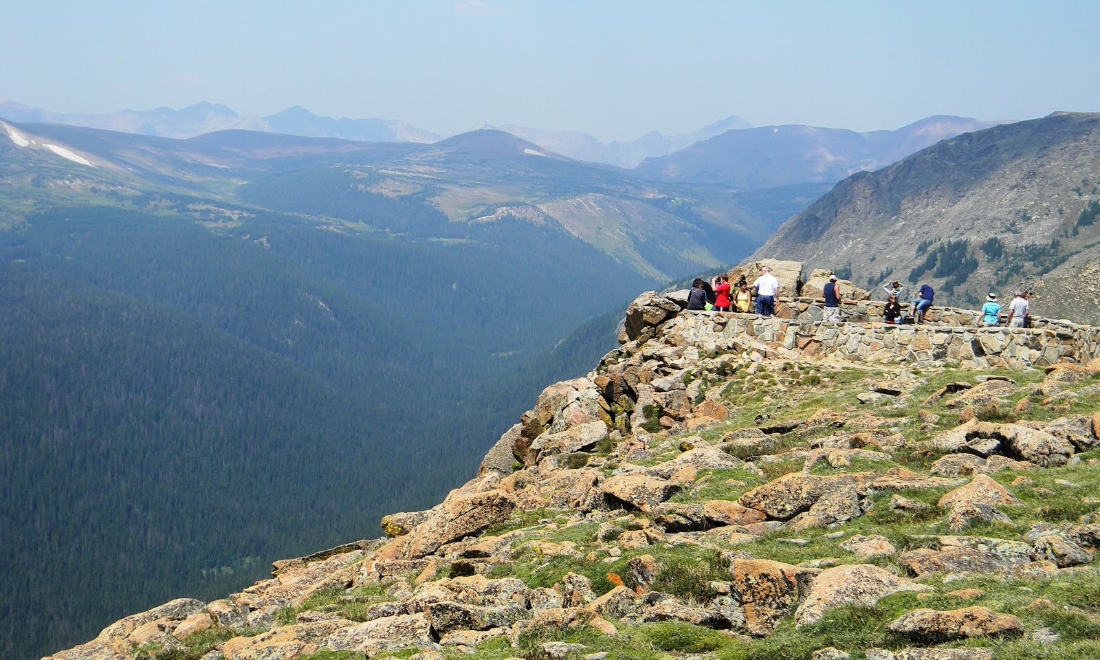
I belayed Terry up and we sailed through the second pitch.  It was less difficult than the first one.  By now the sun had done a good job of drying out the rock and warming our spirits.  Pitch 3 wandered up disconnected cracks to a spacious ledge with a panoramic view of the valley—a view that was so divine, we decided to stay awhile to relish it.  Setting the rack and slings aside, we sat on that lofty perch and shared a granola bar.

It was during this respite when I began to take exceptional note of the clouds swelling up along the Continental Divide.  Fluffy white clouds had been scuttling across the sky all morning, but not of any size to cause alarm.  But now, the thunderheads forming yonder were dark and ugly and slowly coming our way, and I figured we had maybe two hours before they reached us.  The race was on.  I grabbed the rack as Ter put me on belay, and then I was scrambling up the next pitch.  It was easy ground, so I only placed a couple of obligatory Camalots along the way.  When I reached the next belay ledge, I built an anchor and brought Terry up.  Then I quickly started up Pitch 5: a 5.6 hand crack that was considered the crux of the climb.


I was about six feet above the belay ledge, at a stance to place my first piece of protection, when I reached for a sling and discovered that I didn’t have any.  Not one.

“Sweetie, you got the slings?” I asked.

“No. You have them.”

“No, dear, I’m telling you, I don’t have ‘em.”

“Well then, where are they?”

That’s when it hit me: I must’ve left them sitting on that big, gorgeous ledge with the panoramic view of the valley—the very ledge that was now 150 feet below us.  And not only was it the slings that I’d forgotten, but half of the spare carabiners!

I’ll admit it: I dropped the F bomb here.  Maybe two. (My wife will tell you that I was cursing like a drunken sailor, but who are you going to believe?)  I was pretty sure we could’ve squeaked by and finished the climb without the slings and extra ‘biners.  But leaving gear behind doesn’t come easy for me, except when it’s absolutely necessary. (Ask any climber: this stuff is not cheap.)  For this reason—that, and feeling like an idiot for forgetting gear—I down-climbed back to Terry and fixed the rope for a single-line rappel.  Then I rapped down to the prior belay ledge, and sure enough, there they were: right where I’d set them.  Quickly, I snatched them up and speed-climbed back as fast as I could, huffing and gasping the entire way.  Bleak storm clouds were now directly overhead, shutting out the sun.  I could smell the rain on the breeze.  It was coming.

Back on lead for Pitch 5, I jammed up the hand crack, plugging in gear, keeping it moving with a close eye on the sky.  Thunder rumbled in the distance, but the rain was holding.  I was almost out of rope when I reached a broad shelf with a twisted, lightning-scorched pine tree (a bad omen?).  I used the gnarled trunk for an anchor and belayed Terry up.  Far away, there was more thunder.  The summit was close at hand: just one pitch of easy climbing remained.  However, from what I had culled from the guidebook back at camp, we could now escape to the right, following a series of precarious but easy ledges to the back of the crag, and from there, descend a short, 3rd Class chimney to the ground.  With a storm bearing down and all the best pitches behind us, this seemed like the prudent option.  Much of the way was marked with small cairns (there were some big drop-offs if you were to go the wrong way), and before long, we were scrambling down the 3rd Class chimney to the forest floor.

We were trucking down the descent trail when the heavens opened up, first with hail and then rain.  Thunder crashed like artillery.  We donned our parkas and continued down the path, past an abandoned mine from a bygone era, down to the highway and back to the van.  By the time we reached the road, the rain had stopped and the sun was breaking out—at least for the moment.

Back at camp, we relaxed in the van for the remainder of the afternoon; reading books; listening to summer showers come and go until nightfall.  It was pasta and salad for dinner.  Then we turned in early, rain still tapping random patterns on the roof.  This is when one can reflect on the day, and the words of John Muir came to mind:

“Climb the mountains and get their good tidings. Nature's peace will flow into you as sunshine flows into trees. The winds will blow their own freshness into you, and the storms their energy, while cares will drop away like the leaves of Autumn.”


7-  HIGH IN LEADVILLE


In 1882, the Tabor Opera House in Leadville hosted a lecture by the famous Irish playwright, Oscar Wilde, one of many celebrities who visited this bustling Silver Boom town, the second largest town in Colorado at the time, after Denver.  Wilde later recounted his visit to one of the many saloons along Harrison Avenue, recalling a sign on the piano which read: “Please do not shoot the pianist. He is doing his best.”  Not long after, at the Silver Dollar Saloon across the street from the Tabor, Doc Holliday shot a man over a five dollar gambling dispute.

Those were indeed Wild West days, but Leadville has changed considerably since then.  For starters, population-wise, it’s now only a fraction the size of its heyday when all the mines were running full tilt.  At an elevation of 10,200 feet, it’s the highest incorporated city in the country, erected in a sage-covered valley near the headwaters of the Arkansas River, circled by divine peaks, one of them a 14’er named Mt. Elbert.


It was about noon when we arrived in town.  Inclement weather, or the pending threat of it, had dampened our aspirations for climbing on Monitor Rock for a second day, so we broke camp and hit the road.  Our first stop was the municipal water district office on the outskirts of town, where three dollars bought you potable water from a spigot attached to an old hand pump, similar to the pump Ma Ingalls used at the well in Little House On The Prairie.  You could pump until your tank was full or your arm fell off, whichever came first.

Pumping your own water (15 gallons worth) works up an appetite, so our next stop was downtown to find a place to eat.  We settled on the Golden Burro Café, which was next door to the Yellow Ass Saloon.  Terry had a tuna melt, while I went for the Ruben.  Then we split a piece of homemade pie for dessert.  The food was scrumptious, the service was extra friendly.  In fact, all the people in this town were unconditionally gracious and laid back.  After lunch, we strolled down Harrison Avenue, shop to shop, in and out of rain showers.  There were shops selling antiques; eclectic books; souvenirs; mountain bikes; backcountry skis; fishing tackle.  There was the Melanzana store, where you can walk in and literally buy their quality fleece clothes as they roll off the sewing machine.  In this respect, Leadville is the anti-Aspen, or at least resembles what Aspen must’ve been like in the 1960s before all the money moved into town.  The middle class works and lives full time in Leadville, and tend to embrace the rugged outdoors and are fiercely independent.

Ironically, the town can appear high in more ways than just elevation.  I passed by a marijuana dispensary shop on a side street, and this piqued my interest.  I whipped out my i-Phone and did some Googling (you gotta love 21st century technology).  Lo and behold, there are THREE pot stores here!  I found this quite intriguing, since Wikipedia reported the town’s population at 2,600, with 69 percent of them in the 18-60 age range, which calculated out to 598 potential customers per shop.  While it is unknown how many of those potential customers have health issues warranting a doctor’s prescription for a bong load, rest assured the ones in need are well taken care of.

The Great Outdoors is a big deal in this town, from fly fishing on the Arkansas River, to cycling over alpine passes.  For such a small community, there were a lot of bicycles, and the locals seemed to ride them everywhere: to work; school; the grocery store; the pot dispensary...  Come winter, there’s the annual skijoring competition (an old, Norwegian sport where skiers are pulled by dog teams or horses).  But the “Big Event” of the year is the Leadville 100, and it was just one week away.  We ducked into the race headquarters during a hailstorm and browsed through the T-shirts and souvenirs.  A slew of event organizers were hustling about, setting up tables and unloading boxes from a delivery truck.  This hardcore mountain bike race attracts over a thousand competitors, including the best pro riders.  It’s 100 miles of high-altitude riding, mostly singletrack and jeep roads, with a total elevation gain of 14,000 feet.  And if that’s not grueling enough, there’s the 100-mile trail run, which is held the day after the bike race.  Many of the entrants are Ironman ultra-marathoners, and they will compete in both races, back to back.


Late afternoon, the rains relented to a low, slate-grey sky.  We stopped at a grocery store on our way out of town to pick up a few more days of food.  As we were entering, a young couple on mountain bikes rolled up and parked at the bike rack near the door.  Both of them wore rain parkas and had scruffy dreadlocks and nose piercings, and they also looked in damn good shape.  The girl pulled a couple of canvas grocery bags out of her daypack and they followed us into the store.  That’s another thing: Ter and I were the only customers in the store who didn’t bring their own bags.  We stood out like a sore thumb at the checkout stand.  I felt like I should’ve been wearing a sign: “Please don’t shoot the tourist. He is doing his best.”

Exactly how does one get a marijuana prescription anyway?


8-  DOWNHILL AT THE BRECK


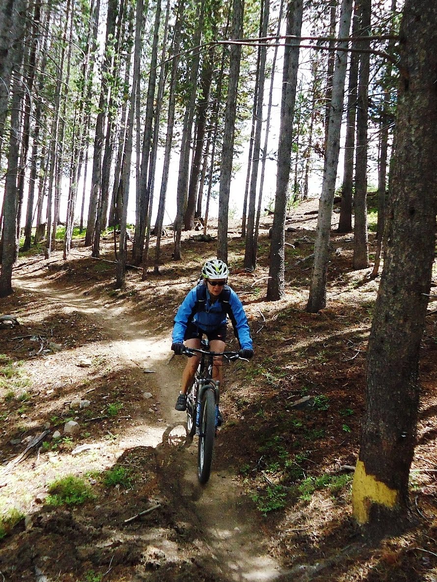
It was one of those immaculate days where everything seems to fall into place as a natural order of things.  We rose early morning to a warm sun and blue skies.  While Terry whipped up some Spanish omelets, I gave the bikes a checkout, and after breakfast, loaded them onto the rack.  We then drove into Breckenridge, up to the ski lodge, where we bought tickets; donned helmets; jumped on the lift; and before long, we were standing on a scenic ridge at 11,300 feet, psyched for the first run.  Then the second run.  Then the third run, and the fourth…

We began the day on the intermediate-level Swinger, discovering right away that the trails at Breckenridge—aka The Breck—contrasted from those at Snowmass.  Where the slopes of Snowmass were mostly loamy earth, making for smooth, fast trails, Breckenridge was comprised of brittle shale, spawning bone-jarring sections of trail that had our bikes’ suspension systems earning their keep.  Some of the rocks were deceptively loose, poised to ruin your day if your tire were to strike it at the wrong angle.  We were streaking down through the woods at one point, my wife leading the way.  I was tucked in right behind her, just twenty feet separating us.  But when we shot across one of those “loose” sections, she kicked up a stone the size of a golf ball, and it spun back and struck my helmet with a resounding smack, narrowly missing my face.  I didn’t tailgate her after that.

After five runs down the mountain, we stopped at the lodge at the bottom for a bite to eat.  The plaza was hopping with both tourists and cyclists.  Kids were darting through the crowd, cotton candy and balloons in hand.  A blues band was playing a Steve Miller tune, adding to the festive mood, all of this to a backdrop of emerald mountains and sunny skies.  Business-wise, The Breck appeared to be having a prosperous summer.  And with its close proximity to Denver—just 80 miles away—it probably does just as well during the ski season.

The actual town of Breckenridge was also very cool: a bustling hamlet with quaint shops, sidewalk cafés, and an excellent bakery that was out of this world (darn, I can’t remember the name of the place).  Another cool thing about Breckenridge is that it’s likely the most bicycle-friendly town in the country.  I’ve never seen so many bike paths and lanes—which may go to prove that if you build the bikeways, riders will come.

Meanwhile, back on the mountain, we were wrapping up lunch when a couple of gents in dusty riding duds asked if they could have our table when we left.  They looked to be in their late 30s, early 40s.  One was lean and quiet, while the other was burly and vociferous.  I chatted with them while Terry went to the bathroom.  They were from Austin, Texas, and the boisterous one swanked that he’d been to The Breck a few times before, and that it was one of his favorite places to go downhilling.

“It’s stellar man,” he declared.  Then he asked if we had gone down Dwight’s yet.  Dwight’s is a black diamond run, and when I conveyed that we hadn’t, he gushed: “You gotta ride it, man!  It’s awesome!  Best trail here.”

When Terry returned, we said our goodbyes to the Texans and headed over to the lift.  But just as we were queuing up to hand our bikes off to the lift operator, Terry sounded the alarm, pointing to my Camelback and crying: “Hey, hey!”

Somehow, the bite valve at the end of my bladder’s drinking tube had been ripped off, and water was squirting out in a steady stream, onto the ground, my bike, even hapless people walking by.  I quickly shut the finger valve, but by then, the bladder had pretty much been emptied.  We searched the ground for the bite valve, but alas, it was gone and lost forever, no doubt inadvertently yanked from the tube back at the lunch table.


After a post-lunch sortie down Pioneer to get the juices flowing and the confidence glowing, we elected to give Dwight’s a try.  Akin to the other trails, it was loose and rocky in places—only steeper.  We careened down through lodgepole and spruce, and in due course avoided the most gnarly section by escaping onto Breakaway.  It was daunting work—so daunting, in fact, that we gravitated back to the mellower Pioneer and Swinger for the remainder of the afternoon.  In all, we logged 27 miles for the day, descending 10,400 feet.

Back down at the lodge, we snagged an empty table outdoors and ordered up a couple of pale ales.  The band was still laying down a wicked groove at the far end of the patio, and all the tables were packed and kids were dancing about.  In fact, sitting at the table right next to us, were the two guys from Austin!  Only Mr. Vociferous didn’t look so well.  He looked as if somebody had beaten him with a baseball bat, slouched over with his elbows propped on the table, a handful of ice cubes pressed to his face.  Angry red scrapes were etched across his right cheek, from jaw to the temple, and his lips were swollen and bloodied.  His right leg and arm were also cut up, as if he’d been dragged across a giant cheese grater.

To hear the poor fellow tell it, he had been barreling down Dwight’s when he suddenly decided to take an “alternate” chute, and things went downhill—no pun intended—soon after that.  He catapulted over the handlebars into a face plant, and then tumbled down the slope a bit before coming to rest.  Miraculously, he didn’t break anything.  In fact, he was in surprisingly good cheer—or going into shock.  When he hobbled off to use the men’s room, obviously in pain, Terry suggested to his friend that maybe he should take him to the ER to see a doctor.

“Just in case,” she told him.

The man smiled, and replied: “I’m an ER doctor.”

So there you go.  Back at our campsite on Dillon Lake, nine miles north of town, we sat outside the van in our camp chairs with a glass of Shiraz, treasuring the sunset; Neil Young’s Harvest Moon on the stereo; the planet slowly rotating on its axis.  As the day withdrew on the horizon, one thing was assured: another one lay ahead.


TO BE CONTINUED...