Thursday, May 1, 2014

On the Trail in Sedona


It was Terry’s spring break, and after visiting my mom and step-dad in Mohave Valley, Arizona, we swung over to Sedona to indulge in some riding. I hadn’t been to Sedona in twenty-two years. Back then, the tony desert enclave was known for its Southwest art, energy vortexes and ancient Anasazi ruins cleaved into ruby cliffs. There was also good rock climbing (home of The Mace, a classic ascent of a 300-foot tower). All of this is still there today, but what’s new is that Sedona has become the next Mecca for mountain biking—or at least that seems to be the word on the blogs and from riders who have been there. It was worth investigating. Besides, we were past due for a road trip anyway.


We hiked the Munds Mountain Trail in its late day splendor. After four hours of driving, it was invigorating to get out and stretch our legs. The desert was cool and serene, deep shadows etching the bluffs and valley floor while the steep ramparts of Mount Wilson still basked in the sun. The surreal backdrop recalled Castaneda’s Journey to Ixtlan, and any moment I expected the shaman Don Juan himself to amble up the path with his all-knowing glower. We paused and relished the moment. One never tires of watching a desert sunset.


Our first night, we dined at El Rincon in the Tlaquepaque Plaza, where Flamenco guitars and Spanish love ballads further enriched the ambience. Over margaritas and dinner, we discussed our itinerary—after all, we had come to Sedona to do some biking, had we not? Terry asked: "What trails do you have in mind?” Well, trails that don’t land me in the emergency room (again) would be a good start.


Conflicting emotions flared in the morning as we geared up to ride. On the one hand (no pun intended), I was apprehensive with getting back in the saddle just seven weeks after my carpal tunnel surgery. But on the other hand, I was biting at the bit to get on the trail with my new bike. I had ordered up a Trek Fuel EX9 29’er, and Doug built it and brought it home just days before we were to depart. I was stoked. But I was also worried about crashing and re-injuring my hand. It was classic yin-yang.


The Big Park Loop trail network was first up in the morning. It was rated “easy,” and having not been on a bike in two months, that was quite okay with me. However, there were loose baby heads galore in sections, which served to be counterproductive to building confidence. This was considered an easy trail? Really? Even more disconcerting, there are scant few “easy” trails in Sedona, so at some point, we’d have to move on to the harder stuff. Nevertheless, my sweetheart was as spry as a jackrabbit through the rocky parts. For me, it took a while. The second mile felt easier than the first, and the third mile felt easier than the second… Slowly it was coming back.


It is said that the portal to one of Sedona’s four geomagnetic vortexes is located on Bell Rock, where seekers clamber up the sandstone monolith to embrace the energy that surges out of Mother Earth like an invisible cyclone. The trunks and limbs of nearby juniper trees have a spiral twist to them, suggesting that something’s going on here. Some folks contend you can feel the “rush” well before you reach the bell-shaped rock. We certainly felt a rush on the approach. But I think ours was caused by the daunting cactus garden we were compelled to ride through, where needle-sharp spines were poised to pierce both tire and hide at your first mistake.


The Llama Trail was our introduction to Sedona's intermediate-level terrain. It had it all: Twisty turns; fast-flowing singletrack; rock slabs; technical drops and climbs—and a breathtaking photo op around every bend.


In my head, I repeated the mantra again and again: “See the line, BE the line.”


I was barreling down the trail when I came upon a big drop of jumbled slabs, and a klaxon went off in my head and I choked and slammed on the brakes. No way, man.

Ter rolled up beside me, stopped and peered over the drop. “Go for it,” I told her. “I’ll get a photo.”

She fell for it.

Backing up a ways to get a rolling start, she charged down the drop, totally nailing it, and rocketed down the trail, disappearing into the trees. “No problem,” I heard her call out in the distance.

Damn it. Now I had to do it.

See the line, be the line.

I was elated when I shot through the gauntlet unscathed. Then again, there were bigger drops to come.


So we're riding along this big slab shelf on Llama Trail, Ter leading the way, and next thing I know, she's leading us up a dry creek bed into a juniper forest, and the trail is becoming narrower by the minute. What the heck? Dear, are we off route? She stops, shrugs, and points to a rock cairn and tire tracks in the dirt. Okay. So we forge on. But fairly soon the track disintegrates into a boulder-strewn sand trap about three feet wide with overhanging brush. Clearly we are up the proverbial creek on this one.

Sure enough, returning to the big slab shelf, we immediately see where the actual trail takes a sharp turn and traverses westward. In fact, the trail map we had snagged at the local bike shop made a note of it: "Trail makes sharp left turn at rock slabs."

That’s right folks, when all else fails, read your topo map.


Livin’ it up on the Llama Trail.


We watched the sunset from a rooftop table at Oaxaca’s in downtown Sedona, tipping back margaritas and winding down the day. My left hand ached from the riding, but tequila and ibuprofen solved the problem soon enough. Life was good.


In the morning, the grind up Cockscomb was warm. Hot, really. We took an extended break in the shade of a juniper halfway up the grade, quenching our thirst with more water. Silence and beauty pervaded the red-rock country around us. At times like this, the rest stops are the best part of the ride.

Further along, we met two women hiking down the trail. They were looking for the vortex that was supposed to be in the area, and asked if we had seen it. Nope, we assured them, we hadn’t. They thanked us and continued on. We headed down another trail, but it got me to thinking: What does a vortex portal look like anyway?


Durango Bob, our affable campsite neighbor, had recommended a trail called Aerie, so we decided to give it a whirl. Right out of the gate, we were sucking wind the first mile and a half, steadily climbing the west slopes of Doe Mountain. Had it been negotiable to pedal along in granny gear, it would have been a cruise. But due to the rocky nature of the trail, speed and momentum were your friends, obliging you to use a higher gear and go faster. Uphill.


The highpoint of Aerie is on the north side of Doe Mountain. From here, it was an exhilarating run down fast-flowing switchbacks.


Hurtling around the bend, I felt a distinct surge of energy and vertigo, and was awestruck by what I saw before us: The trail ran straight into a vortex! Now what? Was it safe? Would we be transported to another dimension where we’d never have to pay income taxes again? Would we find the missing Malaysia Airlines plane on the other side? There was only one way to know. So we pedaled on.


The last blast of the trip was a high-speed romp down Cockscomb and Dawa. Just how fast do you wanna go?


The sun was setting when we got back to town: our third Sedona sunset. The margaritas and food at the Barking Frog were out of this world, the best yet. Pulling into our campground, we parked under a canopy of big sycamores beside Oak Creek and settled in for the night. In the morning we would start home. With all the amazing trails here, we had merely scratched the surface. Which meant only one thing: We’ll be back.

~~~~~~~~~~~~~~~~~~~~~~~~~~~~~~~~~~~~~~~~~~~


Trails we rode:

BIG PARK LOOP – Darn challenging for an “easy” trail.
PHONE TRAIL – Easy and mundane.
LLAMA TRAIL – Terrific drops in a magnificent setting.
ARIZONA CYPRESS – A cruise along a dry, shady creek.
COCKSCOMB – Fast fun on the downhill.
AERIE – Technical uphill w/ fast-flowing downhill (keep an eye out for the vortex).
DAWA – Similar to Cockscomb.


Places we dined while searching for the perfect Margarita: 

EL RINCON – Good margaritas; excellent food; amorous atmosphere with live Flamenco music. Ole! 

OAXACA – Okay margaritas; so-so food; outstanding view of the sunset from rooftop dining area. 

THE BARKING FROG – The best margaritas; excellent food (try the cactus fries). One of the waiters had a cast on his arm: broke it while mountain-biking. My kind of place.

For more Photos:

Go here to see the whole slide deck (25 images)...
https://www.flickr.com/photos/91696789@N00/sets/72157644498396403/


Tuesday, April 8, 2014

The Art of Falling


I was sitting in the lobby area of the Kaiser Permanente lab department, listening for my name to be called. The room was brimming with people who were waiting to be summoned, so I had no choice but to be patient (not one of my strong suits). A blood sample was what I was there to give. That, and have them wire me up for an electrocardiogram. Standard procedure, I was told. It had to be done before my “operation.”

I had already paid a visit to my surgeon earlier that morning, where he walked me through the procedure that was going to be done on my left hand in about a week. A one-inch incision would be made at the wrist, followed by some intricate cutting of the carpal ligament. This, he explained, would enlarge the space in the carpal tunnel and relieve pressure on the median nerve. The surgery would take less than an hour. I would be home by mid afternoon.

What can I say? I have been on and off the injury wagon close to twelve months now. Sciatica flare-ups and a strained lumbar had been the initial culprits. But I weathered through those episodes and kept at the climbing and mountain biking whenever physically able. Ibuprofen was my friend: my prime defender against the creep of age. After all, you don't stop following your passion because you grow old—you grow old because you stopped following your passion.  

However the Battle of Aches & Pains took a turn for the worse last July when I pulled that endo in Big Bear on my mountain bike. I had lost the line down a dubious stretch of black diamond trail; bashed into a hefty rock with my front wheel; sailed over the handlebars. I’ve done this before, it’s no big deal. Just roll with it. But this time it was an awkward fall and I landed head first, both hands taking the brunt of the impact. Two sprained wrists and a fractured left hand was the consequence of me losing that divine line.

Eight weeks of healing and rehab followed. The fifth metacarpal bone in my left hand mended nicely. But there was lingering numbness in my thumb, index and middle fingers, likely due to tissue inflammation caused by the sprain, which was now pressing against the median nerve in the carpal tunnel. My hand doctor gave it another five months to see if things would improve. They didn’t. And that’s how I found myself sitting in the Kaiser lab department, waiting for them to call my name so they could poke me with needles and even conduct an EKG to test my ol’ ticker because, after all, I’m getting up there in dog years. The things you gotta go through to have surgery these days.

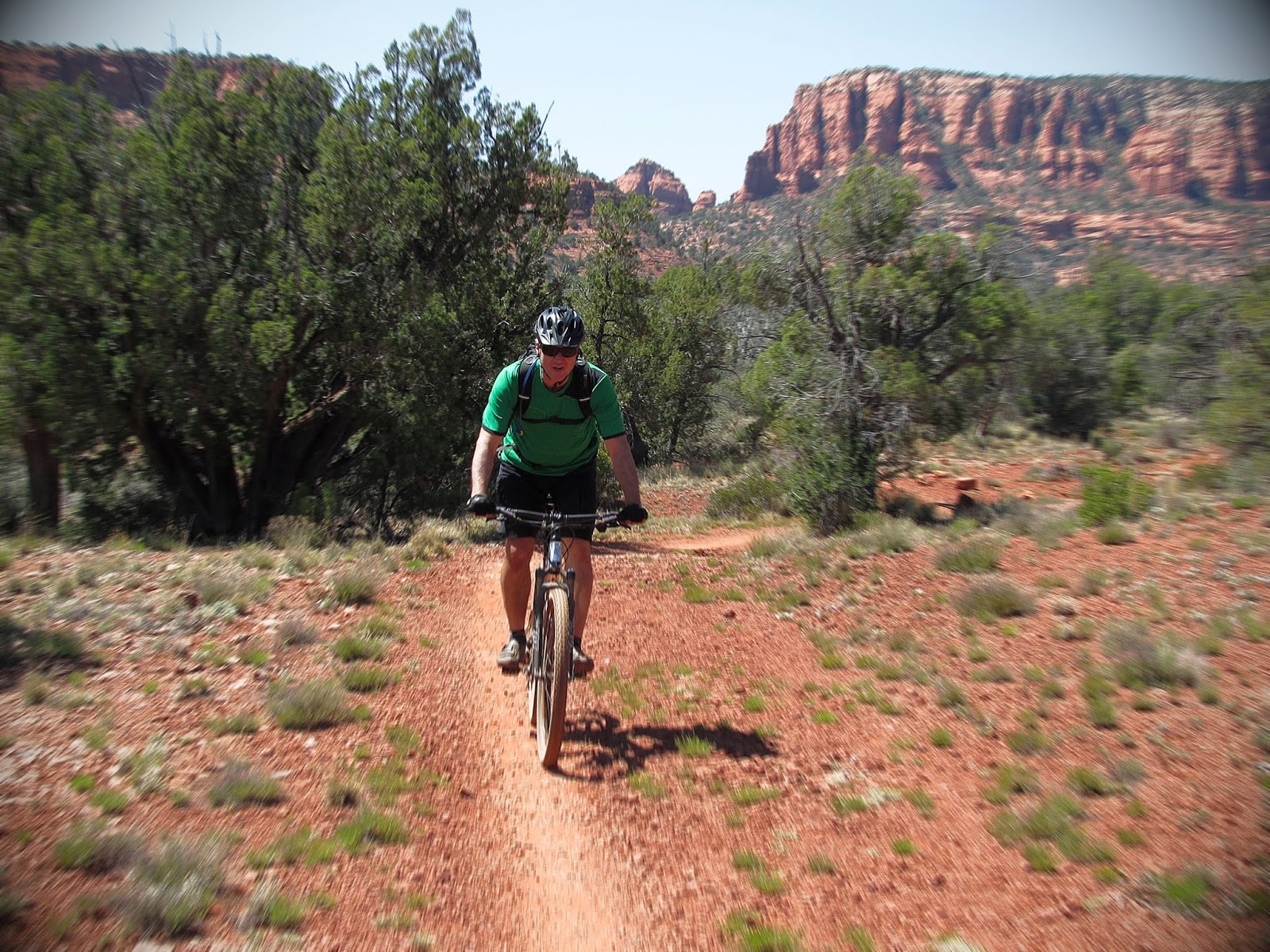
It was afternoon by the time I got back to the house. It was a sunny February day. Since Terry was still at school, I decided to take my trusty StumpJumper into the Chino Hills for a solo ride—besides, I was scheduled for surgery in a few days and would soon be out of action for eight to ten weeks. I loaded my bike onto the rack; jumped in the car and motored up to the Rim Crest trailhead. Since there wasn’t much daylight remaining, I opted for a short but vigorous eight-mile loop that would take me up Telegraph Canyon, returning via South Ridge.  

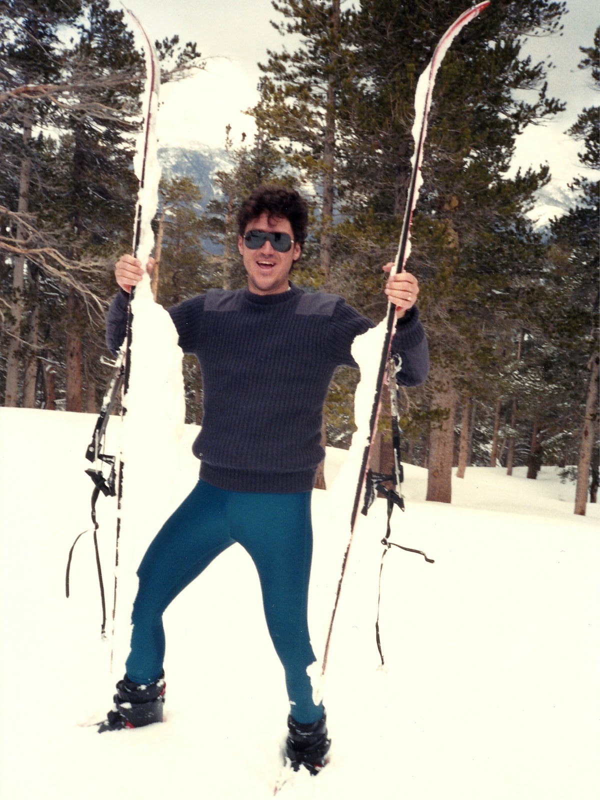
I didn’t pick up mountain biking until I started dating Terry. She got me into it. I blame her. But I have to admit, it is the closest thing I’ve found to my randonnee ski days, imparting untainted bliss once you get into the Zone. Each year, my riding would improve. Now I can give my wife some bona fide competition on the downhill shreds—though she still dusts me on the uphill grinds.  

I pedaled through the trailhead gate and bounded down the singletrack that dropped into Telegraph Canyon. At the bottom, I picked up the dirt service road and followed it up-canyon for three miles, then turned south onto the Bovinian Delight singletrack, the technical crux of the ride. It climbs into Tarantula Canyon through grasslands and stands of live oak, becoming more rugged as one ascends. Ter and I had ridden it two weeks prior, so I knew there were some eroded and gnarled sections. Vigilantly I navigated through them, nailing the banked hairpins with a sense of purpose. Yes! I was in the Zone now.

The last sweep of Bovinian traverses a steep hillside to South Ridge, and to get across it, I had to negotiate one final chewed-up section of trail. I gained momentum as I approached the bumps, choosing my line judiciously. But things happen quickly when tackling the rough. My front tire tapped a rock, knocking me out of the line; I corrected; hit a rut and lost the line again; struggled to regain it, and then THUD—my front wheel smacked another rock head-on and came to a stop. From there, the laws of physics took charge and catapulted me over the handlebars.

Unlike the crash last summer, I was able to tuck into a somersault instead of landing face first. Not to say it wasn’t a hard landing. I lay there on my back for a minute, stunned and humbled, thinking: Maybe I’m getting too old for this shit. Then I slowly stood up, dusted myself off, extracted my bike from the scrub brush and got back in the saddle.

Quick work was made of the last three miles, shredding the fire road that undulated down the spine of South Ridge. I was back to the car before sunset. Terry was at home when I got there, and she soon noticed the scrape on my elbow. It was nothing, I told her: just took a little spill. After stowing my bike and gear away, I headed upstairs to clean up. A hot shower would feel good on my lower back, which I had to admit, was now quite sore from the fall, and while waiting for the water to heat up, I went to the bathroom. That’s when I got the big shock: I was urinating what looked to be pure blood.

This couldn’t be sunny news, I figured. After a hasty shower, I threw on some clothes, contemplating how I was going to tell my wife—or maybe not mention it at all—when she came into the bedroom. I must have had a dreadful guise to my manner (or maybe she really is clairvoyant), because she immediately asked me what was wrong.

With the most blasé expression I could muster, I explained that I just might, maybe, have to go to the ER. And of course she wanted more details—a lot more details.

“I feel fine,” I told her. Other than my back being a little tweaked from the fall, this was true. I had obviously bruised my left kidney, but maybe I should wait to see if the bleeding cleared up on its own; just give it a few hours before rushing down to the emergency room.

She wasn’t buying it.

Soon after I checked into the Kaiser Hospital ER, an attendant ushered us back to a private bay where I could lay and watch the Winter Olympics on TV while Ter sat and graded quizzes and homework (I’m telling you, she lugs that tote bag of papers everywhere). A nurse instructed me to pee into a cup, and then she dropped by later to examine the blood-red specimen, holding it up to the light.

“That doesn’t look good,” she quipped.

Then she started asking me a slew of questions: What happened? Do I feel pain anywhere? Dizziness? She was standing at the computer terminal as she was grilling me, queuing up my medical records.

“Wait a minute,” she said. “You were here earlier today?”

Yep.

“For pre-surgery lab work and consultation with Dr. Harness?”

Yep.

“You’re scheduled for hand surgery next week… for an injury incurred while mountain-biking?”

Yep.

“But it says you’re here tonight because you were injured mountain biking… is this a SECOND accident?”

With a raised eyebrow, Ter looked up from her paper-grading and responded with an irony-coated “Hmmm.”

Later, a doctor showed up; scrutinized my chart and said: “Fell off your bike, eh?”

I provided an abbreviated account of my endo in Chino Hills, to which he then asked what trail I’d been riding. I told him Bovinian Delight.

“Yeah, I’m familiar with that trail,” he replied. Turned out, he was a mountain biker! Doc and I then talked bikes. Terry rolled her eyes and went back to her grading.

A melancholy funk seeped in after the doctor left. While I waited for the results from my CAT scan, I watched Shaun White choke on his bid for the gold in Sochi. His fall from the top of the snowboarding hierarchy was nothing but gracious. I took note of this. Like my mountaineering mentor, Bernie McIIvoy, once said to me years ago: “One must find the path to grow old gracefully.” And as I lay there waiting for my test results, I had to face the music. I had lost the mojo for skiing years ago. My rock climbing is woefully subpar these days. And now I can’t even stay upright on my bike. Maybe I should grow up: act my age and take up stamp collecting. You’re over the hill, dude. This is as good as it gets. Spend your remaining time with the grandkids—while you can still walk.  

It was after midnight before I was finally released. The CAT scan had revealed no internal bleeding, and subsequent urine samples had shown just traces of blood. The ER doctor surmised that my left kidney had taken a hit when I fell, and that I needed to take it easy for a few days. No running, no biking, no heavy lifting... I asked for the restrictions to include no doing laundry or taking out the trash, but was denied.

So maybe this is the end of my riding days. Who knows? Nothing demolishes your passion for a sport more than repeated injuries. Years ago, when I was pushing hard to master the black diamond ski runs, the mantra had been: “If you’re not falling, you’re not learning.” Unfortunately, the same holds true for mountain biking. Falling is part of the game. But so is aging—and like falling, I’m beginning to see that there’s an art to it.

.................................................................................................................................
(The author underwent hand surgery nine days later. It will take eight to ten weeks to know the full success of the operation. In the meantime, he has been spotted at a Trek dealer, specking out the new Fuel EX 29’er.)


Friday, March 7, 2014

Backcountry Skiing - Part 5


T H E   S I E R R A   H I G H   R O U T E


It had been on my tick list since 1979, soon after Bernie McIllvoy and I had skinned up to the Tablelands in Sequoia National Park and spotted those faint ski tracks trailing east, deeper into the Sierras.  I was fairly sure we had stumbled upon the High Route, from what I could cull from Dave Beck’s guidebook to ski touring in the Sierra Nevada.  Beck had pioneered it in the mid 1970s, and as word spread and others flocked to ski the passage, its reputation became renowned.  And for good reason: Fifty miles of backcountry adventure—two-thirds of that distance above timberline—crossing nine alpine passes, six of them 12,000 feet or higher in elevation.  Even today, it is still the most coveted trans-Sierra ski tour.  

I was somewhat a newbie skier when I came across the route that spring day in the Tablelands, and seeing firsthand its rugged and lofty trajectory, I realized it was out of my league.  This was something you had to work up to.  Years passed.  My skills improved.  But it wasn’t until the winter of ’95 before I truly recouped the interest to do it.  And that led to other big challenges: finding partners and working out the logistics.  The start and finish of the High Route are on opposite sides of a formidable mountain range.  Transportation and shuttling become a major undertaking.  And as for finding partners: in the end, it was just me, myself and I.  That’s when I grasped that if I really wanted to do this, I needed to consider other options—like a guide service.

I had never been guided up or across anything before.  Never felt that I needed it.  But the High Route was different.  It was all about logistics.  And after some research, I found an outfit that had it wired: Alpine Skills International.  They had guided parties on the route for years, and the secret to their success was impeccable planning.  ASI would take a dozen clients and split them into two groups—an East-West party, and a West-East party—and each would start the route on the same day, but from opposite ends.  Before the start of the trip, each client was matched with a “car swap” partner from the other group.  I was assigned to the East-West party, and on my drive up to Independence, I first diverted to Mojave and swapped cars with a guy on the West-East party.  He drove my car to Sequoia.  I drove his to Independence.  When the two groups met in the middle of the Sierras on the third night of the trip, we exchanged car keys.  My ride home was waiting for me when I got out.  As for my one and only experience with a guide service: it was very good.  In fact, I learned some tricks for ultra-light ski touring.  The guides were wonderful—and diplomatically patient with one obnoxious client (no, it wasn’t me).  We had glorious spring weather the entire way.  Who could ask for more? 


Sierra High Route, 1995:  Day One.  From the Symmes Creek trailhead, it’s a seven-mile slog up to Anvil Camp, an elevation gain of 4,200 feet.  We hauled the skis for most of that distance.  It was a gut-buster, but we got the toughest day of the trip behind us right away.      
__________________________________________________


Sierra High Route, 1995:  Day Two.  In the morning, we had another 2,000 feet of elevation to gain.  Here, ice axes are out for the final stretch up to Shepherd Pass. 
___________________________________________________


Sierra High Route, 1995:  Standing on Shepherd Pass, elevation 12,000 feet.  From here, we donned skis and glided down to the headwaters of the Kern River (in the distant trees behind my head).  We camped there for our second night.  In the morning, we would ski up towards Milestone Peak (rock pinnacle on skyline at far right) and ascend over Milestone Col.        
__________________________________________________


Sierra High Route, 1995:  ASI guide, Jon Shoop, skis down through the trees along the Kern headwaters.  Jon and I were tent mates for four nights and we got along grand.  I learned a heap from him on fast-and-light touring.  The night before we departed, he went through everyone’s packs, vetoing several frivolous articles that added needless weight.  “No frills,” he warned.  Fortunately he didn't find my flask of brandy—and he also had no qualms partaking in libations with me each evening.          
__________________________________________________


Sierra High Route, 1995:  Day Three.  Ice axes come out again for the precipitous traverse over Milestone Col.  At 13,000 feet, this is the highest point on the High Route.        
__________________________________________________


Sierra High Route, 1995:  This is Carl, a doctor from Connecticut, skiing down the big slopes on the other side of Milestone Col.  He traveled the furthest to come on this trip. 
__________________________________________________


Sierra High Route, 1995:  The Kaweahs brood in the clouds during the long run down from Milestone Col.         
__________________________________________________


Sierra High Route, 1995:  Jon and I hang out in front of our abode, soaking up the stunning views of the Kaweah basin.  We rendezvoused here with the West-East party for our third night, exchanging car keys and celebrating together merrily.  It's the midway point of the High Route: about 25 miles to the roadhead in either direction.  In the morning, our group would continue westward, while the others would head east. 
__________________________________________________


Sierra High Route, 1995:  Day Four.  The majestic Kaweahs greet us in the morning as we ski through Colby Pass.  Colby was the first of four 12,000-foot passes that we would cross on this day.          
__________________________________________________


Sierra High Route, 1995:  Jon Shoop at work on a flawless spring day.
__________________________________________________


Sierra High Route, 1995:  The group takes a break atop Triple Divide Pass to strip off climbing skins.  Though most of the day was spent traversing high along the divide, each of the four passes that we crossed offered short but sweet downhill runs.            
__________________________________________________


Sierra High Route, 1995:  Assistant guide, Glen Norris, leads the way into the bowl below Coppermine Pass, our fourth and final 12,000-foot pass of the day.  We then skied across the slopes in the background and camped near the rocky buttress in far right of photo.
__________________________________________________


Sierra High Route, 1995:  Day Five.  Pausing to regroup near Pear Lake Ski Hut.  By now, our packs were light and we were lean, totally acclimatized and descending.  We skied ten miles in the morning to get to Pear Lake, where we dropped our packs and skinned back up into the high bowls for a few rollicking runs.  Then we hoisted our gear and hit the trail again.  Only six miles remained.            
__________________________________________________


Sierra High Route, 1995:  Skiing across “The Hump” above Heather Lake.  From here it’s a five-mile descent through increasingly-dense woods, until suddenly you burst out of the trees and into the Wolverton trailhead parking lot.  Thus is the final opus of the Sierra High Route. 
__________________________________________________


E P I L O G

San Jacinto Peak, 1996:  Michael Katusian and I stand above the North Face, contemplating the inevitable.  

This photo is the last that I have from my backcountry forays.  After the High Route trip, I pretty much stowed my gear away for good.  Occasionally, in big snow years, when the calling was impossible to ignore, I’d brush the cobwebs off my purple Ramer randonnee skis and set out for the local mountains.  I once did solo descents of San Gorgonio and Jepson on a Memorial Day weekend, carving down perfect corn snow.  Nevertheless, you could count on one hand the times that I strapped on the boards.

I sold those old Ramers on Craig’s List in 2008.  They had been sitting neglected in my garage in Redlands for almost a decade, collecting dust and a colony of black widows.  I didn’t get much for them.  The bindings were ancient.  Their true value lay in the memories that I collected while skiing on them… and I got to keep those.
__________________________________________________


Thursday, February 13, 2014

Backcountry Skiing - Part 4


Unlike winters of late, California was blessed with some superlative snowpack in the mid 1990s.  I took advantage of these good years, focusing on my backyard hills: the San Gorgonio Wilderness, where the possibilities for incredible runs seemed endless.  I skied a few secluded lines that probably didn’t see another descent all season.  Sure, there were occasional jaunts to the slopes of San Jacinto or Baldy.  But I would always, inevitably, be drawn back to San G.  The following images were all taken from forays into the San Gorgonio Wilderness during this period.  
__________________________________________________


San Gorgonio Wilderness, 1994:  Another good year in my backyard. This was taken somewhere on my way down from Big Draw.  A storm had rolled through the night before, laying down fresh powder.  I went up solo for the day, and I took this selfie the old-fashioned way: set the camera on my pack; hit the timer; dashed over and got in position before the shutter went off.      
__________________________________________________


Poopout Hill, 1994:  Michael Katusian and J.R. Muratet taking a short break.  By early April, we could usually hike up to South Fork Meadows and make camp.  From there, we'd make daily sorties into the high country until we exhausted the food and brandy (hence the large packs).    
__________________________________________________


Slopes below Little Draw, 1994:  Michael and J.R. skinning their way up into Little Draw.     
__________________________________________________


Big Draw, 1994:  J.R. and Michael at about 11,000 feet, kick-stepping up to the crest of the bowl.      
__________________________________________________


North Face of San Gorgonio Peak, 1994:  Carving a turn that almost got away from me.      
__________________________________________________


South Fork Meadows, 1994:  Happy hour at base camp.       
__________________________________________________


Poopout Hill, 1994:  Best damn skiing in Southern California.  Period.     
__________________________________________________


North Face of San Gorgonio Peak, 1994:  Michael prepares to drop over the cornice.  1... 2... 3...  
__________________________________________________


North Face of San Gorgonio Peak, 1994:   Heaven.       
__________________________________________________


Charlton Peak, 1995:   Michael starts the fun drop into Little Draw.  Jepson Peak in the background.       
__________________________________________________


Trailhead above Barton Flats, 1995:  Back at the car after another superb weekend in the backcountry.      
__________________________________________________


Thursday, March 7, 2013

Backcountry Skiing - Part 3

.
This third installment picks up where I left off with the old ski pics posted last winter.  After scanning this batch, the first thing I noticed was the spontaneity and action in many of the images, something that the first two parts of Backcountry Skiing had lacked for the most part.  This is due to me switching from a bulky Pentax SLR camera to a waterproof Canon 35mm instamatic that was half the size and one-third the weight.  I usually skied with the Pentax stowed in my daypack for the downhill runs, stopping to pull it out to snap a picture.  But with the Canon, I was able to sling it around my neck: just aim and shoot at the right opportunity.  Nothing like catching the fun on film. 
_____________________________________________________


San Gorgonio Wilderness, 1991:  Steve Johnson and Michael Katusian pose for a quick photo at Dollar Lake before the downhill fun begins.
___________________________________________________


San Gorgonio Wilderness, 1991:  This is what I call a serious case of climbing skins icing up. 
___________________________________________________


San Jacinto Peak, 1992:  Summiting San Jac on an immaculate winter day.  San Gorgonio Peak is in the background. 
___________________________________________________


San Jacinto Peak, 1992:  Michael Katusian drops onto the foreboding North Face.     
___________________________________________________


Below Miller Peak, San Jacinto Mtns, 1992:  Not only is Michael a great skier, he has a fabulous sense of humor.
___________________________________________________


Sawtooth Ridge, Sierra Nevada, 1992:  Michael lounges in the sublime below Matterhorn Peak.  I remember this trip well.  We were jetting up 395 on a Friday night in April, amped up for some spring skiing in the High Sierra.  At Brady’s Outpost, we stopped for coffee, and inside we found the locals huddled around the radio.  “They’re rioting in L.A.!” one of them declared.  Earlier that day, a jury had found the policemen who had beat Rodney King to be innocent, and unbeknown to us, all hell had broken loose.  By the time we reached Bridgeport early the next morning, there was a run on ammo at the sporting goods store—Los Angeles was in flames and everyone up there was expecting a full-fledged race war.  That was the tone of things when Michael and I hiked into the backcountry for a few days of skiing, not knowing how events would play out down south.  It was very sureal.    
___________________________________________________


Sawtooth Ridge, Sierra Nevada, 1992:  A lone skier passing through snapped this photo of Michael and me.  He was the only person we saw during our four days in the backcountry.  Michael asked him if L.A. was still burning, and he said: “Yep.”
___________________________________________________


Sawtooth Ridge, Sierra Nevada, 1992:  Carving a good line near Matterhorn Peak. Sierra skiing doesn’t get any better than this.  I took a wild spill near the end of this day.  No problem: I stood up; popped back into my bindings; prepared to continue down… Then I noticed the blood all over the snow.  Turned out, I’d bounced off a rock on the way down, and a sharp corner had sliced my right elbow open cleaner than a scalpel.  Michael the Medic skied over and closed it up with a couple of butterfly clamps, and I was good to go for another two days.  However, when I got home, the wound was looking pretty scary, prompting a trip to the doctor.  It was badly infected. 
___________________________________________________


Sawtooth Ridge, Sierra Nevada, 1992:  Catching some air time.   ______________________________________________________


Sawtooth Ridge, Sierra Nevada, 1992:  Goodnight, Michael.
________________________________________________________


San Jacinto Peak, 1993:  A winter wonderland.  If I recall, this is how I spent Superbowl Sunday.
_____________________________________________________ 


San Jacinto Peak, 1993:  Seve Johnson summiting in a whiteout.
__________________________________________________


Poopout Hill, San Gorgonio Wilderness, 1993:  My daughter Allison was 2½ years old when I took her skiing the first time.  I would ski up the unplowed road to Poopout Hill.  She liked it—though when she got to be a teenager, she took up snowboarding.  Hmm. 
__________________________________________________


Peak 10,400, San Gorgonio Wilderness, 1993:  The San G Wilderness became my backyard playground in the winter, the trailhead just 25 minutes from my house.  I was up there most Saturdays, many times solo, exploring new terrain, the steeper the better.  My favorite “secret place” was Peak 10,400, where the reward was a sustained, 3,000-foot descent through the trees, all the way back down to Horse Meadows.  Because of all the tree coverage and north-facing slopes, the powder always held up in there.  And I never came across old ski tracks of other parties.  It was all mine.
__________________________________________________


Below Charlton Peak, San Gorgonio Wilderness, 1993:  Michael cruises down from Little Draw. ______________________________________________________


Below Peak 10,400, San Gorgonio Wilderness, 1993:  Steve begins the awesome 3,000-foot descent.  So many ski runs, and so little time.
______________________________________________________


TO BE CONTINUED...