We were in full stride now: two days into the trek with Gio back on board, bringing renewed fervor that lifted us all. Four more days remained. And though the mountains ahead might be daunting, we were primed in both heart and mind. Bring it on!
Day 3: Kaiserjäger Trail
We awakened to a rosy dawn, soft light spilling into the room that I shared with Gary and Mary Jo at Rifugio Lagazuoi. Over breakfast, Jörg shared his daily insights with everyone, noting the high chance of afternoon showers. We needed to get moving.
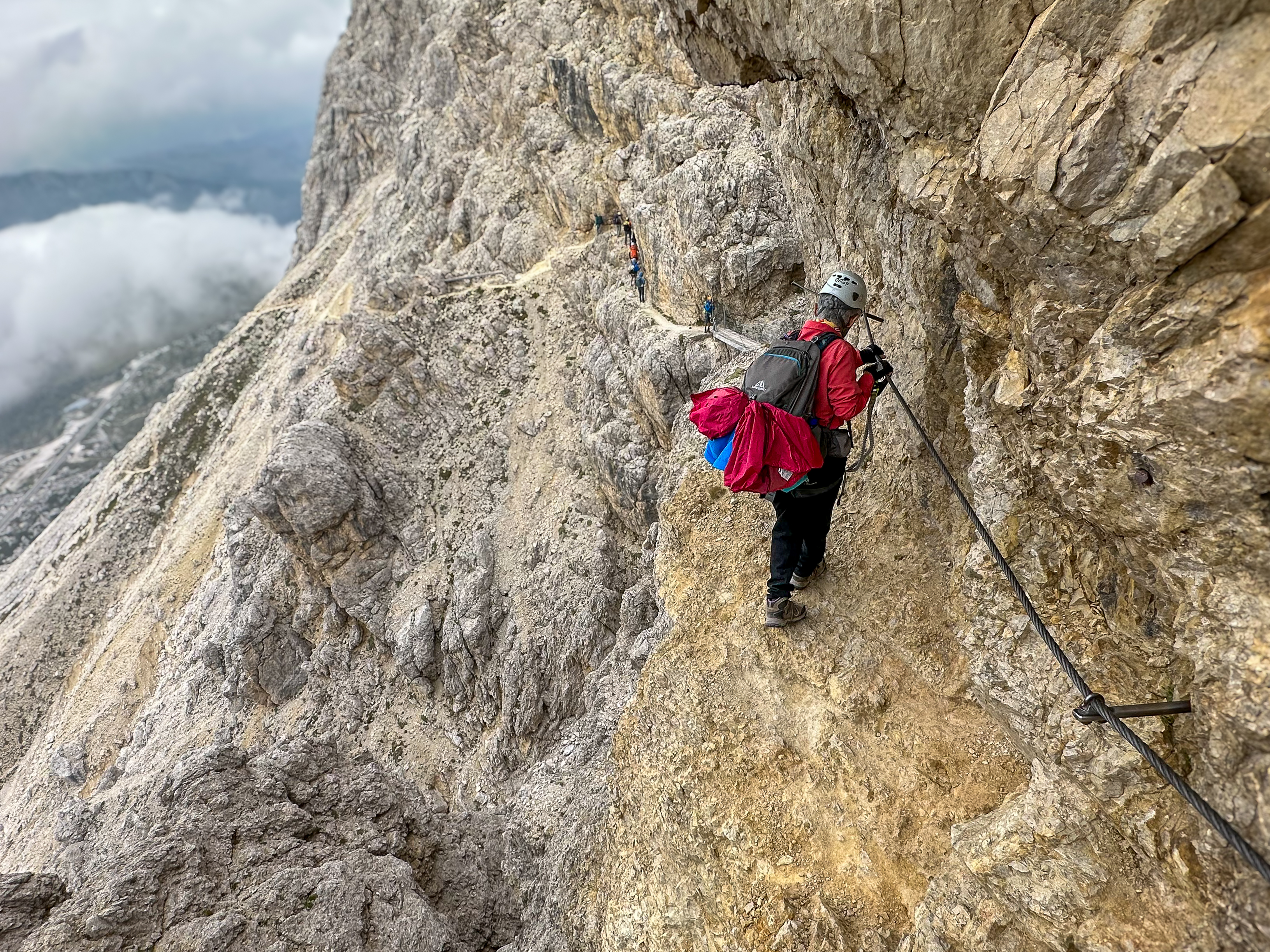
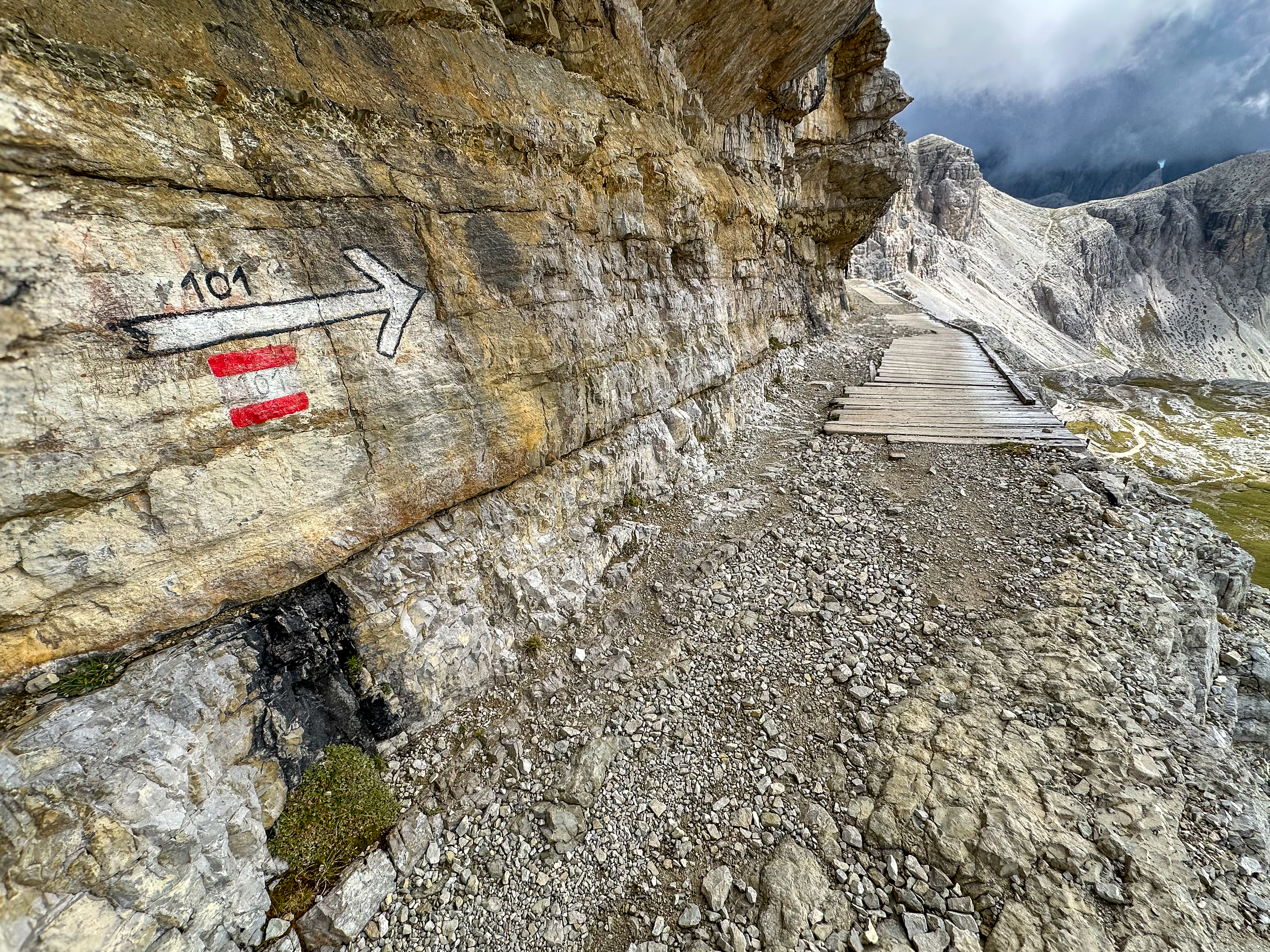
Our morning objective was to descend Mt. Lagazuoi via the Kaiserjäger Trail (A)—a rugged path that zig-zagged down through broken cliff bands to the highway 1,900 feet below. The upper half was peppered with sections of ferrata: cables, ladders, even suspension bridges. While not overly difficult, it was loose in places and slow-going. Ominous dark clouds rolled in as we made our descent; the air growing heavier with each step. We were close to the bottom when the first raindrops began to patter the ground, and with parkas cinched tight we completed the last stretch in a light rain.
Across the road from where the Kaiserjäger ends lies the Forte Tre Sassi Museum, a fascinating place to escape the rain. Originally an Austrian fort, Tre Sassi was abandoned after World War I but has since been refurbished into a museum that tells stories from its military past.
After our museum visit, we shuttled back to Cortina under leaden skies and checked into our rooms at Hotel Panda. The night was ours to explore and I joined Gary and Mary Jo for dinner. I've known them for ages (first climbing trip together was Christmas Tree Pass, 2000). We set off in search of a place to eat, sharing laughs and dodging intermittent showers. The regional beet ravioli at 5 Torri was to die for. All in all, another magical evening in the Dolomites.
 |
| Dawn light on Mt. Marmolada (10,968 ft.), Queen of the Dolomites. |
 |
| Rifugio Lagazuoi |
 |
| Heading down. |
 |
Built in 1915, the Kaiserjäger Trail takes its name from the Austrian regiments
who fought on Mt. Lagazuoi during WW1. Kaiserjäger means “Imperial Hunters.” |
 |
| Our guide, Paul, on a delicate traverse. |
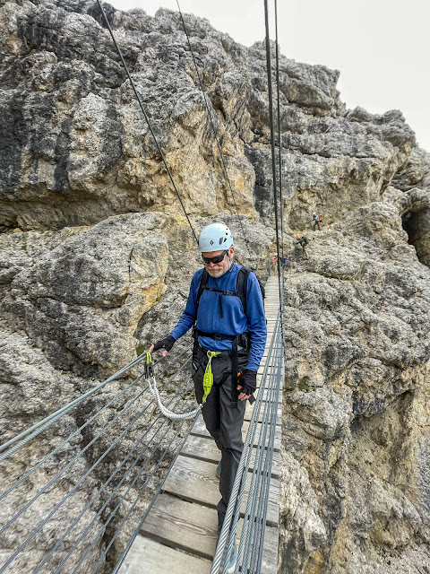 |
Gary crosses one of the suspension bridges that span deep gullies.
(photo by Jörg) |
 |
| Yvonne on the Kaiserjäger Trail. |
 |
| Class in session with Jörg pointing out landmarks. |
 |
Rob and Gio in the rain. We got off the mountain just in time.
(photo by Rob) |
 |
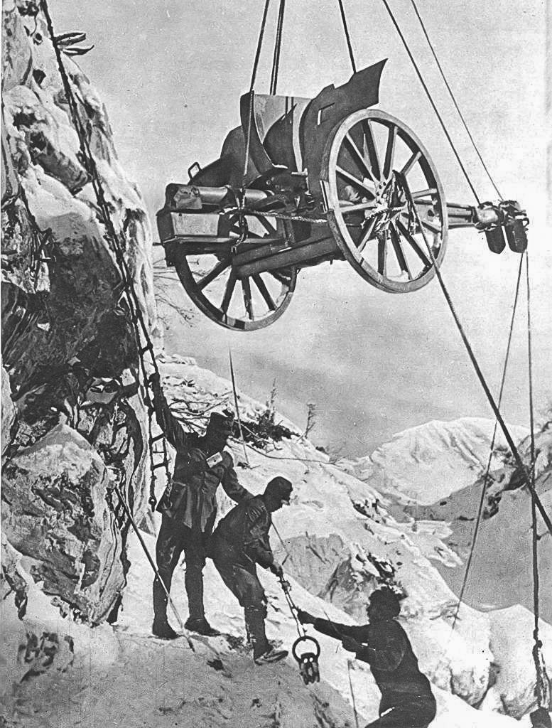
| Forte Tre Sassi Museum. The old fortress was built by the Austrians in the late 19th century on the border between Italy and the Austro-Hungarian Empire. Its operational life was curtailed in 1915 when constant shelling by Italian forces during WW1 rendered it unusable. After the war, the fortress remained in disrepair for nearly a century, standing as a silent witness to a tumultuous history. In 2003, Tre Sassi underwent significant repairs and was transformed into a museum. Today, it houses an impressive collection of World War I artifacts gathered from the surrounding area—a collection project that took 45 years. |
 |
| Great War uniforms on display. |
 |
| Hoisting artillery into position. |
 |
| Moving troops along Via Ferrata routes. |
 |
| Vintage guns & ammo found on the Alpine Front. |
 |
| Vintage shells and ordinance recovered. |
 |
| 1912 Vickers machine gun. A British weapon used by the Italians. |
 |
| Back in Cortina d'Ampezzo. A break in the storm. |
 |
A rainy night.
(photo by Rob) |
Day 4: Ferratas Sentiero Bonacossa & Merlone
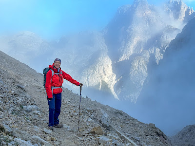
The rain had ceased by morning, leaving behind ragged clouds that clung to the valleys and peaks like a storm’s last breath. Our goal was to reach Rifugio Fonda-Savio by noon via the Ferrata Sentiero Bonacossa (A). Joining us for this leg of the journey was Jörg’s son, Max—an amiable young man and a guide-in-training.
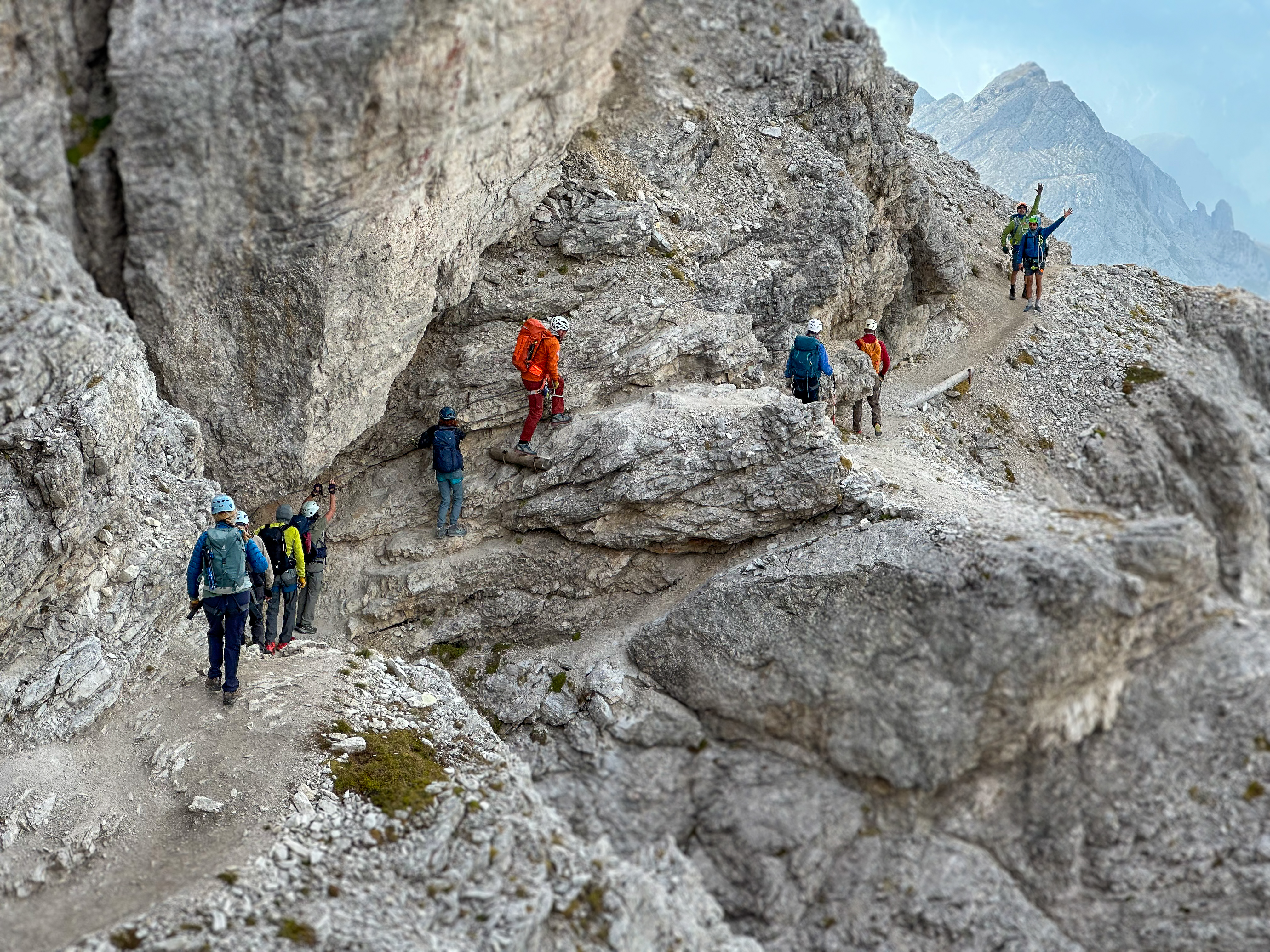
After breakfast at Hotel Panda, we piled into taxi vans and drove deeper into the mountains. We were dropped off at the enormous Rifugio Auronzo (25 private rooms!), where we picked up the Sentiero Bonacossa trail across the road. From there, we hiked along a rocky, undulating ridge that offered spectacular views—though the trail had its ups and downs. Literally. We dropped 600 feet in elevation—including down-climbing a 200-foot chimney—only to trudge back up those same 600 feet to reach Tocci Pass (7,700 ft.) and ultimately Rifugio Fonda-Savio. It was during that last 600-foot ascent where things took a turn for LeRoy: He slipped on some wet rocks, bashed his knee hard, and ended up limping the rest of the way to the rifugio. Once inside, he iced his knee with ice from the kitchen.
The afternoon plan was to climb Ferrata Merlone (B+): a 30-minute approach from the rifugio, then a 900-foot ascent up cables and ladders to the summit. But as I stood on the mountain hut’s deck, pondering the ominous clouds hanging overhead, my gut told me it might be wise to sit this one out. Jörg, however, was all in, his adventurous spirit shining through as he rallied Paul and half of the SCMA Dirty Dozen to join him. They were ready to tackle whatever nature threw their way—and an hour after they departed, it began to rain. As fate would have it, Jörg and his party got hosed off the route and had no choice but to retreat back to the rifugio. It was a classic case of “You win some, you lose some.”
 |
Pam leading the way on Sentiero Bonacossa.
(photo by Jörg) |
 |
Sentiero Bonacossa
(photo by Gio) |
 |
| Nice views along the way. |
 |
Descending to the chimney.
(photo by Jörg) |
 |
Down-climbing chimney.
|
 |
Lorrie and Ben having fun yet.
(photo by Jörg) |
 |
| Storm clouds rolling in. |
 |
Rifugio Fonda-Savio perched on Tocci Pass.
(photo by Rob) |
 |
| Rifugio Fonda-Savio is named in honor of the Fonda-Savio brothers—Piero, Paolo, and Sergio—who lost their lives during World War II. Construction was completed in 1966. There is no road access: all supplies must be hauled up by cable lift. Originally built and operated as a family business, the hut is now maintained by the Italian Alpine Club and accommodates up to 20 guests. |
 |
Margo and Ben having fun on Ferrata Merlone.... in the rain.
(photo by Jörg) |
Gio examines the tiny waterfalls forming on Merlone before the deluge.
(video by Rob)
Meanwhile, back at Rifugio Fonda-Savio... I'm having a beer.
 |
| Obscured by clouds. |
 |
Relaxing after dinner. Clockwise from left: LeRoy, Margo,
Mihaela (hiding), Mary Jo, Gary, Pam, and yours truly. |
 |
| Turning in for the night. |
Day 5: Ferrata De Luca-Innerkofler
The journey was beginning to take its toll. LeRoy’s knee was no better in the morning, and to make matters worse, Gary was feeling under the weather with symptoms eerily similar to what Gio had experienced on the first day. Non va bene! With LeRoy and Gary out of commission, I couldn't help but wonder who else was afflicted in some way. Take me for example: my sciatica was flaring up, a reminder that hiking isn't always as glamorous as it looks in the REI catalog.
We spent the morning hiking down to the Lake Misurina trailhead, where Jörg arranged for a taxi to whisk LeRoy and Gary back to Hotel Panda while the rest of us pressed on, shuttling back up to Rifugio Auronzo where we had started yesterday’s trek. It was noon by then. We scarfed down a quick lunch in the cafeteria, brushing aside misfortunes.
The afternoon objective was to reach Büllelejoch Hütte (8,300 ft.) by happy hour, climbing Ferrata De Luca-Innerkofler (C) along the way. As we gathered, Jörg offered a no-climbing option for those wanting an easier route to the hut. Pam quickly chose that path, and Max was assigned to accompany her. I thought: why not? So, I joined them (and my sciatic nerve would thank me).
What unfolded was a delightful four mile hike up a double-track trail, traversing around the southern slopes of Mt. Paterno (9,000 ft.) and past the storied remains of a WW1 battle. Cows grazed lazily in an alpine meadow, adding idyllic charm to our surroundings. It felt like we had the whole place to ourselves; only the distant clank of cowbells could be heard. We attained Büllelejoch Hütte two hours later. Well over an hour after that, the rest of our group showed up looking weary but triumphant from bagging De Luca-Innerkofler. Happy hour officially began soon after.
As the sun dipped below the horizon, we settled into Büllelejoch Hütte for our last night in the backcountry. The hut was small but felt like home as we filled every nook and cranny with laughter and stories. With only our party for dinner, it created a quieter and more intimate atmosphere than other huts we had visited. We shared memories of our adventures so far, feeling a twinge of sadness knowing this chapter was closing. It was hard not to think about LeRoy and Gary; their absence was palpable. They would have added their unique humor and camaraderie to the night’s festivities. But notwithstanding, I couldn’t help but feel grateful for this experience—both for those who were there and those we wished could join us around the table. All for one, and one for all.
 |
| Rifugio Fonda-Savio in the morning. |
 |
| Jörg and Paul review online weather reports. |
 |
| Hiking down from Rifugio Fonda-Savio. |
THE HIKE TO BÜLLELEJOCH HÜTTE...
 |
Bernese Mountain Dogs on the trail.
|
 |
Hiking past the remains of Austrian WW1 fortifications.
|
 |
| Alpine meadow full of grazing cows (look closely). |
 |
The precarious "road" to Büllelejoch Hütte.
|
 |
| Pam on the Büllelejoch Road. I would stop and walk before I drove this. Scary. |
 |
Pam and me with Büllelejoch Hütte in sight behind us.
(photo by Max)
|
 |
| Located on what was once the boundary between Italy and the old Austro-Hungarian Empire, Büllelejoch Hütte is a quaint refuge that beckons adventurers. It was built in 1960 by Maxwell Innerkofler, the grandson of renowned Tyrolean mountaineer Sepp Innerkofler. The second floor is a bunk room that accommodates 14 guests. Reaching this hidden gem is no easy task; supplies are hauled up a narrow, precarious double-track using a small tractor—definitely not your typical hotel check-in. |
FERRATA De LUCA-INNERKOFLER...
 |
| Ferrata De Luca-Innerkofler (photo by Rob) |
 |
Ben performing acrobats on De Luca-Innerkofler.
(photo by Rob) |
Rob and Gio in a reenactment of 1915 Battle of Monte Paterno.
(video by Rob)
 |
Mary Jo is all smiles on De Luca-Innerkofler.
(photo by Gio) |
 |
Monte Paterno (9,000 ft.)
(photo by Paul) |
DINNER PARTY AT BÜLLELEJOCH HÜTTE...
 |
Clockwise from left: Jörg, Pam, Margo, Mihaela, Lorrie, and Ben.
|
 |
Clockwise from lower left: Max, Mr. Ron, Paul, Rob, Gio, Mary Jo, and Yvonne.
(photo by Jörg)
|
 |
Whose turn to wash dishes?
|
Day 6: Torre di Toblin
The morning found Büllelejoch Hütte shrouded in fog. It was dead still, not a whisper of wind. We quietly packed our gear and climbed down the ladder to the lower floor, the aroma of breakfast greeting us in the dining room. After fueling up we stepped outside, shouldered our packs, and hiked down into the clouds. This was it. The last waltz.
We trekked for two miles through a mystic realm of deep gorges and jagged peaks before cutting off and scrambling up to the base of our objective: Toblin Tower (8,590 ft). Once there, we circled around to the north side where Ferrata Toblin (C) was waiting for us, starting with a horizontal traverse along narrow ledges. Then came the fun part: climbing 350 feet up a large chimney adorned with dozens of fixed ladders. Rung after rung, steep and sustained, we grappled our way up to the final headwall of the tower, each step bringing us closer. At long last, we made it to the top, where the view was nothing short of spectacular.
After down-climbing the tower by an easier route, we proceeded down to Dreizinnen Hütte for lunch, where bratwurst im brötchen and beer never tasted so good. We ate at sunny tables outside. Scores of like-minded souls basked in the sunshine as well, enjoying the alpine backdrop. It was one of those days when everything seemed right with the world. The sun was shining. Laughter was in the air; people were enjoying themselves. After savoring every bite and soaking in the views, we continued hiking up and over Laverado Pass. From there it was a mile to the trailhead at Refugio Auronzo, where Jörg had arranged for taxis to shuttle us back to Cortina d’Ampezzo. And just like that, the journey was over.
 |
Hiking in clouds.
|
 |
Pam in the morning.
|
 |
| The long traverse at start of Ferrata Toblin. |
 |
| Ferrata Toblin (photo by Rob) |
 |
| Paul stems up a corner. It's straight up from here. |
 |
Mary Jo and Lorrie in cruise mode.
(photo by Jörg) |
Gio ascends the endless fixed ladders.
(video by Rob)
 |
| Pam working it. Just when you think it can't get any steeper... it gets steeper. |
 |
| High on the route with Paul and Pam. (photo by Jörg) |
 |
| The final push to the summit. (photo by Gio) |
 |
Margo and Rob at the top. (photo by Rob)
|
 |
| Summit of Toblin Tower. (8,590 ft.) |
 |
| Jörg scopes out the down route. |
 |
We had lunch at Dreizinnen Hütte. The original structure was built in 1882 and was operated by Tyrolean climber/mountain guide Sepp Innerkofler. Sepp was killed in action during WW1 and the hut was shelled, though a new one was built in 1922 and called Dreizinnen (German for “three peaks” which you can see in the distance). Significant remodeling and expansion occurred in 1936 to accommodate 140 guests. It is operated by the Italian Alpine Club.
(photo by Rob)
|
 |
Toblin Tower and Dreizinnen Hütte as viewed from Laverado Pass.
|
 |
| A selfie at Laverado Pass. |
 |
| Sitting outside Rifugio Auronzo, waiting for our ride to Cortina d'Ampezzo. |
With our journey drawing to a close, we gathered for a dinner celebration in Cortina d’Ampezzo, sharing yarns and reflecting on the adventure that had brought us together. It was heartening to see Gary fully recovered, and LeRoy’s injured knee was improving. The following afternoon, we all boarded the bus going to Venice. It was a surreal ride out of the mountains. Half our group was heading directly to the airport to fly home, while the other half—including me—were staying on the island city for a few days. Terry and I had spent numerous days in Venice a few years ago, but now I had an opportunity to return and check off another box on my Bucket List. But that’s another story.


