hhhhhhhh
Sunrise with Carl
I MET CARL at 5:00 a.m. near the entrance to the Monument Valley Tribal Park. He and his brother run Phillips Photography and I had hired him for a sunrise photo safari. After brief introductions, I grabbed my pack and climbed into his 4x4 Blazer. He put it in gear, and we were off, navigating a winding dirt road in pitch darkness that only headlights could pierce. I soon lost all sense of direction and felt unsure of our location exactly—other than we were somewhere in Monument Valley. But Carl was calm and collected, taking this fork in the road, and that fork in the road… He grew up in these parts.
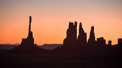
Our first stop was in front of a giant rock monolith, which was to be my subject. I couldn’t see it per se, but I knew it was there because its dark mass blocked out half the stars in the night sky. I set up my tripod on the side of the road.
“You know how to shoot in Manual Mode, right?” Carl asked, nodding at my camera.
Huh? I was a deer caught in the headlights. I’ve had my fancy Nikon now for nine years and never once shot anything except in Auto Mode. I was embarrassed. I had taken all those photography classes (50 years ago!) and I couldn’t remember a thing.
Carl to the rescue. He knew my camera better than I, and deftly adjusted the settings for shooting in manual. Over the next few hours, I would learn plenty from this dude on how to take photos in low-light conditions. With each stop, the sky would become a little brighter, the stars giving way to peach and amber light on the eastern horizon. We ran into Carl’s brother, Carlos, on a low ridge where we could catch the sun coming up. He had a couple of clients along with the same intention. They would be the only people we encountered all morning.
THE FIRST RAYS of the sun warmed my face as I snapped photos of the Totem Pole in the distance. Nearby, I could overhear Carlos explaining to his clients how the Navajo believed everything in the world had a spirit—rocks, trees, rivers, animals, the sun, moon, humans—and that it was vital they stay in balance and harmony. I missed the rest of the conversation because they were too far away. But what was clear is that his clients were not buying it.
Carl had been relatively quiet during the first part of the tour before sunrise. When he did talk, it had been sparse with many pauses in the conversation—which is common in Navajo culture: they speak softly and don’t blabber. But after we waved farewell to Carlos and his clients, he soon began to tell me a story.
“There are two worlds,” he said as he veered up a sandy wash (thank God we had four-wheel-drive). “There is your world... And there is the Navajo world...” He steered around a boulder before continuing. “Those two worlds do not overlap much.”
I had no clue why he was bringing this up. Was it something his brother’s clients had commented on? I was uncertain, so I kept quiet.
“When a Navajo leaves the Rez, it changes him,” he went on. “If he is gone a long time, it changes him a lot. He is not the same person when he comes back.”
When I asked Carl if he had ever lived off the Rez, he nodded. “Las Vegas.”
He went on to tell me that he had moved to Vegas and worked as an ironworker. However, when the Great Recession struck, he lost his job and found himself back home, working for his father's photography tour company. Ironically, despite not being particularly drawn to photography as a child, he discovered a newfound appreciation for it as an adult. After his father's passing, Carl and his brother Carlos reformed the family business and established Phillips Photography. He confided that he had a dream shortly afterwards in which his father imparted a noteworthy piece of advice, urging him to "Make it the way you breathe"—a Diné idiom that lacks an English translation, other than approach the challenge with the same natural ease and necessity as breathing.
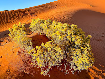
WE STOPPED near a sandstone arch and Carl shut off the engine. We got out. While I snapped photos of the arch, all aglow in the early morning sun, Carl wandered off into the desert. I joined up with him a few minutes later, standing atop a large sand dune. The view from here yielded a geological masterpiece of sculpted dunes and towering mesas; formidable terrain shaped over eons.
“This is where I was standing when I saw it,” he said. He faced a nearby mesa and made a subtle jut with his chin, pursing his lips as he did so. This is the Navajo way of pointing something out. They never ever point with their finger—to do so is rude at best and menacing at worst (sorcerers and witches point when they cast bad luck onto somebody).
“Saw what?” I asked, scrutinizing the rust-toned mesa that he had “pointed” to.
There was a lingering pause. And then he told me.
It had occurred several years ago while Carl was guiding a client on a sunset tour. The sun had gone down, and they were returning to the car in the fading light. That’s when he saw it. And what he witnessed was, by all accounts, incredible—a profound moment that affirmed his purpose and connection to this place. While the specifics are not mine to share, Carl's account speaks to the deep-rooted beliefs entrenched in Diné traditions. For them, the physical and spiritual realms coexist, where dreams, visions and unexplained phenomena are central to daily life. This perspective can challenge those grounded in Western, empirical understanding. But that’s a discussion for another day.
The Anasazi
I WAS FOURTEEN years old when my grandparents took me to see the Mesa Verde cliff dwellings. As I stared up at the 800-year-old adobe village, tucked into the recess of a massive cliff, I couldn't help but wonder about the mysterious people who had built it. Who were they? What had prompted them to construct something so ambitious in such an inaccessible location? And where did they go after abandoning it all? I deemed all these unanswered questions fascinating.
Anthropologists now know that the Anasazi didn’t just suddenly vanish—they were hiding in plain sight. The Pueblo tribes of today—Hopi, Zuni, and various Rio Grande Puebloans—are considered their direct descendants, and the term Anasazi ("Ancient Enemy" in Navajo) is no longer used officially, out of respect for the Pueblo people. Ancestral Puebloan is now the preferred term for the enigmatic cliff dwellers. Though, Anasazi sounds sexier.
The Four Corners region had been inhabited by various tribes for millennia, but around 750 A.D., a more advanced "elite group" began constructing adobe villages in Chaco Canyon. These Elites were either from or heavily influenced by the Toltec culture in central Mexico. Over the next three centuries, the Anasazi spread throughout the San Juan Basin, with the larger communities in Chaco Canyon serving as the central hub for commerce and political power. Extensive trade networks were established with Mesoamerica, and the Elites gained control over corn production, which only strengthened their dominance even further. This period of thriving development is referred to as the Chaco Phenomenon, the greatest indigenous empire in North America, with a population of 30,000 or more. And then, it collapsed.
 |
| Authentic Anasazi pottery is nearly priceless. If you have to ask how much, you can't afford it. |
THE DECLINE of the Anasazi civilization can be traced back to a prolonged mega-drought that began around 1130 A.D. The lack of rainfall severely impacted crop production, leading to depleted granaries. This scarcity of food resources led farmers to question the supposed magical powers of the Elite's priests, sowing seeds of doubt and unrest. Civil strife and intratribal wars raged for years, further destabilizing their society. When the Chaco Canyon power hub dissolved, its population dispersed to outlying areas, constructing small, fortified villages into the sides of cliffs as a means of survival in the face of water scarcity. The Chaco Phenomena had come to an end. By the time the Navajo-Apache people arrived in the 14th century, the Anasazi had seemed to vanish, leaving behind deserted cliff dwellings and the ruins in Chaco Canyon.
Diné oral history recounts the fate of the Ancestral Pueblo in the metaphoric narrative of The Big Gambler. In the story, Sun Spirit has an insatiable desire for a precious turquoise stone that belongs to the Anasazi in Chaco Canyon, and he sends his first-born son, Big Gambler, to fetch it—and anything else he wishes to take—by any means. The datura plant, gaming, and betting the odds all play a part in Big Gambler's scheme of drugging his adversaries and filching everything they have—including the bountiful rain—and leaving them destitute and enslaved. How much of this cautionary tale of greed and exploitation is true, is anyone’s guess. But recent archeological evidence supports a violent end was likely.
Canyon de 'Chelly
THE LAST STOP of my journey was Chinle (pop. 3,800), gateway to the extraordinary Canyon de ’Chelly. This winding gorge, carved deep into the Colorado Plateau, has served as home for various indigenous peoples for countless centuries. Today, it is designated as a National Monument, co-managed by the National Park Service and the Navajo Nation. There was no escaping it—visiting de ’Chelly felt like the perfect finale to an epic adventure.
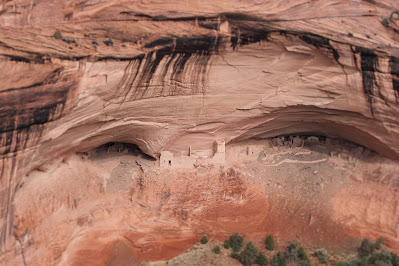
I spent my first day exploring both the north and south rims of the canyon, hiking numerous trails to breathtaking views in the early morning and late-afternoon light. The solitude was profound. And Toby and Wolfgang, ever the adventurous companions, certainly relished the chance to explore the trails. They were in their element as well. What was especially thrilling were the moments when I spotted the ancient ruins of a cliff dwelling in the opposite canyon wall, partially obscured by deep shadows. Canyon de ‘Chelly has borne witness to the ebb and flow of successive civilizations. The Anasazi inhabited it for 500 years, building elaborate dwellings in the clefts of giant canyon walls to create the highest concentration of cliff dwellings in North America (possibly the world?), and yet, by the 14th century, they mysteriously abandoned it all. In their wake, the Hopi periodically used the canyon for seasonal habitation for at least another two centuries. Finally, around the early 1700s, the Navajo moved in and claimed it as their own, a legacy that continues to this day.
When I returned to the trailhead at sunset, there was only one other vehicle in the parking lot: a dusty pickup truck. Two Diné teenagers, a boy and a girl, sat in the cab, sharing a bag of Doritos. The girl was shy, and the boy was polite, his long, black hair pulled back in the traditional braided ponytail. Their body language revealed their mutual attraction. Wolfy ambled up to the girl's door, tail wagging excitedly like you’re his long-lost friend, and begged for a chip (his standard M.O.). The girl laughed in delight. They were seniors at Chinle High School. It was a Friday, and a big football game awaited in town: Chinle versus Shiprock. It was another autumn evening in Navajo country.
 |
| Chinle’s tranquil campground was only a quarter full at most. |
 |
| Black Rock Canyon fork. |
 |
| Looking down at Antelope House from the canyon rim. Tucked into a recess at the base of the wall, the site was carefully excavated by archeologists in the 1970s. They uncovered stratified remnants from thousands of years of occupation, spanning Archaic Basket Maker, Anasazi, Hopi, and Navajo cultures. |
 |
| Canyon de ‘Chelly from the south rim. |
 |
| Tourists. |
In Canyon with Reggie
THE LOGISTICS for exploring the interior of Canyon de ‘Chelly are more involved than my reconnoiter along its rim. For one, the entire floor of the canyon is private property; visitors cannot wander in on a whim. There are also multitudes of archaeological sites that must be protected. And then there’s the quicksand. All of this obliges one to secure a four-wheel-drive and Diné guide to get you past go. I booked with Canyon de ‘Chelly Tours in Chinle, which was founded by the late Leon Skyhorse Thomas, a veteran guide; documentary filmmaker; actor (had a small role in Oliver Stone’s “Natural Born Killers”). When he tragically passed away from COVID-19 complications two years ago (2020), his daughter, Tanya Yazzie, took over the business. She set me up with one of her guides, Reginald Etsiity, a.k.a. Reggie the Flute Player. He arrived at my campsite promptly at eight o'clock in the morning and we were off, bouncing and jostling into the canyon in his ready-for-anything Hummer.
Reggie knew the canyon like the back of his hand, having grown up in it. (Around forty families live in Canyon de ‘Chelly, off the grid with no electricity or running water.) When he was old enough to start an institutionalized education, he was bussed into Chinle. He didn’t speak a word of English until he learned it in elementary school—where he wasn't allowed to speak Diné, not even at recess. As teenagers, Reggie and his brother explored the canyons even further, ascending precarious routes that had been used for countless centuries to gain access to the canyon rim. He pointed out one of them to me: a meandering line that exploited a weakness up a 500-foot sandstone wall, and I could just make out the rickety wood ladder that was dangling up there, about halfway up. Without a doubt, one slip in the wrong place would be fatal.
THE ROAD was nothing more than deep sand in places. We passed a rusted-out vehicle buried in it like a shipwreck. And then another one. I was glad Reggie was driving. There are in fact three major canyons here—Chelly, Muertos, and Monument—but Chelly is the longest at twenty miles. In addition, dozens of tributary canyons flow into these to create a labyrinth of disorientation, where sense of direction can be tricky for the uninitiated. Quicksand sloughs are common, especially in winter and spring, adding yet another hazard. But Reggie had mastered the technique—steady on the gas, but not too fast; a metrical dance of the steering wheel in the sandy sections… And NEVER, under any circumstances, hit the brakes.
We came upon the first cliff dwelling, aptly named First Ruins, two miles into the canyon. A little further was Junction Ruins, located at the confluence of Muertos and ‘Chelly Canyons. Though ruins abound throughout the canyon, blending incognito onto ledges and in clefts, only the most significant ones—thirteen to be exact—have been reinforced and protected from further degradation. Scholars believe that around 800 people lived here during the Anasazi heyday in the 12th century. A thousand years ago, rainfall was significantly more than it is today. The creeks flowed year-round. Corn and squash flourished on the canyon floor, as did stands of pinyon pine. There were probably meadows. Deer were plentiful. This was the world of the Ancestral Puebloan—and within one generation, it was gone.
To get a closer look, Reggie parked the Hummer and we proceeded on foot through a cottonwood grove, scrambling up sandstone slabs to a line of ancient Moki steps that had been carved into steep rock.
“They go to the canyon rim,” Reggie said, nodding subtly at the steps. Not that we were going to the canyon rim. After climbing up several dozen steps, we traversed over to a prominent outcropping that afforded a picturesque view up and down the canyon. Directly across from us, I could see what appeared to be ruins on a ledge, though they looked too small to be dwellings.
“They’re granaries,” Reggie told me, explaining that the Anasazi intentionally placed them in high, difficult-to-access locations. They were constructed from sandstone rocks, sealed together with clay mortar to make the structure exceptionally watertight. Workers stacked corn neatly against the walls inside and built a fire in an open space in the middle of the room. While the fire burned, they would seal off the doorway with rocks and mortar to make it airtight. The fire would extinguish itself once it had consumed all the oxygen. And without oxygen, the corn inside wouldn't decay and could last for years (even centuries!). It was an ingenious system to ensure long-term food preservation.
 |
| First Ruin |
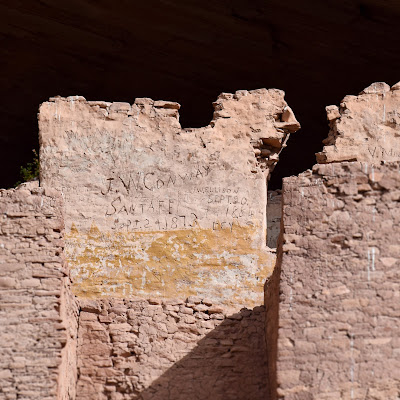
DRIVING DEEPER into Canyon de 'Chelly, the next stop is White House Ruins, one of the most iconic and recognizable Anasazi ruins in the Desert Southwest. It got its name from the faded but distinctive white plaster used on the dwelling walls. Most of the ruins are tucked into a giant shelf that is eighty feet off the ground, accessible today only with an exceptionally tall ladder. The remains of a multi-story structure at the base of the cliff once connected to the dwellings above, and contained several circular kivas, reminiscent of those at Chaco Canyon (100 miles east of here). Based on dendrochronology research, scholars believe that White House was inhabited from 1060 to 1275 and housed approximately one hundred people. I took a great deal of photos here, wandering around and staring up in wonder. I tried to envision what it was like eight centuries ago with dozens of cliff dwellers going about their daily tasks while small children frolicked. If only these canyon walls could talk.
The Ancestral Puebloans had vanished long before the Navajo arrived on the scene. Reggie conveyed that his people never resided in the abandoned cliff dwellings, believing them to be haunted by chindis. Even to walk among the ruins could disturb unseen forces and bring bad luck or death to the intruder: ominous reminders of a people that had disappeared long ago, leaving behind an aura of mystery.
WE NEXT doubled back and ventured into Canyon del Muerto, which was more winding and intimate than Canyon de ‘Chelly. Along the way, Reggie shared yarns of 19th century resistance against encroaching White settlers (they should’ve built a wall). The Navajo have endured many onslaughts, most notably a massacre by Spanish troops in 1805, and an invasion of the U.S. Army in 1863 under Kit Carson. In an attempt to fix the problem permanently, Carson ordered all their villages and crops to be burned, including the destruction of 8,000 beloved peach trees. Even today, the Diné have not forgotten Kit Carson.
The weight of this painful past hung in the air as we approached the Ledge Ruins, located in a natural amphitheater two miles into the canyon. We climbed out of the Hummer to look around. Reggie pulled out his flute and played a somber melody, the notes echoing off the canyon walls in an eerie yet peaceful way. I snapped photos of the ruins perched on the ledge above, humbled by the fact that the canyons here had been home to many cultures—first the Anasazi, then the Hopi, and finally the Navajo… Ten centuries. I was no more than a small observer in the grand tapestry of time. How could I not sense the awe?
 |
| Canyon del Muerto |
 |
| Ledge Ruins. |
 |
| Reggie plays his flute. |
Epilogue...
I PACKED UP in the morning and prepared for the long journey home, my fifteen whirlwind days in the Desert Southwest coming to an end. The last six nights in the Navajo Nation were especially rewarding. There was a sense of wonder for the incredible sights and fascinating people I had encountered—the full impact of which was still sinking in. Though sad to leave, I felt fortunate to have enduring memories.
As I drove out of Chinle, I saw a loose steer loping through the sagebrush along the road. A Diné boy, probably high school age, was pursuing it on horseback at a brisk canter, looking quite at ease in the saddle. He pulled out his lariat, and I slowed down to match their speed so I could watch. If the steer cut left, it would cross the highway in front of me. The kid drew closer to the steer, twirling the lariat over his head, and then he threw it—and missed. But he wasn’t deterred. Still cantering close to the steer, he coiled the lariat back with ONE HAND and closed in for a second attempt. I held my breath as he cast again, this time lassoing the steer's head. Got him! I cheered and honked my horn. Even the dogs caught the rodeo spectacle from the side windows.
For the most part, the Diné still live close to the ground: a time capsule of a simpler, less-materialistic life. Watching the boy lasso the steer was icing on the cake. It made my day. I drove on, south across Navajoland, and hopped on I-40 in Winslow, Arizona with “Take It Easy” playing on the stereo.


